Colonia Tlatelolco in Ciudad de México, Mexico — The Valley of Mexico (The Central Highlands)
From peaceful convent to bellicose military barracks
De apacible convento, a bélico cuartel militar
Inscription.
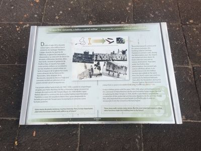
Desde el siglo XVI y durante varios siglos, este edificio fue el convento de Santiago Tlatelolco. Luego, durante las guerras de Reforma, la iglesia fue saqueada y clausurada y su colección de libros fue enviada a diferentes destinos. Años más tarde, durante el gobierno de Porfirio Díaz, el claustro fue usado como prisión militar y en su extremo sur fue añadido el cuartel militar; en tanto el espacio de la iglesia fue usada como almacén de los Ferrocarriles Nacionales. Años después de la Revolución, durante la Decena Trágica el convento recibió un cañonazo en su pared oriental casi en la esquina sur.
Fue prisión militar hasta el año de 1945-1948, cuando los arqueólogos dirigidos por Pablo Martinez del Rio y Antonieta Espejo iniciaron los trabajos de exploración del Templo Mayor. En 1958 Adolfo López Mateos decidió la construcción de la unidad habitacional Nonoalco Tlatelolco a cargo del arquitecto Mario Pani, quien desprendió la fachada principal del Tecpan para incorporarla al convento como fachada posterior.
Estos muros de piedra encierran muchas historias. Pero, lo más importante: ¿Qué otras funciones tendrá este edificio en el futuro?
Pie de dibujos:
A través del tiempo este edificio fue cambiando su función, pasando de lo religioso a lo militar.
Convento
Cañonazo
Iglesia de Santiago
Prisión Militar
Since the sixteenth century and for various centuries, this building acted as Santiago Tlatelolco’s convent. Later, during the Reformation wars, the church was looted and shut down. Its book collection was sent to various destinations. Years later, under the Porfirio Diaz administration, the convent was used as a military prison. In its southernmost end, the military barracks was added; at the same time, the church space was used as a warehouse for National Railroads. Years after the Revolution, during the Decena Tragica, the convent received a blow from a canon in its eastern wall, almost in the southern center.
It was a military prison until the years 1945-1948, when archeologists under the command of Pablo Martinez del Rio and Antonieta Espejo began the task of exploring the Main Temple. In 1958, Adolfo Lopez Mateos assigned the construction of the residential unit Nonoalco Tlatelolco to the architect Mario Pani, who separated the principal façade from the Tecpan in order to incorporate it into the convent as the back façade.
These stone walls contain many stories. But the most important aspect is: What other functions might
this building have in the future?
English translation of the captions:
During the course of time this building has changed its function, passing from religious to military uses.
Convent
Damage caused by a cannon strike
Church of Santiago
Military Prison
Erected by Conaculta.
Topics. This historical marker is listed in these topic lists: Anthropology & Archaeology • Man-Made Features • Wars, Non-US. A significant historical year for this entry is 1958.
Location. 19° 27.058′ N, 99° 8.217′ W. Marker is in Ciudad de México. It is in Colonia Tlatelolco. The marker is just south of the main western entrance to the Church of Santiago Apostol on Eje Central near the intersection with Avenida Ricardo Flores Magón. Touch for map. Marker is in this post office area: Ciudad de México 06900, Mexico. Touch for directions.
Other nearby markers. At least 8 other markers are within walking distance of this marker. Santiago Church (a few steps from this marker); Full color Tlatelolco: The temple of the paintings (within shouting distance of this marker); Coyolxauhqui: The dismembered goddess (within shouting distance of this marker); Church of Santiago (within shouting distance of this marker); Friar Bernardino Sahagún (within shouting distance of this marker); Favor request…and talent for the gods (within shouting distance of this marker); Battle of Tlatelolco (within shouting distance of this marker); Tlatelolco’s great temple (“Templo Mayor”): A mirrored image of Tenochtitlan (within shouting distance of this marker). Touch for a list and map of all markers in Ciudad de México.
Credits. This page was last revised on April 17, 2020. It was originally submitted on January 6, 2016, by J. Makali Bruton of Accra, Ghana. This page has been viewed 490 times since then and 10 times this year. Photos: 1, 2. submitted on January 6, 2016, by J. Makali Bruton of Accra, Ghana.

