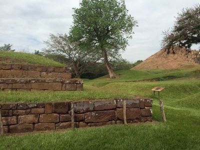
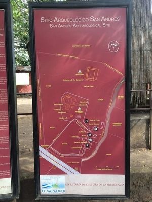
Near San Andrés in San Juan Opico, La Libertad, El Salvador — Central America (West Coast)
San Andrés Archaeological Site
Sitio Arqueológico San Andrés
Ubicación
En el valle de Zapotitán, municipio de Ciudad de Arce, departamento de La Libertad.
Coordenadas (al centro de la Acrópolis):
N 13º 48’ 3.7” latitud, W 89º 23’ 21.7” longitud
UTM 24168mE/1527010mN 16P (WGS84)
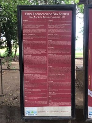
El lugar donde usted se encuentra es uno de los principales sitios arqueológicos del país y tiene evidencia de actividad humana que se remonta a casi 3,000 años (al menos que se indica lo contrario, las fechas que se dan a continuación son aproximadas.)
900 a.C. hasta 420 d.C.:
Una comunidad agrícola de tamaño considerable se desarrolló aquí, en las riberas del Río Sucio, en el valle de Zapotitán. Sus habitantes probablemente eran mayas.
420 d.C.:
La gigantesca erupción de Ilopango arrojó ceniza (“tierra blanca”) sobre gran parte del centro y occidente del territorio salvadoreño. El valle de Zapotitán fue cubierto por unos dos metros o más de tierra blanca. San Andrés y los demás sitios conocidos en el valle fueron abandonados.
500-600 d.C.:
Se recoloniza el valle de Zapotitán. La ceniza volcánica depositada por la erupción de Ilopango fue estéril en un principio. Sin embargo, después de varias décadas, fue posible cultivar la “tierra blanca,” y agricultores mayas (procedentes del occidente) fundan nuevos asentamientos en el valle. San Andrés es repoblado.
600 a 900 d.C.:
San Andrés se convierte en la mayor comunidad de su región, con una extensión superior a 200 hectáreas (385 manzanas). Su mayor parte consistía en una zona residencial, la cual rodeaba el centro monumental donde usted se encuentra. El centro monumental se divide entre la Gran Plaza, y la Acrópolis. La Acrópolis cuenta con pirámides (que probablemente contengan tumbas reales) y estructuras largas que tal vez representa un palacio. El reino establecido en San Andrés habría llegado a dominar los demás pueblos del valle de Zapotitán y hasta alguna distancia más allá del valle.
900 d.C.:
Al igual que muchas comunidades mayas, San Andrés se abandona en circunstancias todavía no esclarecidas entre 850 y 900 d.C. Hay señales de quema en las circunstancias sobre la Acrópolis, en donde fueron regados fragmentos de objetos de un grupo cultural “nuevo” (la fase Guazapa, representada en el sitio arqueológico Cihuatán.)
Alrededor de 1600 a 1658 d.C.:
Para principios de los 1600s, el área de San Andrés formaba parte de una hacienda
colonial en donde se criaba ganado. La nueva bonanza del añil fue aprovechada en esta hacienda y se construyó un obraje de añil grande junto al río Sucio, a poca distancia de las pirámides prehispánicas que se hallaban en ruina.
1658 d.C.:
Fecha de la erupción de El Playón resultó en el soterramiento del obraje de añil de San Andrés, y de la infraestructura de otras haciendas en el valle. Los cultivos de varios pueblos indígenas fueron dañados, y uno de ellos (Nejapa) tuvo que trasladarse.
1891 d.C.:
El sitio arqueológico, que se encontraba dentro de la hacienda San Andrés, fue notado por primera vez en esta fecha.
1940 a 1941:
Fechas de a primera investigación arqueológica de San Andrés.
1977:
En este año, San Andrés fue declarada Monumento Arqueológico Nacional por la Asamblea Legislativa.
1980:
Con la reforma agraria de 1980, la hacienda San Andrés fue expropiada y posteriormente entregada a una cooperativa. Parte de área del sitio arqueológico fue reservada para el actual Parque Arqueológico San Andrés.
Location:
In the Zapotitán Valley, municipality of Ciudad de Arce, Departamento of La Libertad.
Coordinates (at the center of the Acrópolis):
N 13º 48’ 3.7” latitude, W 89º 23’ 21.7” longitude
UTM 24168mE/1527010mN
16P (WGS84)
The place where you stand is one of the principal archaeological sites of El Salvador, with evidence of human activity reaching back nearly 3,000 years (unless otherwise indicated, the following dates are approximate.)
900 BC to 420:
An agricultural community of considerable size developed here, along the banks of the Sucio River within the Zapotitán valley. Its inhabitants were probably Mayas.
AD 420:
The gigantic eruption of Ilopango deposited volcanic ash (known as “tierra blanca”) over a large part of central and western El Salvador. The Zapotitán Valley was covered by two meters (6.5. feet) or more of “tierra blanca”. San Andrés and other known sites in the valley were abandoned.
AD 500-600:
The Zapotitán Valley is recolonized. The volcanic ash erupted by Ilopango was sterile at first, but after several decades weathered sufficiently to be cultivable by Maya immigrants from the west, who founded new settlements in the valley. San Andrés is repeopled.
AD 600 a 900:
San Andrés becomes the largest community of its region and covered an area larger than 200 hectares (500 acres), its consisted largely of a residential zone which surrounded the monumental center where you stand. The monumental center is divided between the Great Plaza and the Acropolis. The Acropolis

Photographed By J. Makali Bruton, January 9, 2016
4. Trenches were excavated to investigate the Acropolis
This first marker along the walkway around the site just north of Structure 7 and southeast of Structure 1 reads:
Durante la década de 1970, se realizaron excavaciones para conocer los limites de "La Acrópolis". Las trincheras arqueológicas se pueden observar a manera de depresiones en el terreno. Pie del dibujo: El color naranja rodea la trinchera arqueológica.
English:
During the decade of the 1970, excavations to identify the limits of the acropolis took place. The archaeological trenches can by identified by the depressions on the ground. Caption: The orange color surrounds the archaeological trench.
During the decade of the 1970, excavations to identify the limits of the acropolis took place. The archaeological trenches can by identified by the depressions on the ground. Caption: The orange color surrounds the archaeological trench.
AD 900:
As was the case for many Maya communities, San Andrés is abandoned between AD 850-900 for reasons which have yet to be firmly identified. There are signs of burning in the structures on the Acropolis, where excavations revealed a final occupational layer with scattered fragments of artifacts belonging to a “new” cultural group (the Guazapa Phase, represented at the Cihuatán archaeological site).
Approximately AD 1600 to 1658:
By AD 1600, the area of San Andrés formed part of a Colonial hacienda. Cattle ranching was important here as well the new indigo boom. A large indigo processing facility, or “obraje de añil” was built next to the Sucio River within sight of the ancient pyramids.
AD 1658:
Date of the El Playón eruption which caused the indigo facility (“obraje de añil”) to be deeply buried. Other haciendas in the Zapaotitán Valley were also affected. Several native communities suffered crop losses, and one of them (Nejapa) had to be relocated.
1891:
The archaeological site, which was within the Hacienda San Andrés was noted for the first time.
1940 a 1941:
The first archaeological investigation at San Andrés took place between these dates.
1977:
On this date, the Legislative Assembly declared San Andrés a National Archaeological Monument.
1980:
With the agrarian reform of 1980, the Hacienda San Andrés was expropriated and eventually turned over to a cooperative. Part of the area of archaeological site was reserved for the present San Andrés Archaeological Park.
Erected by Secretaría de Cultura de la Presidencia de El Salvador.
Topics. This historical marker is listed in these topic lists: Anthropology & Archaeology • Man-Made Features. A significant historical year for this entry is 1600.
Location. 13° 47.993′ N, 89° 23.346′ W. Marker is near San Andrés, La Libertad, in San Juan Opico. Marker can be reached from Kilómetro 32 Carretera Panamericana. The marker is on the grounds of the San Andrés Arqueological Site, near the beginning of the walkway around the site. Touch for map. Marker is in this post office area: San Andrés, La Libertad 01514, El Salvador. Touch for directions.
Other nearby markers. At least 8 other markers are within 18 kilometers of this marker, measured as the crow flies. Structure 7 at San Andrés Archaeological Site (within shouting distance of this marker); San Andrés was an extensive prehispanic settlement (within shouting distance of this marker); Abandonment of the San Andrés Archaeological Site (about 90 meters away, measured in a direct line); Indigo Production at San Andrés (about 240 meters away); Joya de Cerén (approx. 4.7 kilometers away); The San Salvador Volcano Complex (approx. 6.5 kilometers away in San Salvador); El Boqueron National Park (approx. 13.9 kilometers away); Santa Tecla Culture and Arts Center (approx. 17.6 kilometers away). Touch for a list and map of all markers in San Andrés.
Credits. This page was last revised on July 28, 2019. It was originally submitted on February 20, 2016, by J. Makali Bruton of Accra, Ghana. This page has been viewed 479 times since then and 22 times this year. Photos: 1, 2, 3, 4. submitted on February 20, 2016, by J. Makali Bruton of Accra, Ghana.


