Sioux City in Woodbury County, Iowa — The American Midwest (Upper Plains)
Sergeant Floyd Monument
Inscription.
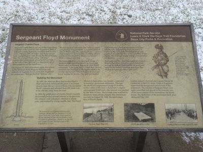
Sergeant Charles Floyd
Sergeant Charles Floyd was one of the outstanding members of the Lewis & Clark Expedition. Born in Jefferson County, Kentucky sometime between the years 1780 and 1785, his father and uncles served with George Rogers Clark during the Revolutionary War. The younger Floyd, along with other handpicked frontiersmen, joined Lewis & Clark at the Falls of the Ohio and was appointed one of three sergeants for the expedition.
On August 19, 1804, after ninety-eight days of toil up the Missouri River, Sergeant Floyd became violently ill. Captains Lewis and Clark diagnosed his ailment as a "Beliose Chorlick" (bilious colic).
Modern medical authorities now believe it was a complication of appendicitis, a condition without cure in Floyd's day. The captains wrote: "...Serjeant Floyd as bad as he can be no pulse & nothing will Stay a moment in his Stomach or bowels." Lewis and Clark could not save him.
The boats pulled up to the east bank (at the southern edge of present Sioux City, Iowa) just before noon on Monday, August 20, 1804. Floyd whispered, "I am going away…" and died. He was carried by his comrades to the highest bluff in the vicinity and buried with full honors of war, Capt. Lewis leading the service. The spot was marked with a red cedar post carved with Floyd's name and the date. Sergeant Floyd was the first U.S. soldier to die west of the Mississippi River and would be the only member of the expedition to lose his life. The bluff and nearby stream were named in his memory.
Two years later, the returning expedition visited Floyd's Bluff. They found the grave disturbed perhaps by wolves. They refilled the grave and replaced the marker. Nineteen days later they reached St. Louis to a hero's welcome.
upper right caption:
". . . Sgt. Floyd died with a great deal of composure... This man at all times gave us gave us proofs of his firmness and Determined resolution to do Service to his Countrey and to honor himself . . . "
From the journal of Captain Clark, August 20, 1804
Building the Monument
By 1857, the Missouri River had eroded Floyd's Bluff and nearly destroyed the grave. Concerned citizens from the new town of Sioux City recovered Floyd's remains and reburied them 200 yards east of the old site, away from the river.
In 1894, the publication of Charles Floyd's recently discovered journal revived interest in his gravesite. His remains were exhumed, reburied in sturdy urns, and marked by a large marble slab. The Floyd Memorial Association was formed, committed to erecting a permanent monument. Through the efforts of Congressman George D. Perkins, former editor of the Sioux City Journal, Congress appropriated $5,000 and a like amount was granted by the State of Iowa. These funds were matched by donations from private citizens. The cornerstone was laid on August 20, 1900, the anniversary date of Floyd's death.
Captain James C. Sanford and Captain Hiram M. Chittenden of the U.S. Army Corps of Engineers supervised the design and construction of the monument. The remains of Sergeant Floyd were again unearthed and placed in the concrete core of the lower courses of the monument, his fourth burial. The dedication of the monument took palace Memorial Day, 1901.
lower left caption:
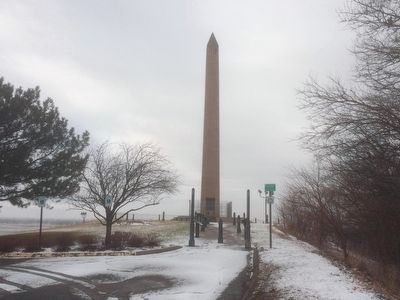
The monument is an Egyptian obelisk of white sandstone 100 feet high. Its foundation is 22 feet square at the base, 11 feet high, 14 feet square at the top, and made of solid concrete reinforced with 32 lengths of railroad irons. Poured in one day, this mass weights 278 tons. The total weight of the monument is 717 tons.
photo captions (from left to right):
View from Floyd's Bluff 1895
Marble slab placed in 1895
Laying of the cornerstone August 20, 1900
Erected by National Park Service, Lewis & Clark Heritage Trail Foundation, and the Sioux City Parks & Recreation.
Topics and series. This historical marker and monument is listed in these topic lists: Cemeteries & Burial Sites • Exploration • Settlements & Settlers. In addition, it is included in the Lewis & Clark Expedition series list. A significant historical date for this entry is August 19, 1804.
Location. 42° 27.756′ N, 96° 22.656′ W. Marker is in Sioux City, Iowa, in Woodbury County. Marker can be reached from South Lewis Boulevard, 0.3 miles Lincoln Way. Located at the base and on the east side the the Floyd Monument. Touch for map. Marker is in this post office area: Sioux City IA 51106, United States of America. Touch for directions.
Other nearby markers. At least 8 other markers are within 3 miles of this marker, measured as the crow flies. The Death of Sergeant Floyd (a few steps from this marker); The Lewis & Clark Expedition (a few steps from this marker); Sergeant Charles Floyd (within shouting distance of this marker); Floyd Monument (within shouting distance of this marker); First Bride's Grave (approx. 0.3 miles away); Herbert Quick Ravine (approx. 0.4 miles away); MA1 (EXW) John Douangdara (approx. 1.1 miles away in Nebraska); Pacific Short Line Bridge (Nebraska Side) (approx. 2.4 miles away in Nebraska). Touch for a list and map of all markers in Sioux City.
Credits. This page was last revised on July 16, 2021. It was originally submitted on February 29, 2016, by Ruth VanSteenwyk of Aberdeen, South Dakota. This page has been viewed 850 times since then and 71 times this year. Last updated on July 14, 2021. Photos: 1, 2. submitted on February 29, 2016, by Ruth VanSteenwyk of Aberdeen, South Dakota. • Mark Hilton was the editor who published this page.

