South Park in Buffalo in Erie County, New York — The American Northeast (Mid-Atlantic)
Ecological Restoration
Enhanced aquatic habitat and eco-system stabilization
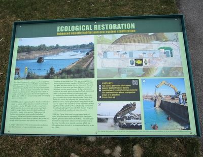
NYSDEC and the engineering firm Arcadis combined to create an aquatic habitat plan that made the ecological restoration a reality. The plan includes a canal berm which supports the northern and eastern canal walls, while creating a shallow water fish habitat and tiered benches for aquatic plant species. Underwater fish habitat structures have been installed, including submersed willow trees. Benthic substance materials were placed on the canal floor to enhance the growth of aquatic micro-organisms and stabilize the eco-system.
A unique component of the environmental remediation was the placement of geotextile fabric over the sediment on the canal floor. This was accomplished by sewing a piece of fabric together, 2000 feet long by 200 feet wide, and then sinking it to the bottom of the canal. One foot of clean stone was then deposited on top of the fabric over the entire bottom. In the northeastern corner of the canal, where the canal wall had deteriorated down to the wood cribbing, an embayment area (or wetland) has been created that replicates the ecological condition that existed throughout the Union Ship Canal area before the industrial era. Twenty-six (26) different native, aquatic plant species were placed in the canal to support fish and other aquatic organisms, including Pickerel Weed, Yellow Pond Lily, Swamp Loosestrife, Arrowhead, and Sago Pondweed. Fish that are frequent to the canal include smallmouth bass and perch.
While the Union Ship canal is not a natural body of water, it has become an important location for aquatic habitat, given its direct link to Lake Erie. The ecological restoration components enhance the transformation of the canal toward a more natural waterway, which has taken place since the end of its commercial activity in the late 1980s.
Photo key:
1) Tug pulling geotextile fabric cover.
2) Aquatic Habitat Plan and Details.
3) Installation of Benthic Substrate material (the sediment layer where an organism grows or is attached.
4) Canal clean-up.
Erected by New York State Department of State.
Topics. This historical marker is listed in this topic list: Environment. A significant historical year for this entry is 2000.
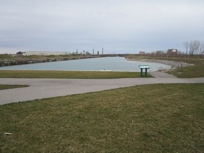
Location. 42° 50.18′ N, 78° 50.801′ W. Marker is in Buffalo, New York, in Erie County. It is in South Park. Marker is on Ship Canal Parkway, 0.2 miles south of Tifft Street, on the right when traveling south. The Union Ship canal extends inland from Lake Erie, ending at the marker. The canal segments Furhmann Boulevard, which parallels the lakeshore. Ship Canal Parkway & Laborers Way connect the segmented ends of Furhmann Boulevard in a U shape by looping around the Canal. There is a small parking area a few dozen paces from the marker. Touch for map. Marker is in this post office area: Buffalo NY 14218, United States of America. Touch for directions.
Other nearby markers. At least 8 other markers are within walking distance of this marker. Industrial Icons (within shouting distance of this marker); Hanna Furnace (approx. 0.2 miles away); Ship Canal Commons (approx. 0.2 miles away); Environmental Remediation (approx. 0.3 miles away); Wind Power on the Waterfront (approx. 0.4 miles away); Bethlehem Steel in Lackawanna (approx. 0.4 miles away); a different marker also named Bethlehem Steel in Lackawanna (approx. 0.4 miles away); Railroads and the Steel Industry (approx. 0.4 miles away). Touch for a list and map of all markers in Buffalo.
Credits. This page was last revised on February 16, 2023. It was originally submitted on April 14, 2016, by Anton Schwarzmueller of Wilson, New York. This page has been viewed 347 times since then and 13 times this year. Photos: 1, 2. submitted on April 14, 2016, by Anton Schwarzmueller of Wilson, New York.

