Near Bordeaux in McCormick County, South Carolina — The American South (South Atlantic)
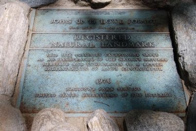
John De La Howe Forest
has been designated a
Resigtered
Natural Landmark
This site possesses exceptional value
as an illustration of the nation's natural
heritage and contributes to a better
understanding of man's environment.
Erected 1976 by the National Park Service, United States Department of the Interior.
Topics. This historical marker is listed in these topic lists: Environment • Landmarks • Natural Resources.
Location. 33° 56.137′ N, 82° 23.729′ W. Marker is near Bordeaux, South Carolina, in McCormick County. Marker is on Tomb Road. Touch for map. Marker is in this post office area: Mc Cormick SC 29835, United States of America. Touch for directions.
Other nearby markers. At least 10 other markers are within 4 miles of this marker, measured as the crow flies. John De La Howe School Lethe Farm Trail (within shouting distance of this marker); New Bordeaux Worship Site (approx. 0.7 miles away); New Bordeaux (1764) (approx. 1.4 miles away); De La Howe Hall (approx. 2 miles away); John De La Howe School (approx. 2.1 miles away); John De La Howe School Enterprise Market Program at "The Barn" (approx. 2.1 miles away); John De La Howe / John De La Howe School (approx. 2.2 miles away); Andre Guillebeau (approx. 2.8 miles away); Guillebeau Home and Family Cemetery (approx. 2.9 miles away); Badwell / Badwell Cemetery (approx. 3.7 miles away). Touch for a list and map of all markers in Bordeaux.
More about this marker. The marker is at the southern end of Tomb Road. Also in the same area is the burial plot of John de la Howe and several close family members.
Also see . . .
1. John De La Howe School. South Carolina Encyclopedia website entry:
Originally founded in 1797 as a farm school for local poor and orphaned children, John de la Howe School has evolved into a first-rate, child caring agency committed to meeting the behavioral, educational, and social needs of the children in its care. (Submitted on December 18, 2009, by Brian Scott of Anderson, South Carolina.)
2. Facebook: John de la Howe School. Official Facebook page of the John de la Howe School. (Submitted on December 18, 2009, by Brian Scott of Anderson, South Carolina.)
3. List of National Natural Landmarks in South Carolina. There are six National Natural Landmarks in the U.S. state of South Carolina. (Submitted on December 18, 2009, by Brian Scott of Anderson, South Carolina.)

Photographed By Brian Scott
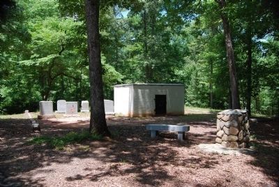
2. John De La Howe Forest Marker and Cemetery
The white structure is De Le Howe's Crypt. His wishes were that his grave not be marked by a headstone or monument, but by a wall. Others buried in the small cemetery are: Grave 1: Rev. James Bennett Branch, Aug 2, 1882-Jul 8, 1931, Superintendent of the de la Howe School, 1919-1931; his wife, Nora Pryse Branch, Apr 3, 1881-May 4, 1983. Grave 2: James Bennett Branch, Born Nov 13, 1921, Died May 10, 1945; He gave his life in the service of his country at the battle of Okinawa in WWII. Grave 3: Mary Naomi Beard, Mar 12,1909-Jun 9, 1936, wife of P.B. Moragne. Grave 4: Ernest Gray, Born Jul 28, 1916, Died May 18, 1929. Grave 5: In memory of Clifford Williams, Jan 1, 1919-Jan 23, 1929. Grave 6 and 7: Unmarked.
Additional commentary.
1. About John de la Howe
The welfare of orphans not taken into homes was mainly left to individual benefactors. John de la Howe settled on the Savannah River after the revocation of the Edict of Nantes. In 1797 he left instructions in his will for his estate to provide for the education and support of twelve poor boys and twelve poor girls, preference to be given to orphans, so that they might be educated in a manner similar to that of an independent French peasant. (Source: In My Father's House Are Many Mansions: Family and Community in Edgefield, South Carolina by Orville Vernon Burton (1987), pg 144.)
— Submitted December 18, 2009, by Brian Scott of Anderson, South Carolina.
2. The De La Howe Gift
Dr. John De La Howe, of Abbeville District, on the 7th day of September, 1796, made his last will and testament and thereby gave all of his estate, consisting of both personal and real, to the Agricultural Society of South Carolina, in trust, for the purpose of establishing on the plantation where he resided an agricultural farm and school, out of the yearly income, to feed, clothe and educate twelve poor boys and twelve poor girls, giving orphan children the preference. The testator requested Peter Gibert, Esq., to act as executor of the will until the Agricultural Society should name some of its members to perform that duty. By a codicil, without date, he appointed William Hutton a joint executor with Mr. Gibert. Dr. De La Howe died on the 2d day of January, 1797, and his will was admitted to probate on the 27th of March, 1797, by the County Court of Abbeville. An appraisement was made on the 5th of April, 1797. The appraised value of the personal property at that time amounted to $5,438.68.
In 1805 the Agricultural Society surrendered their trust to the Legislature, who accepted it, and by Act passed on the 14th of December, same year, appointed Col. Joseph Calhoun, Peter Gibert, Andrew Norris, Rev. Moses Waddel, Ezekiel Calhoun, trustees, to carry into effect the terms of the will, conferring on them the power to fill their own vacancies, and directed them to account Annually to the Ordinary of Abbeville District.
On the 30th of December, 1806, the trustees sold the residue of the personal property. This sale amounted to $6,556.14. On the 27th of June they returned a statement of the personal estate, at that time amounting to $10,639.69.
The real estate consisted of quite a number of tracts of land situated in the Districts of Abbeville, Edgefield, and on the Edisto River. A certain part of the land was sold about this time, which produced a sum—added to the amount realized from sale of personal property—aggregating some $32,237.
The institution has had a changing experience since the above date. Today the institution is in possession of 2,700 acres of land, valued at $54,000, besides having $14,000 invested in good bonds. There is erected on the premises one brick building containing twelve rooms for the use of Superintendent and girls, and one four-room brick building for the boys, a commodious chapel in which preaching is held regularly—preacher paid by the trustees. The annual income of the farm is $3,500; expenses for maintaining school, Superintendent, etc., are $2,000.
In view of the above facts, it is strange to state that the trustees find great difficulty in procuring as many children as the school can accommodate. Notwithstanding the fact, the trustees are now begging for children from adjoining counties, offering to pay their transportation from and to the institution, educate, feed, clothe and pay their medical expenses. I must admit I am unable to explain this state of circumstances.
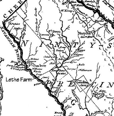
Dr. De La Howe was buried on the hill opposite to the dwelling on the plantation named by him "Lethe Farm." He requested a substantial brick wall should be built around his grave—not less than ten feet square, eight feet above the ground, with an iron door and lock, and that the following inscription, in large iron capitals, shall ever be kept encased: "Joes De La Howe, fundator, hipes Seminarie Agriculturalis," with date of his decease. (Source: Handbook of South Carolina, 2nd Edition by South Carolina Department of Agriculture (1908), pg 215.)
— Submitted December 18, 2009, by Brian Scott of Anderson, South Carolina.
Credits. This page was last revised on April 10, 2024. It was originally submitted on July 21, 2008, by Brian Scott of Anderson, South Carolina. This page has been viewed 2,043 times since then and 53 times this year. Photos: 1, 2. submitted on July 21, 2008, by Brian Scott of Anderson, South Carolina. 3. submitted on November 23, 2009, by Brian Scott of Anderson, South Carolina. • Kevin W. was the editor who published this page.

