Taylor in Wayne County, Michigan — The American Midwest (Great Lakes)
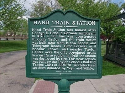
Hand Train Station
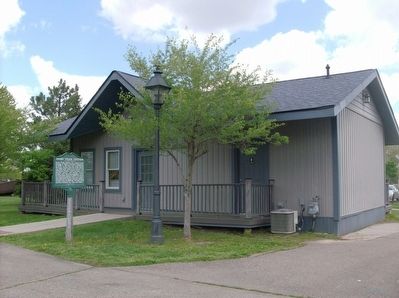
Hand Train Station was named after George E. Hand, a German immigrant. In 1876 a rail line was constructed through Taylor and the train station was built near what is now Ecourse and Telegraph Roads. Hand Corners, as it became known, and nearby Taylor Center were the only populated areas in a vast farm region. In 1965 the station was destroyed by fire. This near replica was built by the Taylor Schools Building Trades Class of 1990-91. Architectural services donated by Yops and Wilkie.
Erected 1993.
Topics. This historical marker is listed in this topic list: Railroads & Streetcars. A significant historical year for this entry is 1876.
Location. 42° 12.894′ N, 83° 15.084′ W. Marker is in Taylor, Michigan, in Wayne County. Marker can be reached from Pardee Road, 0.3 miles north of Northline Road. The Hand Train Station is located with the historical buildings at the southwest corner of Heritage Park. Touch for map. Marker is at or near this postal address: 12111 Pardee Road, Taylor MI 48180, United States of America. Touch for directions.
Other nearby markers. At least 8 other markers are within walking distance of this marker. Taylor Heritage School (here, next to this marker); Fitz's Caboose (a few steps from this marker); The Greenwald Herkimer House (within shouting distance of this marker); Water-Powered Mill (within shouting distance of this marker); Coan Lake (about 500 feet away, measured in a direct line); West Mound Church (about 500 feet away); Town Hall (about 600 feet away); The Log Cabin (about 600 feet away). Touch for a list and map of all markers in Taylor.

Photographed By Joel S., May 13, 2016
2. Hand Train Station and Marker at Heritage Park
City website entry
Click for more information.
Click for more information.
Credits. This page was last revised on May 14, 2022. It was originally submitted on May 25, 2016, by Joel Seewald of Madison Heights, Michigan. This page has been viewed 565 times since then and 37 times this year. Photos: 1, 2. submitted on May 25, 2016, by Joel Seewald of Madison Heights, Michigan.
