Ashland in Clay County, Alabama — The American South (East South Central)
Clay County and the Creek Indian War of 1813-14 / Clay County and the Creek Indian Confederacy
Side 1
Creek Indian War of 1813-14
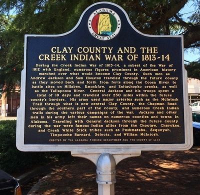
During the Creek Indian War of 1813-14, a subset of the War of 1812 with England, numerous figures prominent in American history marched over what would become Clay County. Such men as Andrew Jackson and Sam Houston traveled through the future county as they moved back and forth from forts along the Coosa River to battle sites on Hillabee, Emuckfaw, and Enitachopko creeks, as well as the Tallapoosa River. General Jackson and his troops spent a total of 18 days and traveled over 230 miles within the future county's borders. His army used major arteries such as the McIntosh Trail through what is now central Clay County, the Chapman Road through the southern part of the county, and numerous Creek Indian trails during the various campaigns of the war. Jackson and other men in his army left their names on numerous counties and towns in Alabama. Traveling with General Jackson through the future county during the war were famous Indian allies from the Choctaw, Cherokee, and Creek White Stick tribes such as Pushmataha, Sequoyah, Timpooche Barnard, Selocta, and William McIntosh.
Side 2
Creek Indian Confederacy
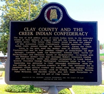
The loss of 22.5 million acres of Creek Indian lands in the surrender treaty of Fort Jackson in August 1814 left the Creeks with only 5.2 million acres. The future Clay County would be near the center of this downsized Creek Confederacy. Several important Creek Indian trails passed through the future county. Among the Creek Indian towns in the area where the mother town of Hillabee (near Pinckneyville) and its four satellite villages of Enitachopko (at Bluff Springs), Lanudshi Apala (at Millerville), Echoise Ligua (north of Hackneyville) and Oktasassi (south of Hackneyville). Co-located with the Hillabee mother town was Scotsman Robert Grierson's trading post and factory, which also played prominently in Creek Indian history. President George Washington's invitation letter to the Creek leadership was delivered to Chief Alexander McGillivray while he was visiting at the Grierson complex in 1790. This invitation led to America's initial contact and treaty with the Alabama Creeks. Other noted Red Stick Creeks , such as William Weatherford, Menawa, Peter McQueen, and Opithle Yahola, also left their footprints in the red soil of Clay County.
Erected 2013 by the Alabama Tourism Department and the County of Clay.
Topics. This historical marker is listed in these topic lists: Native Americans • Settlements & Settlers • Wars, US Indian • Waterways & Vessels. A significant historical month for this entry is August 1814.
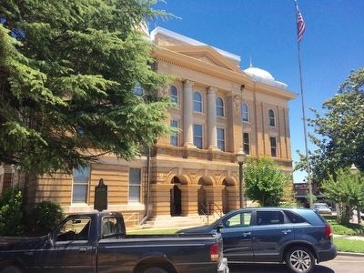
Location. 33° 16.444′ N, 85° 50.153′ W. Marker is in Ashland, Alabama, in Clay County. Marker is at the intersection of Court Square (Alabama Route 9) and 1st Avenue North, on the right when traveling west on Court Square. Located on the grounds of the Clay County Courthouse. Touch for map. Marker is at or near this postal address: 25 Court Square, Ashland AL 36251, United States of America. Touch for directions.
Other nearby markers. At least 8 other markers are within 6 miles of this marker, measured as the crow flies. Clay County Veterans Memorial (a few steps from this marker); Clay County / Clay County Courthouse (within shouting distance of this marker); Ashland, Alabama (within shouting distance of this marker); First Baptist Church of Ashland (approx. half a mile away); John Richmond McCain (approx. 5.2 miles away); Lineville Alabama Monument (approx. 5.3 miles away); History of Lineville (approx. 5.4 miles away); Lineville First United Methodist Church (approx. 5.4 miles away). Touch for a list and map of all markers in Ashland.
Related markers. Click here for a list of markers that are related to this marker.
Also see . . . Wikipedia article on the Creek Indian War. (Submitted on June 8, 2016, by Mark Hilton of Montgomery, Alabama.)
Credits. This page was last revised on June 16, 2016. It was originally submitted on June 8, 2016, by Mark Hilton of Montgomery, Alabama. This page has been viewed 1,276 times since then and 113 times this year. Photos: 1, 2, 3. submitted on June 8, 2016, by Mark Hilton of Montgomery, Alabama.


