Atiquizaya, Ahuachapán, El Salvador — Central America (West Coast)
Salvador Antonio Gómez Góchez
"The Day of the Salvadoran"
United Salvadoran Communities (Unicomdes – USA)
Iniciativa Ciudadana Ahuachapeneca (ICA) y Fundacion Ahuachapaneca de Desarrollo Comunitario (FADECO)
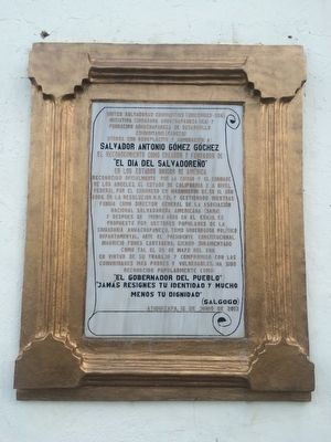
otorga con beneplácito y admiración a: Salvador Antonio Gómez Góchez el reconocimiento como creador y fundador de: “El Dia del Salvadoreño” en los Estados Unidos de América reconocido oficialmente por la ciudad y el condado de Los Angeles, el estado de California y, a nivel federal por el Congreso en Washington D.C. En el año 2006, en la resolución H.R. 721, y gestionado mientras fungia como Director General de la Asociación Nacional Salvadoreña Americana (Sana), y despues de treinta años en el exilio, es propuesto por sectores populares de la ciudadania ahuachapeneca, como Gobernador político departmental, ante el Presidente Constitucional Mauricio Funes Cartagena, siendo juramentado como tal el 25 de mayo de 2011, en virtud de su trabajo y compromiso con las comunidades más pobres y vulnerables, ha sido reconocido popularmente como: “El Gobernador del Pueblo”
“Jamás resignes tu identidad y mucho menos tu dignidad”
(Salgogo)
Atiquizaya, 15 de junio de 2013
United Salvadoran Communities (Unicomdes - USA)
Ahuachapeneca Citizen Initiative (ICA) and the Ahuachapaneca Community Development Foundation (FADECO) give with appreciation and admiration to: Salvador Antonio Gómez Góchez recognition as creator and founder of: "The Day of the Salvadoran" in the United States of America officially recognized by the city and county of Los Angeles, California and at the federal level by Congress in Washington, DC in 2006, through H.R. 721, all while serving as Director General of the National American Salvadoran Association (Sana), and after thirty years in exile, was proposed by popular sectors of the citizens of Ahuachapán as departmental Governor in the period of Constitutional President Mauricio Funes Cartagena being sworn in as such on May 25, 2011, by virtue of his work and commitment to the poorest and most vulnerable communities he has become popularly known as "Governor of the People"
"Never forget your identity and much less your dignity”
(Salgogo)
Atiquizaya, June 15, 2013
Erected 2013.
Topics. This historical marker is listed in this topic list: Government & Politics. A significant historical date for this entry is May 25, 2011.
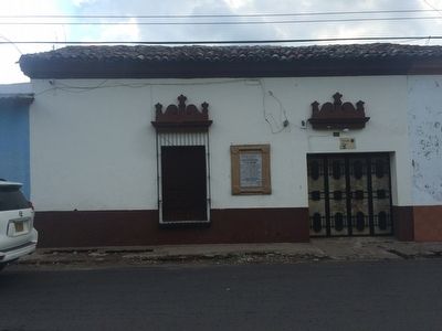
Location. 13° 58.49′ N, 89° 45.435′ W. Marker is in Atiquizaya, Ahuachapán. Marker is on Avenidad
5 de Noviembre Sur close to 1a Calle Poniente. Touch for map. Marker is in this post office area: Atiquizaya, Ahuachapán 01203, El Salvador. Touch for directions.
Other nearby markers. At least 8 other markers are within 23 kilometers of this marker, measured as the crow flies. First Century of the City of Atiquizaya (about 210 meters away, measured in a direct line); 200th Anniversary of the First Cry of Salvadoran Independence (about 210 meters away); Dr. Stanley Boggs (approx. 9 kilometers away in Santa Ana); Ernesto "Che" Guevara's Visit to El Salvador (approx. 9 kilometers away in Santa Ana); Here Died General Justo Rufino Barrios (approx. 9.1 kilometers away in Santa Ana); The Ataco Catholic Church and 2001 Earthquake (approx. 15.4 kilometers away); Nahuizalco (approx. 21.6 kilometers away in Sonsonate); Oscar Arnulfo Romero (approx. 21.7 kilometers away in Sonsonate). Touch for a list and map of all markers in Atiquizaya.
Credits. This page was last revised on April 2, 2023. It was originally submitted on June 19, 2016, by J. Makali Bruton of Accra, Ghana. This page has been viewed 445 times since then and 23 times this year. Photos: 1, 2. submitted on June 19, 2016, by J. Makali Bruton of Accra, Ghana.

