Near Prestonsburg in Floyd County, Kentucky — The American South (East South Central)
The Union Assault
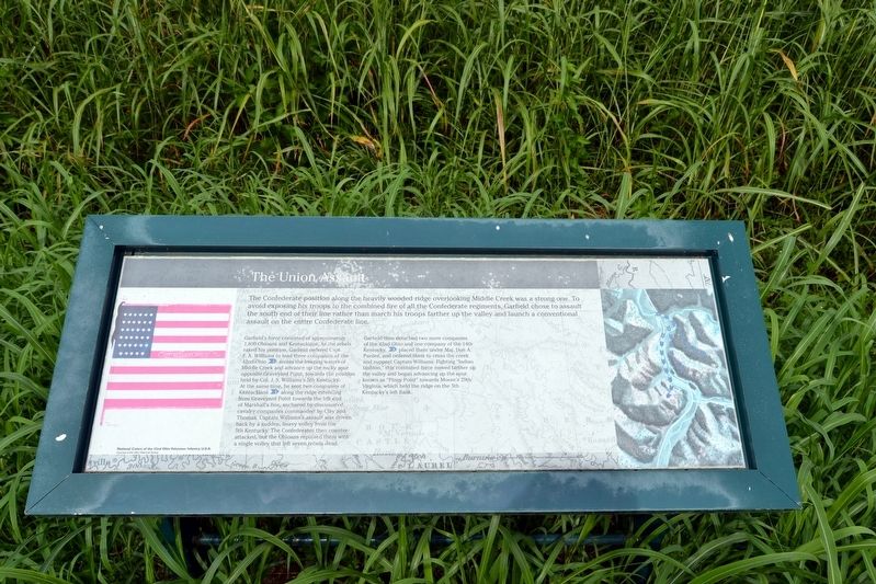
Garfield’s forces consisted of approximately 1,800 Ohioans and Kentuckians. As the rebels raked his position, Garfield ordered Capt. F.A. Williams to lead three companies of the 42nd Ohio (1) across the freezing waters of Middle Creek and advance up the rocky spur opposite Graveyard Point, towards the position held by Col. J.S. Williams’s 5th Kentucky. At the same time, he sent two companies of Kentuckians (2) along the ridge extending from Graveyard Point towards the left end of Marshall’s line, anchored by dismounted cavalry companies commanded by Clay and Thomas. Captain Williams’s assault was driven back by a sudden, heavy volley from the 5th Kentucky. The Confederates then counter-attacked, but the Ohioans repulsed them with a single volley that left seven rebels dead.
Garfield then detached two more companies of the 42nd Ohio and one company of the 14th Kentucky, (3) placed them under Maj. Don A. Pardee, and ordered them to cross the creek and support Captain Williams. Fighting “Indian fashion,” this combined force moved farther up the valley and began advancing up the spur known as “Piney Point” towards Moore’s 29th Virginia, which held the ridge on the 5th Kentucky’s left flank.
Topics. This historical marker is listed in this topic list: War, US Civil. A significant historical date for this entry is January 10, 1862.
Location. 37° 39.077′ N, 82° 48.709′ W. Marker is near Prestonsburg, Kentucky, in Floyd County. Marker can be reached from State Highway 114, 0.1 miles east of State Highway 404. Marker is located on the Union Trail at the Middle Creek National Battlefield; the above directions are to the battlefield parking area. Touch for map. Marker is in this post office area: Prestonsburg KY 41653, United States of America. Touch for directions.
Other nearby markers. At least 8 other markers are within walking distance of this marker. The Union Command Post (within shouting distance of this marker); Monroe's Bayonet Charge Wins the Battle (about 300 feet away, measured in a direct line); A Desperate Fight, but Few Casualties (about 500 feet away); The Battle of Middle Creek / The Fitzpatrick Farm (about 500 feet away); The Battle of Middle Creek (about 600 feet away); Eastern Kentucky's Civil War Battles and Skirmishes, 1863-1864 (about 600 feet away); Why They Fought Here (about
600 feet away); Eastern Kentucky's Civil War Battles and Skirmishes, 1861-1862 (about 600 feet away). Touch for a list and map of all markers in Prestonsburg.
More about this marker. The marker includes the National Colors of the 42nd Ohio Volunteer Infantry, U.S.A. and a map of the Union assault keyed to the marker text.
Also see . . . Middle Creek National Battlefield. Official website of the Middle Creek National Battlefield Foundation. (Submitted on September 7, 2016.)
Credits. This page was last revised on September 7, 2016. It was originally submitted on September 7, 2016, by Duane Hall of Abilene, Texas. This page has been viewed 233 times since then and 9 times this year. Photos: 1, 2, 3, 4. submitted on September 7, 2016, by Duane Hall of Abilene, Texas.


