Near Spotsylvania Courthouse in Spotsylvania County, Virginia — The American South (Mid-Atlantic)
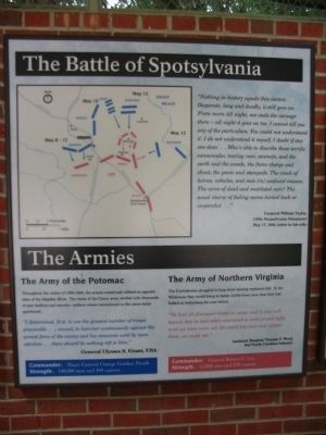
The Battle of Spotsylvania
Spotsylvania Exhibit Shelter
— West Wall —
Corporal William Taylor
110th Pennsylvania Volunteers
May 17, 1864, letter to his wife
The Armies
The Army of the Potomac
Throughout the winter of 1863-1864, the armies rested and refitted on opposites sides of the Rapidan River. The ranks of the Union army swelled with thousands of new draftees and recruits - soldiers whose commitment to the cause many questioned.
"I determined, first, to use the greatest number of troops practicable...; second, to hammer continuously against the armed force of the enemy and his resources until by mere attrition...there would be nothing left to him."
General Ulysses S. Grant, USA
Commander: Major General George Gordon Meade
Strength: 100,000 men and 344 cannon
The Army of Northern Virginia
The Confederates struggled to keep their existing regiments full. In the Wilderness they would bring to the battle 13,000 fewer men than they had fielded at Gettysburg the year before.
"We had all discussed Grant in camp, and it was well known that he had taken command to hold on and fight until we were worn out. He could lose men and replace them, we could not."
Assistant Surgen Thomas F. Wood,
3rd North Carolina Infantry
Commander: General Robert E. Lee
Strength: 55,000 men and 228 cannon
Topics and series. This historical marker is listed in this topic list: War, US Civil. In addition, it is included in the Battlefield Trails - Civil War series list. A significant historical month for this entry is May 1847.
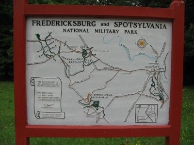
Location. 38° 13.149′ N, 77° 36.863′ W. Marker is near Spotsylvania Courthouse, Virginia, in Spotsylvania County. Marker is on Grant Drive, 0.1 miles north of Brock Road (County Route 613), on the left when traveling south. Located at stop one (The Exhibit Shelter) on the driving tour of Spotsylvania Battlefield unit of the Fredericksburg and Spotsylvania National Military Park. Touch for map. Marker is at or near this postal address: 9550 Grant Dr, Spotsylvania VA 22553, United States of America. Touch for directions.
Other nearby markers. At least 8 other markers are within walking distance of this marker. Grant Finds an Opening: May 12 (here, next to this marker); Testing the Line: May 8-10
(here, next to this marker); No Turning Back (here, next to this marker); A Different Kind of War (here, next to this marker); Spotsylvania Court House (a few steps from this marker); The Death of Sedgwick (about 400 feet away, measured in a direct line); Spotsylvania Campaign (about 400 feet away); a different marker also named Spotsylvania Campaign (about 400 feet away). Touch for a list and map of all markers in Spotsylvania Courthouse.
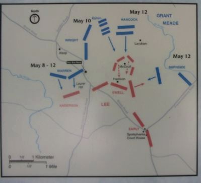
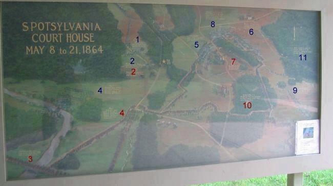
More about this marker. In the upper portion of the marker, to the left of the quote from Private Taylor, is a map showing the major actions of the battle.
Also see . . .
1. The Exhibit Shelter. National Park Service website entry (Submitted on August 24, 2008, by Craig Swain of Leesburg, Virginia.)
2. Spotsylvania: Tour Stop One Markers. Includes the Shelter exhibits and markers on nearby trails. (Submitted on September 12, 2008, by Craig Swain of Leesburg, Virginia.)
3. Spotsylvania: Tour Stop Two Markers. Covering Upton's Attack trail. (Submitted on September 12, 2008, by Craig Swain of Leesburg, Virginia.)
4. Spotsylvania: Tour Stop Three Markers
Photographed By Craig Swain, July 6, 2008
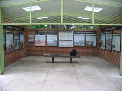
3. The Spotsylvania Exhibit Shelter
To the left is the south wall, with the A Different Kind of War marker. In the center are the Testing the Line: May 8-10, The Battle of Spotsylvania, and Grant Finds and Opening: May 12 markers along the west wall. To the right is the north wall with No Turning Back.
5. Spotsylvania: Tour Stop Four and Five Markers. Covering the Harrison and McCoull Houses as well as Lee's final line. (Submitted on September 12, 2008, by Craig Swain of Leesburg, Virginia.)
6. Spotsylvania: Tour Stop Six and Seven Markers. Covers the East side of the Salient out to Heth's Salient. (Submitted on September 12, 2008, by Craig Swain of Leesburg, Virginia.)
7. Spotsylvania: Tour Stops Outside the Park. Covering the town of Spotsylvania Court House. (Submitted on September 12, 2008, by Craig Swain of Leesburg, Virginia.)
8. Spotsylvania: Tour Stop - Battle of Harris Farm. The last action in the Spotsylvania Campaign. (Submitted on September 12, 2008, by Craig Swain of Leesburg, Virginia.)
Photographed By Craig Swain
5. The Battle of Spotsylvania Painting
(Double click photo to enlarge.) Located just in front of the Exhibit Shelter. Note the gold star in the center of the painting indicating the shelter location. The large blue and red numbers are superimposed to indicate the location of the following important phases of the battle:
Blue 1 - May 8, 1864 Warren's Union V Corps supports the Cavalry.
Blue 2 - Sheridan's Union Cavalry leads the advance during the evening of May 7-8.
Red 2 - Fitzhugh Lee's Confederate cavalry contests the Union move all night.
Red 3 - Confederate Gen. Anderson's Corps arrives early May 8, 1864 after an all night march.
Blue 4 - Hancock's Union II Corps and Heth's Confederate division engage in flanking operations.
Red 4 - Anderson's men arrive on the run as Federals nearly breakthrough. Confederates immediately build earthworks.
Blue 5 - May 10, 1864 Union Colonel Emory Upton leads 12 regiments to a local success.
Blue 6 - May 12. A huge early morning Federal assault overwhelms an unprepared segment of Lee's Forces.
Red 7 - Lee personally leads the effort to halt the Federal attack.
Blue 8 - Federal reinforcements were held up at the earthworks where hand to hand fighting raged in the rain for 20 hours at the Bloody Angle.
Blue 9 - May 12 and 16. Burnside's II Federal Corps attacks but is easily repulsed.
Red 10 - Evening of May 12-15. The Harrison House line constructed. On May 16, massed common drive of a Federal attack.
Blue 11 - Grant, unable to break Lee's position, moves on to the southwest, ending two weeks of heavy fighting.
Credits. This page was last revised on December 16, 2022. It was originally submitted on August 24, 2008, by Craig Swain of Leesburg, Virginia. This page has been viewed 3,853 times since then and 20 times this year. Photos: 1, 2, 3, 4, 5. submitted on August 24, 2008, by Craig Swain of Leesburg, Virginia.
