Automated Lock / Une écluse automatique
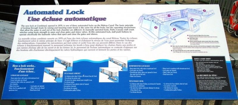
The new lock at Combined, opened in 1974, is one of three automated locks on the Rideau Canal. The basic principle of locking through boats by raising and lowering water levels is the same for all the locks, but the operating mechanisms that allow the water in and out of the lock chamber are different. In manually operated locks, Parks Canada staff crank winches using brute strength to open and close gates and sluice valves. At this automated lock, staff push buttons to operate electrically the hydraulic valves that open and close the gates and sluices.
How a lock works...
UPBOUND LOCKAGE
• Boat enters lock, with water at downstream level.
• Lower lock gates are closed.
• Upstream sluice valves are opened to fill lock chamber.
• Water level rises
• Water level is equalized with upstream level.
• Lock gates are opened.
• Sluice valves are closed.
• Boat leaves lock.
DOWNBOUND LOCKAGE
• Boat enters lock, with water at upstream level.
• Lock gates are closed.
• Downstream sluice valves are opened to lower the water level in the lock.
• Water level
• Water level is equalized with downstream level.
• Lock gates are opened.
• Sluice valves are closed.
• Boat leaves lock.
[Upper right canal lock diagram legend]
1 26 foot (8 metre) lift. Highest lift on the system.
2 Solid Timber Gates.
3 Electric powered hydraulic systems operate sluice valves and gates.
4 Water enters the chamber through many holes in the floor of the lock that are designed to reduce turbulence.
5 Air escapes through this vent as water travels the tunnel below.
HAVE A SAFE VISIT!
[not transcribed]
—————————————————
Fonctionnement d'une écluse...
ÉCLUSAGE AMONT
• Le niveau de l'eau atteint celui de l'amont.
ÉCLUSAGE AVAL
• Le niveau de l'eau atteint celui de l'aval.
[Légende du diagramme de verrouillage du canal supérieur droit]
LA
SÉCURITÉ EN TÊTE!
• Le bateau entre dans l'écluse, au niveau d'eau de l'aval.
• On referme les portes aval.
• On ouvre les vannes amont pour remplir le sas.
• Le niveau monte.
• Les portes s'ourvent.
• On referme les vannes.
• L'embarcation quitte l'écluse.
• Le bateau entre dans l'écluse, au niveau de l'amont.
• Les portes se referment.
• On ouvre les vannes aval pour abaisser le niveau d'eau des le sas.
• Le niveau descend.
• Les portes s'ouvrent.
• On referme les vannes.
• L'embarcation quitte l'écluse.
1 Élévation de 26 pieds (8 mètres). L'écluse la plus haute du réseau.
2 Portes de madriers.
3 Des systèmes hydrauliques mus à l'électricité actionnent des portes et les vannes d'écluse.
4 L'eau pénètre dans le sas par de nombreux orifices ménagés dans le plancher de l'écluse et conçus pour réduire le turbulence.
5 L'air s'échappe par cet évent alors que l'eau emprunte la canalisation plus bas.
[non transcrit]
Erected by Parks/Parcs Canada.
Topics. This historical marker is listed in these topic lists: Man-Made Features • Parks & Recreational Areas • Waterways & Vessels. A significant historical year for this entry is 1974.
Location. 44° 53.824′ N, 76° 1.231′ W. Marker is in Smiths Falls, Ontario, in Lanark County. Marker is on Beckwith Street South (Provincial Highway 15) just south of Canal Street, on the right when traveling south. Marker is at Smith Falls Combined Lockstation Lock 29a. Touch for map. Marker is at or near this postal address: 34 Beckwith Street South, Smiths Falls ON K7A 2A8, Canada. Touch for directions.
Other nearby markers. At least 8 other markers are within walking distance of this marker. Rotary Club Swimming Pool Stone / La pierre de la piscine du club Rotary (a few steps from this marker); Smiths Falls (within shouting distance of this marker); The underwater view / La vue sous l'eau (within shouting distance of this marker); Welcome to Combined Locks (within shouting distance of this marker); Crossroads of the Rideau / À la croisée des chemins (within shouting distance of this marker); War Memorial (within shouting distance of this marker); To Commemorate the Opening of the Rideau Canal 1832 (within shouting distance of this marker); HMCS/MHCS Smiths Falls (within shouting distance of this marker). Touch for a list and map of all markers in Smiths Falls.
Also see . . .
1. Rideau Canal National Historic Site. (Submitted on October 29, 2018, by William Fischer, Jr. of Scranton, Pennsylvania.)
2. Rideau Canal - Behind the Scenes: How a Lock Works. (Submitted on October 29, 2018, by William Fischer, Jr. of Scranton, Pennsylvania.)
Credits. This page was last revised on October 29, 2018. It was originally submitted on October 29, 2018, by William Fischer, Jr. of Scranton, Pennsylvania. This page has been viewed 176 times since then and 10 times this year. Photos: 1, 2. submitted on October 29, 2018, by William Fischer, Jr. of Scranton, Pennsylvania.

