Adams Morgan in Northwest Washington in Washington, District of Columbia — The American Northeast (Mid-Atlantic)
"Suburban" Development
Roads to Diversity
— Adams Morgan Heritage Trail —
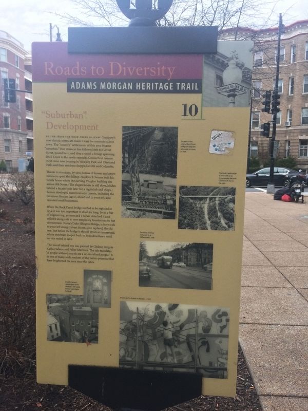
By the 1890s the Rock Creek Railway Company's new electric streetcars made it easy to commute across town. The "country" settlements of this area became "suburban." One streetcar line followed 18th to Calvert Street, passed here, and then crossed a bridge spanning Rock Creek to the newly extended Connecticut Avenue. Next came new housing in Woodley Park and Cleveland Park, and their residents shopped at 18th and Columbia.
Thanks to streetcars, by 1900 dozens of houses and apartments occupied this hilltop. Franklin T. Sanner built his family home where the curving L'Aiglon building sits across 18th Street. (The elegant house is still there, hidden behind a façade built later for a nightclub and shops.) Sanner developed numerous apartments, including the luxurious Beacon (1910), ahead and to your left, and recruited small businesses.
When the Rock Creek bridge needed to be replaced in 1934, it was too important to close for long. So in a feat of engineering, 40 men and 5 horses detached it and rolled it along rails to new temporary foundations 80 feet downstream. Today's Duke Ellington Bridge, a short walk to your left along Calvert Street, soon replaced the old one. Just before the bridge is the old streetcar turnaround, where streetcars looped back to head downtown until service ended in 1962.
The mural behind you was painted by Chilean émigrés Carlos Salazar and Felipe Martinez. The tile translates: "A people without murals are a de-muralized people." It is one of many such markers of the Latino presence that have brightened the area since the 1960s.
Erected 2005 by Cultural Tourism DC. (Marker Number 10.)
Topics and series. This historical marker is listed in these topic lists: Railroads & Streetcars • Settlements & Settlers. In addition, it is included in the Adams Morgan Heritage Trail series list. A significant historical year for this entry is 1900.
Location. 38° 55.403′ N, 77° 2.6′ W. Marker is in Northwest Washington in Washington, District of Columbia. It is in Adams Morgan. Marker is at the intersection of Adams Mill Road Northwest and Lanier Place Northwest, on the right when traveling west on Adams Mill Road Northwest. Touch for map. Marker is at or near this postal address: 1827 Adams Mill Road Northwest, Washington DC 20009, United States of America. Touch for directions.
Other nearby markers. At least 8 other markers are within walking distance of this marker. A People Without Murals Is A Demuralized People (within shouting distance of this marker); Tragedy at 18th and Columbia (within shouting distance of this marker); Walter Pierce Park (about 400 feet away, measured in a direct line); Serving the Neighborhood (about 400 feet away); The Artistic Life
Credits. This page was last revised on January 30, 2023. It was originally submitted on January 13, 2018, by Devry Becker Jones of Washington, District of Columbia. This page has been viewed 279 times since then and 28 times this year. Last updated on March 7, 2019, by Devry Becker Jones of Washington, District of Columbia. Photos: 1, 2, 3. submitted on January 13, 2018, by Devry Becker Jones of Washington, District of Columbia. • Bill Pfingsten was the editor who published this page.


