Near Dearing in McDuffie County, Georgia — The American South (South Atlantic)
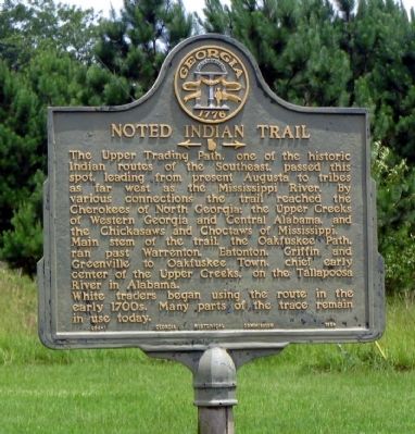
Noted Indian Trail
Main stem of the trail, the Oakfuskee Path, ran past Warrenton, Eatonton, Griffin and Greenville to Oakfuskee Town, chief early center of the Upper Creeks, on the Tallapoosa River in Alabama.
White traders began using the route in the early 1700’s. Many parts of the trace remain in use today.
Erected 1954 by Georgia Historical Commission. (Marker Number 094-1.)
Topics and series. This historical marker is listed in these topic lists: Colonial Era • Native Americans • Roads & Vehicles. In addition, it is included in the Georgia Historical Society series list.
Location. 33° 25.126′ N, 82° 25.627′ W. Marker is near Dearing, Georgia, in McDuffie County. Marker is at the intersection of Augusta Highway (U.S. 278) and Ellington Airline Road, on the right when traveling east on Augusta Highway. Touch for map. Marker is in this post office area: Dearing GA 30808, United States of America. Touch for directions.
Other nearby markers. At least 8 other markers are within 6 miles of this marker, measured as the crow flies. The Birthplace of George McDuffie (approx. 2.2 miles away); John Smith Watson Homeplace (approx. 3.4 miles away); Women of the Sixty's Confederate Monument (approx. 5.4 miles away); Blind Willie McTell (approx. 5.4 miles away); Usry House (approx. 5.6 miles away); Woodman of the World Supreme Sacrifice Monument (approx. 5.7 miles away); VFW Post 6672 KIA Monument (approx. 5.7 miles away); VFW Veterans Monument (approx. 5.7 miles away).
Credits. This page was last revised on June 16, 2016. It was originally submitted on February 9, 2009, by David Seibert of Sandy Springs, Georgia. This page has been viewed 1,370 times since then and 38 times this year. Photo 1. submitted on February 9, 2009, by David Seibert of Sandy Springs, Georgia. • Kevin W. was the editor who published this page.
Editor’s want-list for this marker. A wide shot of the marker and its surroundings. • Can you help?
