Jackson in Butts County, Georgia — The American South (South Atlantic)
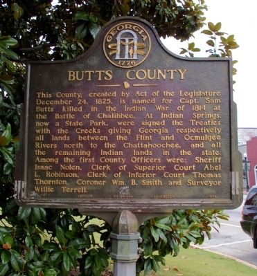
Butts County
Erected 1954 by Georgia Historical Commission. (Marker Number 018-1.)
Topics and series. This historical marker is listed in these topic lists: Government & Politics • Native Americans • Political Subdivisions. In addition, it is included in the Georgia Historical Society series list. A significant historical date for this entry is December 24, 1825.
Location. 33° 17.671′ N, 83° 58.029′ W. Marker is in Jackson, Georgia, in Butts County. Marker is at the intersection of West 3rd Street (U.S. 23) and Oak Street, on the right when traveling west on West 3rd Street. The marker is at the edge of the lawn of the Butts County Courthouse. Touch for map. Marker is in this post office area: Jackson GA 30233, United States of America. Touch for directions.
Other nearby markers. At least 8 other markers are within 5 miles of this marker, measured as the crow flies. The Right Wing at Jackson (a few steps from this marker); Crossing the Ocmulgee (within shouting distance of this marker); Jackson (within shouting distance of this marker); Butts County Confederate Monument (within shouting distance of this marker); Sylvan Grove Plantation (approx. 0.9 miles away); a different marker also named Sylvan Grove Plantation (approx. 0.9 miles away); Iron Springs (approx. 3˝ miles away); “Idlewilde” (approx. 4.1 miles away). Touch for a list and map of all markers in Jackson.
Credits. This page was last revised on May 10, 2017. It was originally submitted on August 4, 2009, by David Seibert of Sandy Springs, Georgia. This page has been viewed 1,356 times since then and 27 times this year. Photos: 1, 2. submitted on August 4, 2009, by David Seibert of Sandy Springs, Georgia. • Craig Swain was the editor who published this page.

