Rocheport in Boone County, Missouri — The American Midwest (Upper Plains)
Edward D. "Ted" and Pat Jones
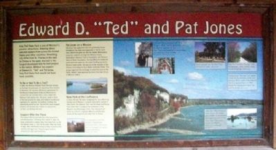
Katy Trail State Park is one of Missouri's premier attractions, drawing about 400,000 visitors from across the United States and other countries. Stretching 225 miles from St. Charles in the east to Clinton in the west, the trail is the longest developed rails-to-trail project in the nation. Without the support of Edward D. "Ted" and Pat Jones, Katy Trail State Park would not have been possible.
To Be or Not To Be a Trail?
In 1986, the Missouri-Kansas-Texas Railroad (known as the Katy) discontinued rail operations from Sedalia to Machens. The decision offered an opportunity for the Missouri Department of Natural Resources to convert the rail corridors into a trail, under the National Trails System Act. Ted Jones spoke in favor of the trail around the state, and lobbied the Missouri legislature for approval. But without funding, the opportunity would be lost. Ted and Pat Jones stepped forward and donated $2.2 million to acquire the corridor and develop the trail.
Support After the Flood
The support did not end with the initial acquisition and development. Following Ted's death in 1990, Pat Jones continued to support Katy Trail State Park, as did the Edward Jones Co. that Ted founded. After the flood of 1993, they contributed money to help reconstruct the severely damaged trail. They also gave funds to produce full-color trail brochures.
Pat Jones on a Mission
Pat Jones has supported trail and greenway issues throughout the state and especially in the St. Louis area, where she grew up. She has helped Missourians enjoy the outdoors through the Missouri Parks Association, Missouri Prairie Foundation and Missouri Rails-to-Trails Foundation. During efforts to renew the parks-and-soils sales tax, the major funding source for Missouri state parks, she was an active member of the Citizens Committee for Soil, Water and State Parks. This group organized the campaign to place the issue on the ballot, where it was approved by more than two-thirds of Missouri voters.
New Park at the Confluence
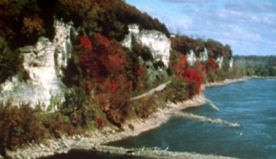
In 2002, Pat and Ted were recognized for their efforts by having one of Missouri's newest state parks named in their honor. The Edward "Ted" and Pat Jones-Confluence Point State Park is located at the confluence of the Missouri and Mississippi rivers. The new park will serve as a link in a regional effort to provide trail access all the way from the Katy Trail to Illinois.
Erected by Missouri Department of Natural Resources.
Topics and series. This historical marker is listed in these topic lists: Charity & Public Work • Environment
• Railroads & Streetcars • Roads & Vehicles. In addition, it is included in the Katy Trail State Park series list. A significant historical year for this entry is 1986.
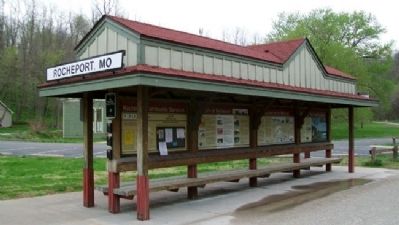
Location. 38° 58.65′ N, 92° 33.651′ W. Marker is in Rocheport, Missouri, in Boone County. Marker kiosk is adjacent to the former railroad passenger depot, along the Katy Trail State Park, and about 300 feet ESE of the intersection of Pike and 1st Streets. Touch for map. Marker is in this post office area: Rocheport MO 65279, United States of America. Touch for directions.
Other nearby markers. At least 8 other markers are within 10 miles of this marker, measured as the crow flies. Steamboating on the Missouri (here, next to this marker); Katy Trail State Park 20th Anniversary (here, next to this marker); History of Rocheport (here, next to this marker); Boonville (approx. 8.6 miles away); Hannah Cole's Fort (approx. 9.2 miles away); The Battle of Boonville (approx. 9.3 miles away); a different marker also named Battle of Boonville (approx. 9.3 miles away); Santa Fe Trail (approx. 9.7 miles away). Touch for a list and map of all markers in Rocheport.
Also see . . .
1. Katy Trail State Park. (Submitted on August 22, 2011, by William Fischer, Jr. of Scranton, Pennsylvania.)
2. Pat Jones. (Submitted on August 22, 2011, by William Fischer, Jr. of Scranton, Pennsylvania.)
3. Edward Jones
. (Submitted on August 22, 2011, by William Fischer, Jr. of Scranton, Pennsylvania.)
Credits. This page was last revised on June 16, 2016. It was originally submitted on August 22, 2011, by William Fischer, Jr. of Scranton, Pennsylvania. This page has been viewed 1,398 times since then and 23 times this year. Photos: 1, 2, 3. submitted on August 22, 2011, by William Fischer, Jr. of Scranton, Pennsylvania.


