Cascade in El Paso County, Colorado — The American Mountains (Southwest)
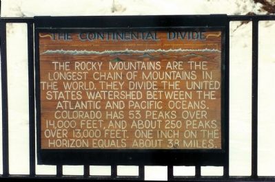
The Continental Divide
Inscription.
The Rocky Mountains are the longest chain of mountains in the world. They divide the United States watershed between the Atlantic and Pacific Oceans. Colorado has 53 peaks over 14,000 feet. One inch on the Horizon equals about 38 miles.
Topics. This historical marker is listed in these topic lists: Exploration • Natural Features • Natural Resources.
Location. 38° 50.431′ N, 105° 2.504′ W. Marker is near Cascade, Colorado, in El Paso County. Marker is on Pikes Peak Hwy. Located at the summit of Pikes Peak. Touch for map. Marker is in this post office area: Cascade CO 80809, United States of America. Touch for directions.
Other nearby markers. At least 8 other markers are within 3 miles of this marker, measured as the crow flies. Zebulon Montgomery Pike (here, next to this marker); Pike's Peak (a few steps from this marker); Commemorating the 100th Anniversary of the Inspiration of America the Beautiful (within shouting distance of this marker); A Look From The Top (approx. 0.7 miles away); Race to the Clouds (approx. 3 miles away); From Carriages to Corvettes (approx. 3 miles away); Amazing Pikes Peak Feats (approx. 3 miles away); Don’t kill them with kindness (approx. 3 miles away).
Also see . . . Wikipedia entry for Continental Divide. A continental divide is a line of elevated terrain which forms a border between two watersheds such that water falling on one side of the line eventually travels to one ocean or body of water, and water on the other side travels to another, generally on the opposite side of the continent. (Submitted on January 20, 2008, by Mike Stroud of Bluffton, South Carolina.)
Additional commentary.
1. Continential Divide
The divide runs along the crest of the Rockies, from British Columbia, through the United States, and continues southward into Mexico and Central America. It divides the continent's principal drainage into that flowing eastward (to the Hudson Bay in Canada or to the Mississippi River) and that flowing westward (to the Pacific Ocean).
— Submitted January 20, 2008, by Mike Stroud of Bluffton, South Carolina.

June 30, 2007
5. Manitou and Pikes Peak Railroad cars.
Click for more information.
Credits. This page was last revised on February 7, 2023. It was originally submitted on January 20, 2008, by Mike Stroud of Bluffton, South Carolina. This page has been viewed 9,096 times since then and 139 times this year. Photos: 1, 2, 3, 4. submitted on January 20, 2008, by Mike Stroud of Bluffton, South Carolina. 5, 6. submitted on January 21, 2008, by Kevin W. of Stafford, Virginia. • Kevin W. was the editor who published this page.
