Truckee in Nevada County, California — The American West (Pacific Coastal)
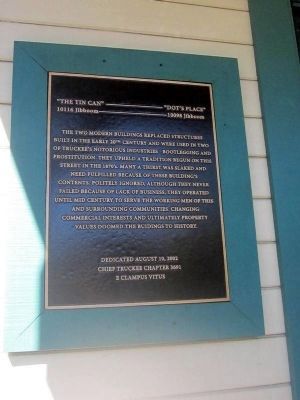
“The Tin Can” ----------- “Dot’s Place”
10116 Jibboom –----------------- 10098 Jibboom
Erected 2002 by Chief Truckee Chapter 3691, E Clampus Vitus.
Topics and series. This historical marker is listed in this topic list: Industry & Commerce. In addition, it is included in the E Clampus Vitus series list.
Location. 39° 19.735′ N, 120° 11.107′ W. Marker is in Truckee, California, in Nevada County. Marker is on Jibboom Street, on the right when traveling west. The marker is mounted on the front of the building located at 10098 Jibboom Street. Touch for map. Marker is in this post office area: Truckee CA 96161, United States of America. Touch for directions.
Other nearby markers. At least 8 other markers are within walking distance of this marker. Truckee’s Old Stone Garage and Site of Town’s First Dwelling (within shouting distance of this marker); First Log Cabin (about 400 feet away, measured in a direct line); Theodore Dehone Judah (about 500 feet away); First Transcontinental Railroad - Truckee (about 500 feet away); Old Truckee Jail (about 600 feet away); Jax Truckee Diner (about 700 feet away); Truckee (about 700 feet away); George Schaffer House (about 700 feet away). Touch for a list and map of all markers in Truckee.

Photographed By Syd Whittle, October 13, 2012
2. “The Tin Can” ----------- “Dot’s Place” Marker
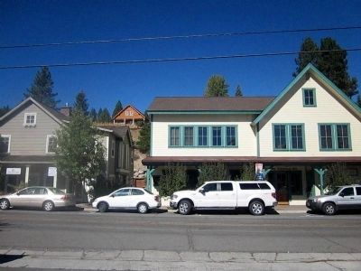
The 10116 Jibboom site is where the smaller building on the left is seen and the 10098 Jibboom site is where the larger building on the right is located. The marker is mounted on the left front of the larger building.
Credits. This page was last revised on June 16, 2016. It was originally submitted on November 5, 2012, by Syd Whittle of Mesa, Arizona. This page has been viewed 677 times since then and 20 times this year. Photos: 1, 2, 3. submitted on November 5, 2012, by Syd Whittle of Mesa, Arizona.

