Near Mountain Home in Baxter County, Arkansas — The American South (West South Central)
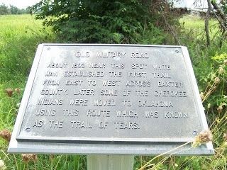
Old Military Road
Topics and series. This historical marker is listed in this topic list: Roads & Vehicles. In addition, it is included in the Trail of Tears series list. A significant historical year for this entry is 1800.
Location. 36° 17.395′ N, 92° 19.575′ W. Marker is near Mountain Home, Arkansas, in Baxter County. Marker is at the intersection of County Route 69 and County Route 55, on the right when traveling south on County Route 69. The marker is located approximately five (5) miles South of Mountain Home, Arkansas. Take State Highway 5 South to the intersection of Baxter CR 69. Turn right on Baxter CR 69. The marker is in the Hart Cemetery about 100 yards on the right after turning off State Highway 5. Touch for map. Marker is in this post office area: Mountain Home AR 72653, United States of America. Touch for directions.
Other nearby markers. At least 8 other markers are within 16 miles of this marker, measured as the crow flies. Mountain Home Cemetery (approx. 4.2 miles away); Mountain Home Commercial Historic District (approx. 4˝ miles away); Skirmishes Near Mountain Home (approx. 4˝ miles away); Jacob Wolf House (approx. 5.9 miles away); a different marker also named Jacob Wolf House (approx. 5.9 miles away); Jacob Wolf House Historic Site (approx. 5.9 miles away); a different marker also named Jacob Wolf House (approx. 5.9 miles away); City Hall (approx. 15.7 miles away). Touch for a list and map of all markers in Mountain Home.
More about this marker. The marker is located near the intersection of Baxter CR 55, which is known as the "Old Military Road", which runs E-W across a portion of central Baxter County.
Regarding Old Military Road. Baxter County did not exist during the date indicated on this marker. Baxter County was not created until March, 1873. Prior to that, the area was part of other counties, including Marion County.
Additional keywords. Hart Cemetery
Credits. This page was last revised on June 16, 2016. It was originally submitted on December 31, 2012, by Jeff Lewis of Gassville, Arkansas. This page has been viewed 2,216 times since then and 90 times this year. Photo 1. submitted on December 31, 2012, by Jeff Lewis of Gassville, Arkansas. • Craig Swain was the editor who published this page.
Editor’s want-list for this marker. A photo of the marker and the surrounding area in context. • Can you help?
