Two Bridges in Manhattan in New York County, New York — The American Northeast (Mid-Atlantic)
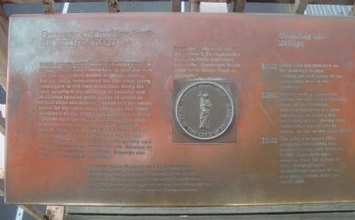
Panaroma of Brooklyn South of the Brooklyn Bridge
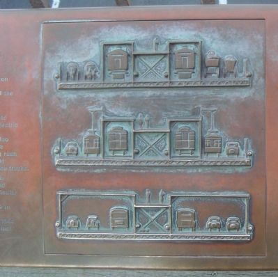
Crossing the Bridge
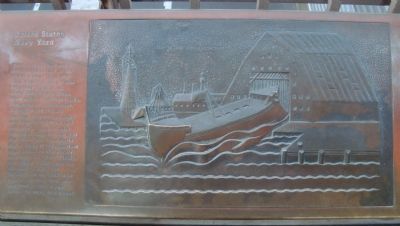
— United States Navy Yard —
Inscription.
People looking south towards Brooklyn from bridge in 1883 were treated to a spectacular view. 135 feet below them dozens of ferries, looking like toy boats, crisscrossed the East River, taking passengers to and from Manhattan. Along the busy waterfront the chimneys of factories and distilleries spouted great clouds of smoke as clipper ships and steamers sailed into the harbor, bound for the warehouses and docks that lined Brooklyn’s shore. Rising above the horizon in the distance were the steeples of Brooklyn’s many churches. Most were built in the nineteenth century when clever speculators offered land to congregations at no cost. Once a church was built, the lots around it were usually quickly sold off and developed for residential use. Because of its many ecclesiastic structures, Brooklyn was known as “the city of churches.”
Brooklyn’s city seal, which dates from 1834, depicts the Goddess Vesta and bears the motto “Eendraght Maakt Magt” – “In Union There is Strength.”
Crossing the Bridge
1883 – Cable cars are installed on the Brooklyn Bridge, running on both sides of the promenade next to the roadway.
1898 – Electric trolleys come into service on the bridge. Electric trains of the Brooklyn Elevated Company are also introduced, replacing the cable cars except during rush hours when both kinds of trains are run on the same tracks.
1952 – The bridge re-opens after extensive remodeling and accommodates only vehicular traffic. Cable cars were removed from the bridge in 1908. Elevated trains discontinued service in 1944, and trolleys made their last run in 1950.
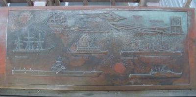
United States Navy Yard
The U.S. Navy Yard was established in 1801 on the site of a small local shipyard. Over the years it was expanded to 291 acres, comprising six dry docks, many miles of railroad tracks, lumber yards, warehouses, a hospital and officer’s housing. Ninety-three ships were built at the Navy Yard and several hundreds were refitted for battle in the Civil War, World War I and World War II. Some of the important ships launched at the Navy Yard were the “Ohio” (1820), the “Maine” (1890), and the “Missouri” (1944). The “Duluth,” the last ship to be built at the Navy Yard, was launched in 1965, a year before the Navy Yard closed.
Edward I. Koch, Mayor of the City of New York
Howard Golden, Borough President of Brooklyn
Andrew J. Stein, Borough President of Manhattan
The 1983 Brooklyn Bridge Centennial Commission The New York City Department of Transportation
Topics. This historical marker is listed in these topic lists: Bridges & Viaducts • Industry & Commerce
• Railroads & Streetcars • Waterways & Vessels. A significant historical year for this entry is 1883.
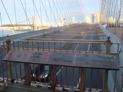
Location. 40° 42.437′ N, 73° 59.895′ W. Marker is in Manhattan, New York, in New York County. It is in Two Bridges. Marker can be reached from Brooklyn Bridge. This marker is located on the Brooklyn Bridge Promenade at the northwest tower observation platform, facing Brooklyn. Touch for map. Marker is in this post office area: New York NY 10038, United States of America. Touch for directions.
Other nearby markers. At least 8 other markers are within walking distance of this marker. How the Bridge was Built (a few steps from this marker); 1883 The City of Brooklyn (a few steps from this marker); The Brooklyn Bridge (within shouting distance of this marker); Lower East Side - Peck Slip (about 700 feet away, measured in a direct line); Lower East Side – 1767 (about 700 feet away); Peck Slip (about 700 feet away); The East River Bikeway and Esplanade (about 700 feet away); Jerry Driscoll Walk (approx. 0.2 miles away). Touch for a list and map of all markers in Manhattan.
More about this marker. This marker is presented in several photos as a readable version of it could not be shown in one photograph
Additional keywords. Panaroma
(sic) of Brooklyn South of the Brooklyn Bridge
Photographed By Barry Swackhamer, May 20, 2012
4. Panaroma (sic) of Brooklyn South of the Brooklyn Bridge Marker
Captions: Niagara 1858; Oriskany 1945; Ohio 1820; Cincinnati 1892; U.S. Navy Yard, Brooklyn, Empire Stores; Connecticut 1904; Duluth 1965.
(View of various ships launched at the United States Navy Yard.)
Credits. This page was last revised on January 31, 2023. It was originally submitted on January 28, 2013, by Barry Swackhamer of Brentwood, California. This page has been viewed 1,340 times since then and 64 times this year. Last updated on May 5, 2020, by Larry Gertner of New York, New York. Photos: 1, 2, 3, 4, 5. submitted on January 28, 2013, by Barry Swackhamer of Brentwood, California. • J. Makali Bruton was the editor who published this page.
