Betterton in Kent County, Maryland — The American Northeast (Mid-Atlantic)
Betterton
Sassafras River Water Trail
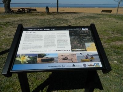
The Sassafras River Water Trail
From the headwaters near the Route 301 Bridge to the river's mouth between Grove Point and Howell Point, the Sassafras River Water Trail winds past forested shorelines, bucolic farms, and high sandy cliffs for 18 miles before reaching its confluence with the Chesapeake Bay. The Sassafras River Water Trail follows parts of the routes of both the Captain John Smith Chesapeake National Historic Trail and the Star-Spangled Banner National Historic Trail, managed by the National Park Service. It is also part of a system of water trails in the Chesapeake Bay Gateways and Watertrails Network.
Betterton Landing
Betterton Landing provides access to the open waters at the mouth of the Sassafras River. Betterton historically was a major tourist destination featuring a boardwalk, bandstand, and numerous hotels before the construction of the Bay Bridge in the 1950s encouraged tourists to bypass the Eastern Shore enroute to Ocean City.
Suggested Routes For Paddlers
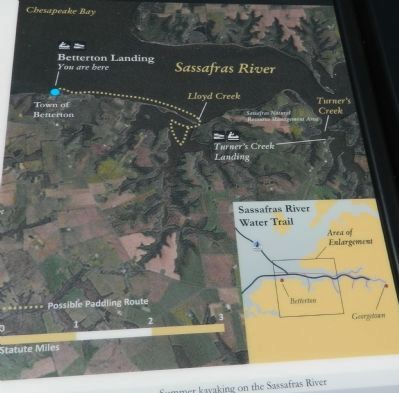
Lloyd Creek: Before setting out from this location, paddlers should be aware that these large open waters can get rough on windy days. Use caution and make sure to check the weather forecast before embarking on your journey! If the forecast is cooperative, try heading upriver while hugging this shoreline. Scenery here is characterized by high forested cliffs that contain numerous bald eagles, ospreys, and blue heron. In just over two miles, the mouth of Lloyd Creek is an excellent location to rest, swim, and fish. At this point, paddlers can return to the landing for a 5-mile round trip, explore the unspoiled wilderness of Lloyd Creek, or continue for another 3 miles upriver to Turner Creek Landing.
Paddling & Boating Safety
Safety should be your primary concern on the water - always remember to:
- Wear a USCG approved life jacket and follow all regulations.
- Leave your travel plans with a friend/loved one.
- Check the weather and tides before you leave.
Protecting the Sassafras River
When enjoying the Sassafras River please dispose of all trash in proper receptacles, respect private property and the privacy of others, and leave the natural environment as you found it. For more information about protecting the Sassafras River contact the Sassafras River Association or visit:
www.sassafrasriver.org
to learn more about the Sassafras River Water Trail visit www.srwt.org
Erected by Chesapeake Bay Gateways Network.
Topics and series. This historical marker is listed in these topic lists: Environment • Waterways & Vessels. In addition, it is included in the Captain John Smith Chesapeake National Historic Trail series list.
Location. 39° 22.24′ N, 76° 3.794′ W. Marker is in Betterton, Maryland, in Kent County. Marker is on Ericsson Avenue, on the right. Touch for map. Marker is in this post office area: Betterton MD 21610, United States of America. Touch for directions.
Other nearby markers. At least 8 other markers are within 5 miles of this marker, measured as the crow flies. Crew’s Landing (within shouting distance of this marker); Mary Roe Walkup Pavilion (within shouting distance of this marker); Hazelmore (approx. 3.1 miles away); Maryland’s First Women Voters (approx. 3.1 miles away); Welcome to the Kent Museum (approx. 4.3 miles away); Agricultural Demonstration Area / Historic Tree Grove (approx. 4.3 miles away); Captain John Smith on the Sassafras River (approx. 4.3 miles away); The Tockwogh and the Bay (approx. 4.3 miles away). Touch for a list and map of all markers in Betterton.
Credits. This page was last revised on March 2, 2021. It was originally submitted on April 18, 2013, by Bill Pfingsten of Bel Air, Maryland. This page has been viewed 550 times since then and 19 times this year. Last updated on March 2, 2021, by Carl Gordon Moore Jr. of North East, Maryland. Photos: 1, 2, 3. submitted on April 18, 2013, by Bill Pfingsten of Bel Air, Maryland. • J. Makali Bruton was the editor who published this page.


