Near Pinehurst in Jackson County, Oregon — The American West (Northwest)
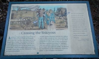
Crossing the Siskiyous
As Jesse Quinn Thronton and his wife trekked west in 1846, several of their oxen died in the Siskiyous forcing the Thorntons to hire other emigrants to carry some of their possessions. Thornton regretted traveling the Applegate Trail and publicly criticized the route in his book Oregon and California (1848). He blamed his misfortunes on the trailblazers whom he called "a class of outlaws and banditti."
Many of the cattle appeared to be too tired to feed, and were lying about upon the little hill-sides, ruminating in the sun. Some of the emigrants were busied in making arrangements for diminishing in some manner the weight of the load in their wagons. Others were silent, and appeared to be stupefied with their distresses. Children were crying for bread. Over all this scene, the sun shone as bright and clear as ever. - Jesse Quinn Thornton, Recollections of October 13, 1846
Topics and series. This historical marker is listed in these topic lists: Roads & Vehicles • Settlements & Settlers. In addition, it is included in the Applegate Trail series list. A significant historical date for this entry is October 13, 1846.
Location. 42° 6.953′ N, 122° 26.533′ W. Marker is near Pinehurst, Oregon, in Jackson County. Marker can be reached from Green Springs Highway (Oregon Route 66), on the right when traveling west. Touch for map. Marker is at or near this postal address: 12705-12727 Green Springs Highway, Ashland OR 97520, United States of America. Touch for directions.
Other nearby markers. At least 8 other markers are within 8 miles of this marker, measured as the crow flies. The Applegate Trail (a few steps from this marker); Tub Springs Sugar Pine (a few steps from this marker); Historic Applegate Trail (within shouting distance of this marker); Greensprings (approx. 1.2 miles away); Keene Creek Wagon Slide (approx. 2 miles away); Historic Applegate Trail 1846 - 1869 (approx. 2 miles away); Route of Historic Applegate Trail (approx. 6.6 miles away); Siskiyou Mountain Wagon Road (approx. 8.1 miles away). Touch for a list and map of all markers in Pinehurst.
Credits. This page was last revised on June 16, 2016. It was originally submitted on September 1, 2015, by Barry Swackhamer of Brentwood, California. This page has been viewed 377 times since then and 14 times this year. Last updated on September 9, 2015, by Steve Masler of Memphis, Tennessee. Photos: 1, 2. submitted on September 1, 2015, by Barry Swackhamer of Brentwood, California. • Andrew Ruppenstein was the editor who published this page.

