Photograph as originally submitted to
this page in the Historical Marker Database
www.HMdb.org.
Click on photo to resize in browser. Scroll down to see metadata.
Photographer: C. Watkins
Taken: Circa 1886
Caption:
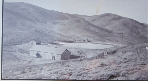
The Five Mile Reservoir | Additional Description:
{From the photo inset on the marker:} The Five Mile Reservoir was the intermediate reservoir to collect the water from the pipeline before it was piped to Virginia City. Located west of and above American Flat and on the East Side of McClellan Peak, the reservoir also served as a fish hatchery.
The reservoir functioned into the 1990s when the pipeline was extended direct to the county water treatment plant on The Divide at Ophir Grade Road in Virginia City.
Submitted: September 20, 2010, by Andrew Ruppenstein of Lamorinda, California.
Database Locator Identification Number: p128657
File Size: 0.131 Megabytes
To see the metadata that may be embedded in this photo, sign in and then return to this page.