Photograph as originally submitted to
this page in the Historical Marker Database
www.HMdb.org.
Click on photo to resize in browser. Scroll down to see metadata.
Photographer: Anna Inbody
Taken: October 2, 2011
Caption:
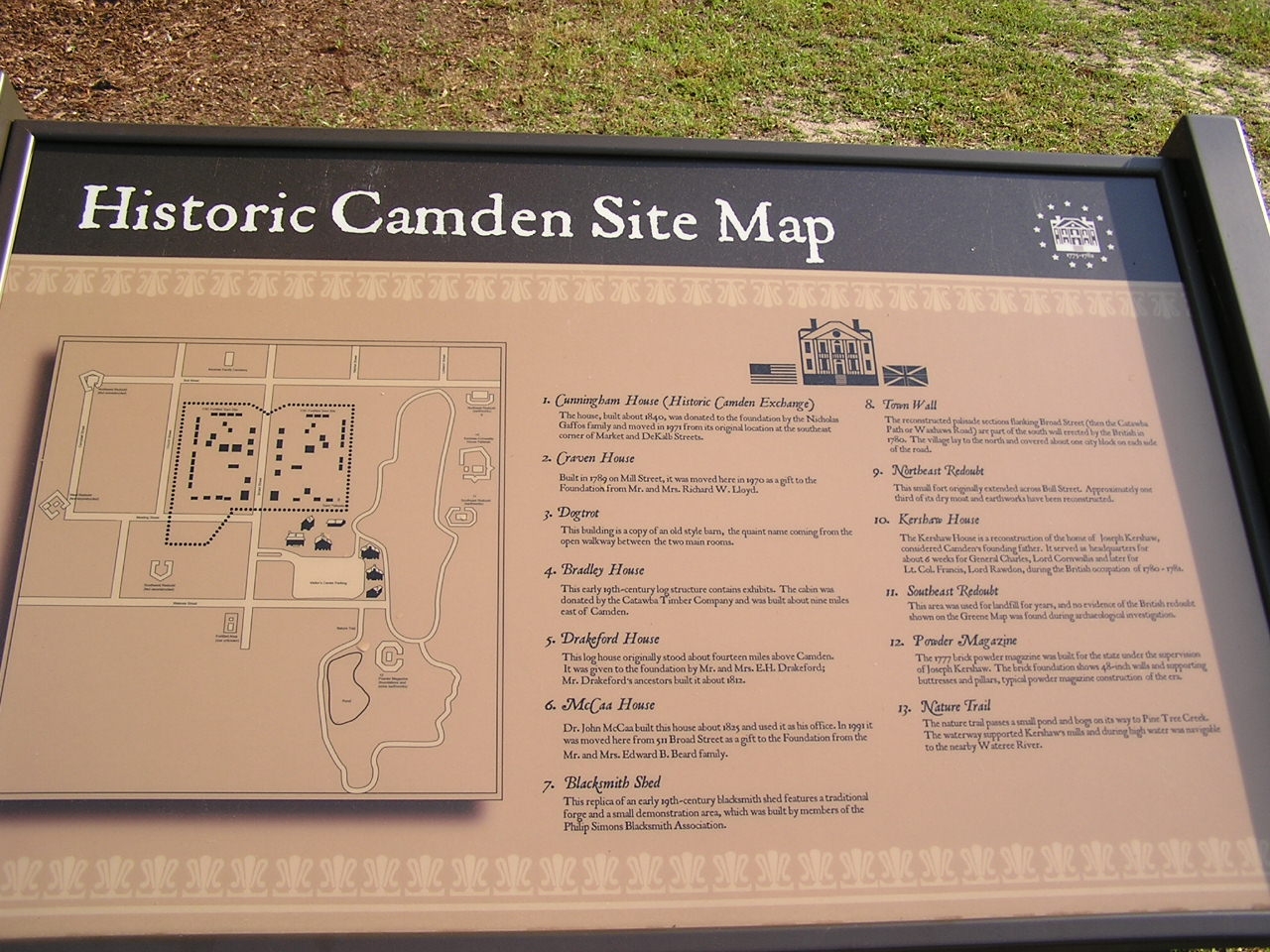
Historic Camden Revolutionary War Site Map | Additional Description: 1. Cunningham House (Historic Camden Exchange) The house, built about 1840, was donated to the foundation by the Nicholas Gaffon family and moved in 1971 from its original location at the southeast corner of Market and DeKalb Streets.
2. Craven House Built in 1789 on Mill Street, it was moved here in 1970 as a gift to the Foundation from Mr. and Mrs. Richard W. Lloyd.
3. Dogtrot This building is a copy of an old style barn, the quaint name coming from the open walkway between the two main rooms.
4. Bradley House This early 19th~century log structure contains exhibits. The cabin was donated by the Catawba Timber Company and was built about nine miles east of Camden.
5. Drakeford House This log house originally stood about fourteen miles above Camden. It was given to the foundation by Mr. and Mrs. E. H. Drakeford; Mr. Drakeford’s ancestors built it about 1812.
6. McCaa House Dr. John McCaa built this house about 1825 and used it as his office. In 1991 it was moved here from 511 Broad Street as a gift to the Foundation from the Mr. and Mrs. Edward B. Beard family.
7. Blacksmith Shed This replica of an early 19th~century blacksmith shed features a traditional forge and a small demonstration area, which was built by members of the Philip Simons Blacksmith Association.
8. Town Wall The reconstructed palisade sections flanking Broad Street (then the Catawba Path or Waxhaws Road) are part of the south wall erected by the British in 1780. The village lay to the north and covered about one city block on each side of the road.
9. Northeast Redoubt This small fort originally extended across Bull Street. Approximately one third of its dry moat and earthworks have been reconstructed.
10. Kershaw House The Kershaw House is a reconstruction of the home of Joseph Kershaw, considered Camden’s founding father. It served as headquarters for about 6 weeks for General Charles, Lord Cornwallis and later for Lt. Col. Francis, Lord Rawdon, during the British occupation of 1780 - 1781.
11. Southeast Redoubt This area was used for landfill for years, and no evidence of the British redoubt shown on the Greene Map was found during archaeological investigation.
12. Powder Magazine The 1777 brick powder magazine was built for the state under the supervision of Joseph Kershaw. The brick foundation shows 48~inch walls and supporting buttresses and pillars, typical powder magazine construction of the era.
13. Nature Trail The nature trail passes a small pond and bogs on its way to Pine Tree Creek. The waterway supported Kershaw’s mills and during high water was navigable to the nearby Wateree River.
Submitted: October 28, 2011, by Anna Inbody of Columbia, South Carolina.
Database Locator Identification Number: p178697
File Size: 0.266 Megabytes
To see the metadata that may be embedded in this photo, sign in and then return to this page.