Photograph as originally submitted to
this page in the Historical Marker Database
www.HMdb.org.
Click on photo to resize in browser. Scroll down to see metadata.
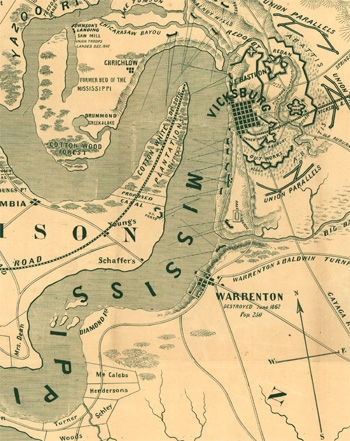
Photographer: Kurz and Allison
Taken: 1863
Caption:
Vicksburg Area Map During Civil War | Additional Description: Vicksburg and the Mississippi River circa 1863 (Library of Congress)
Submitted: March 9, 2014, by Cleo Robertson of Fort Lauderdale, Florida.
Database Locator Identification Number: p267803
File Size: 0.104 Megabytes
To see the metadata that may be embedded in this photo, sign in and then return to this page.