Photograph as originally submitted to
this page in the Historical Marker Database
www.HMdb.org.
Click on photo to resize in browser. Scroll down to see metadata.
Photographer: Rev. Ronald Irick
Taken: August 28, 2014
Caption:
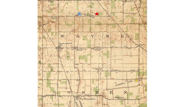
Map of the Auglaize River Marker and other sites | Additional Description: 1915 USGS Alger sw 15 minute series, marked and colored by Dr. Ronald Irick
Red star is this marker
Blue star is furthest reach of Willow Branch,
a tributary of Muchinippi Creek,
an upper fork of the Great Miami River
Yellow star is considered the “legal” headwaters of the Scioto,
Although Wallace Fork comes within a few hundred feet of the Auglaize marker
If you notice the benchmarks on this topo, the land is absolutely FLAT
It is very difficult to differentiate between the Scioto Marsh and the Auglaize Wet Prairie.
Submitted: August 28, 2014, by Rev. Ronald Irick of West Liberty, Ohio.
Database Locator Identification Number: p284006
File Size: 0.369 Megabytes
To see the metadata that may be embedded in this photo, sign in and then return to this page.