Photograph as originally submitted to
this page in the Historical Marker Database
www.HMdb.org.
Click on photo to resize in browser. Scroll down to see metadata.
Photographer: State of Louisiana
Caption:
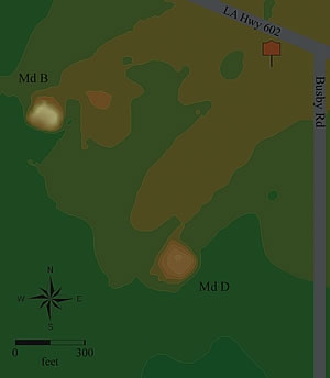
Map showing mound locations. | Additional Description: Originally, at least four mounds formed a plaza, and two of them had ramps that led to their summits. The largest mound was almost 30 feet tall. A 3-foot-high causeway 75 feet wide extended west about 2,700 feet from one of the mounds; that mound was later used for fill to build Interstate 20.
Submitted: September 26, 2015, by Mark Hilton of Montgomery, Alabama.
Database Locator Identification Number: p330862
File Size: 0.009 Megabytes
To see the metadata that may be embedded in this photo, sign in and then return to this page.