Photograph as originally submitted to
this page in the Historical Marker Database
www.HMdb.org.
Click on photo to resize in browser. Scroll down to see metadata.
Photographer: Barry Swackhamer
Taken: June 21, 2017
Caption:
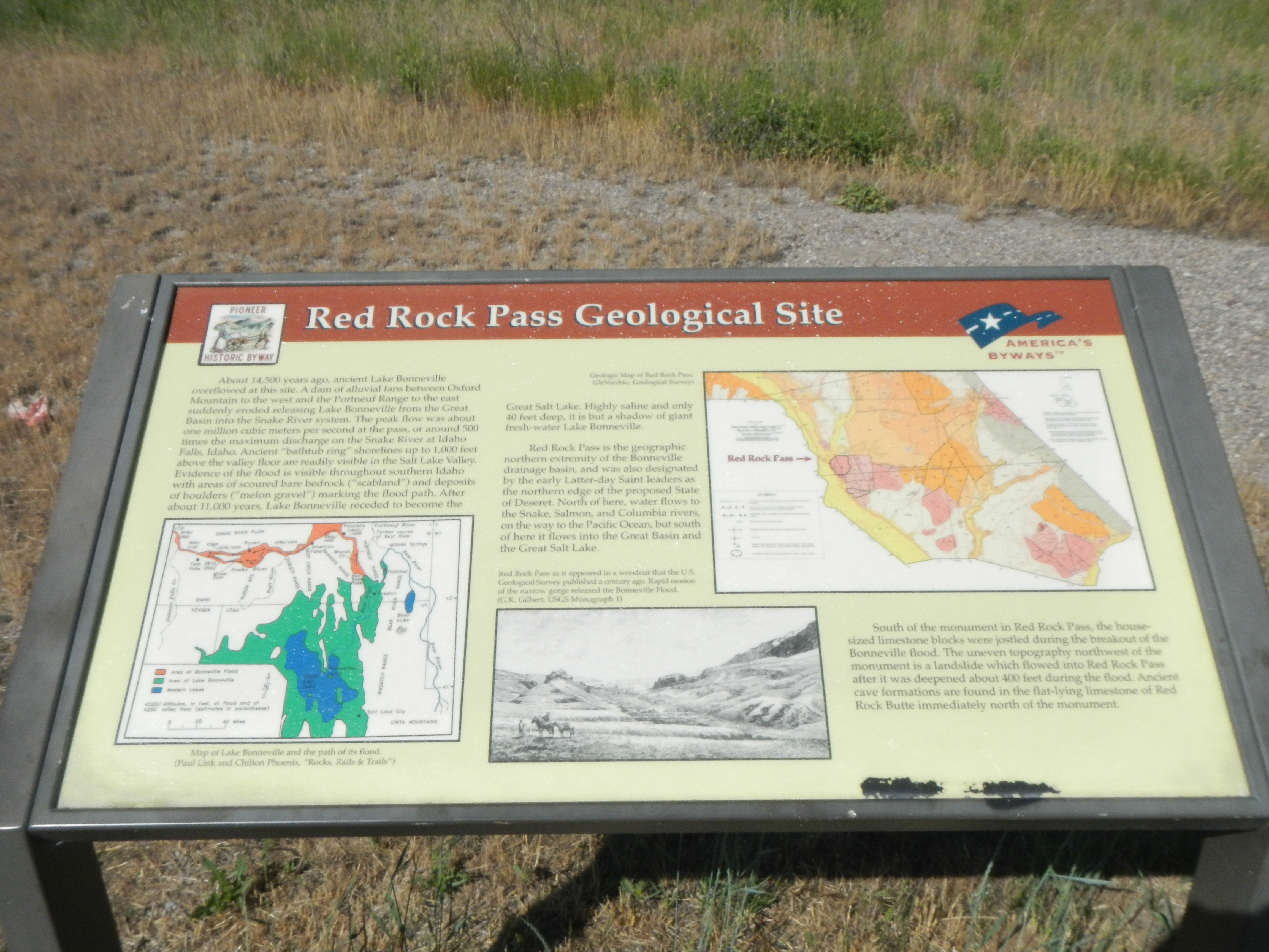
Red Rock Pass Geological Site plaque | Additional Description: About 14,500 years ago, ancient Lake Bonneville overflowed at this site. A dam of alluvial fans between Oxford Mountain to the west and the Portneuf Range to the east suddenly eroded releasing Lake Bonneville from the Great Basin into the Snake River system. The peak flow was about one million cubic meters per second at the pass, or around 500 times the maximum discharge on the Snake River at Idaho Falls, Idaho. Ancient "bathtub ring" shorelines up to 1,000 feet above the valley floor are readily visible in the Salt Lake Valley. Evidence of the flood is visible throughout southern Idaho with areas of scoured bare bedrock ("scabland") and deposits of boulders ("melon gravel") marking the flood path. After about 11,000 years, Lake Bonneville receded to become the Great Salt Lake. Highly saline and only 40 feet deep, it is but a shadow of giant fresh-water Lake Bonneville.
Red Rock Pass is the geographic northern extremity of the Bonneville drainage basin, and was also designated by the early Latter-day Saints leaders as the northern edge of the proposed State of Deseret. North of here, water flows to the Snake, Salmon, and Columbia rivers, on the way to the Pacific Ocean, but south of here it flows into the Great Basin and the Great Salt Lake.
South of the monument in Red Rock Pass, the house-sized limestone blocks were jostled during the breakout of the Bonneville flood. The uneven topography northwest of the monument is a landslide with flowed into Red Rock Pass after it was deepened about 400 feet during the flood. Ancient cave formations are found in the flat-lying limestone of Red Rock Butte immediately north of the monument.
Captions: (bottom left) Map of Lake Bonneville and the path of its flood.; (bottom center) Red Roak Pass as it appeared in a woodcut that the U.S. Geological Survey published a century ago. Rapid erosion of the narrow gorge released the Bonneville Flood.; (upper right)
Geological Map of the Red Rock Pass area.Submitted: July 19, 2017, by Barry Swackhamer of Brentwood, California.
Database Locator Identification Number: p390602
File Size: 3.580 Megabytes
To see the metadata that may be embedded in this photo, sign in and then return to this page.