Photograph as originally submitted to
this page in the Historical Marker Database
www.HMdb.org.
Click on photo to resize in browser. Scroll down to see metadata.
Photographer: Brandon D Cross
Taken: August 23, 2020
Caption:
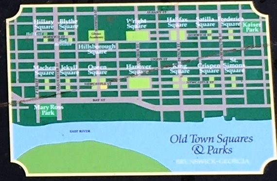
Photo Insert (Bottom Right): 1771 Town Plat “the Oglethorpe Plan” | Additional Description: In 1771, the city of Brunswick, Georgia was laid out according to “the Oglethorpe plan,” named after the colony’s founder, General James Edward Oglethorpe . The design featured a grid of 14 large and 14 small squares. The intention of the plan was to create permanent, park-like common areas throughout the city. The squares still bear their original names, which reveal Brunswick’s strong historic ties to England.
Submitted: September 2, 2020, by Brandon D Cross of Flagler Beach, Florida.
Database Locator Identification Number: p537018
File Size: 0.100 Megabytes
To see the metadata that may be embedded in this photo, sign in and then return to this page.