Photograph as originally submitted to
this page in the Historical Marker Database
www.HMdb.org.
Click on photo to resize in browser. Scroll down to see metadata.
Photographer: Craig Swain
Caption:
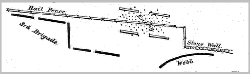
Hall's Map of the High Water Mark Area | Additional Description: Col. Hall provided this map in his official report. North is to the right, with the stone wall around the angle and rail fence in front of Third Brigade noted.
Submitted: February 22, 2009, by Craig Swain of Leesburg, Virginia.
Database Locator Identification Number: p53842
File Size: 0.006 Megabytes
To see the metadata that may be embedded in this photo, sign in and then return to this page.