Photograph as originally submitted to
this page in the Historical Marker Database
www.HMdb.org.
Click on photo to resize in browser. Scroll down to see metadata.
Photographer: William Fischer, Jr.
Taken: June 6, 2009
Caption:
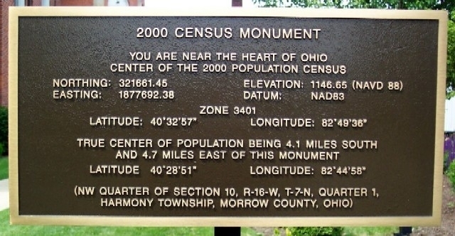
Nearby 2000 Census Monument | Additional Description: You are near the heart of Ohio
Center of the 2000 population census
Northing: 321661.45 Elevation 1146.65 (NAVD 88)
Easting: 1877692.38 Datum: NAD83
Zone 3401
Latitude: 40°32’57” Longitude: 82°49’36”
True center of population being 4.1 miles south
and 4.7 miles east of this monument
Latitude: 40°28’51” Longitude: 82°44’58”
(NW Quarter of Section 10, R-16-W, T-7-N, Quarter 1,
Harmony Township, Morrow County, Ohio)
Submitted: June 11, 2009, by William Fischer, Jr. of Scranton, Pennsylvania.
Database Locator Identification Number: p68798
File Size: 0.084 Megabytes
To see the metadata that may be embedded in this photo, sign in and then return to this page.