On Windward Coastal Highway at Sineku School Road, on the right when traveling north on Windward Coastal Highway.
Carib war, September 19th 1930. Two Caribs died. Dudley John and Royer Frederick, two injured Tilson Bruney and Ferdinand Sanford. Sauteus of Grenada Kioumoue titanyem oubecouyum Santiquet ala eyeti Our father who art in heaven Hallowed be thy . . . — — Map (db m135260) HM
On Goodwill Road just north of Winston Lane, on the left when traveling north.
Pottersville By the Pottersville Savannah View of Woodbridge Bay in 1960 prior to the construction of the Deep Water Harbour. Walking distances to various historic sites and landmarks Map, key and emergency information . . . — — Map (db m135343) HM
On Victoria Street at Turkey Lane, on the right when traveling west on Victoria Street.
Anglican Church 1820 A permanent Anglican church was constructed on current site. British government funded the construction of the church for £6,500. It was built in the style of the Regency period which consists of a square, solid stone . . . — — Map (db m135310) HM
On Independence Street just east of Bath Street, on the right when traveling north.
David the Goliath The African Baobab Tree (Adansonia digitata) was blown down on the bus during Hurricane David on August 29th 1979. Fortunately the bus was empty at the time. The main stem is now more than 21 ft (6.4 m) in circumference and . . . — — Map (db m135318) HM
On Virgin Lane at Cross Street, on the right when traveling north on Virgin Lane.
Methodist Church
1787 • First Methodist missionary, Dr. Thomas Coke arrived.
It was originally a dwelling house.
1800 • The lot where the church is now was initially leased to Catholics who later converted to Wesleyan . . . — — Map (db m135311) HM
On Morne Bruce Road, on the left when traveling north.
Morne Bruce Garrison The Defence of Roseau Dominica was ceded to Britain by the Treaty of Paris in 1763. To keep the island under her rule, Britain had to defend it from the French. Some small forts were started in 1765. Military engineers . . . — — Map (db m135344) HM
Near Unnamed road just west of Morne Bruce Road, on the right when traveling north.
Morne Bruce Garrison North Point Battery Cannon and Signaling Station To get messages up and down the coast, Captain James Bruce organised a line of signal stations. The signals were a combination of gun salutes and flag signals. Each . . . — — Map (db m135345) HM
On Turkey Lane close to Victoria Street. Reported missing.
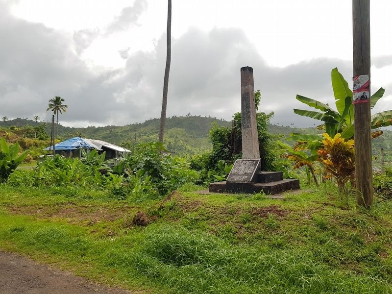
This monument is a symbol of freedom and emancipation. It is a tribute to all the enslaved Africans who suffered and were executed in the history of Dominica. It honours the Maroons who risked their lives to fight for the emancipation of all. It . . . — — Map (db m94220) HM
On Elliot Avenue at St. John's Avenue, on the left when traveling north on Elliot Avenue.
Pottersville Was once known as Ballahoo Town and then Lod bor – creole for “the other side”. Was mainly occupied by fishermen, domestics and port workers who worked in Roseau. Pottersville was named after . . . — — Map (db m135316) HM
On Dame Mary Eugenia Charles Boulevard just west of Church Street, on the left when traveling west.
Roseau Cruise Ship Berth Left: The origins of our main streets are based on footpaths leading to and from the market and landing place at the old harbour. Where you now stand is the site of the old harbour. Below: View of Roseau . . . — — Map (db m135309) HM
On Dame Mary Eugenia Charles Boulevard at Drury Lane, on the left when traveling west on Dame Mary Eugenia Charles Boulevard.
Roseau Bayfront Ferry Terminal Roseau Bayfront 1900, at the time it was known as Bay Street. For many years the town was fronted by a wide beach but after a series of hurricanes, sea defence walls were built along the waterfront. . . . — — Map (db m135342) HM
On Virgin Lane just north of Cross Street, on the right when traveling north.
Roseau Cathedral 1730 First started as a 16 x 40 ft solid timber church. This was fashioned after the Kalinago Kabays, consisting of strong posts and woven palm leaves. It was constructed by French lumbermen and peasant farmers. The original . . . — — Map (db m135314) HM
On Princess Lane at Charles Avenue, on the left when traveling north on Princess Lane.
Simon Bolivar Born in Caracas 24th July 1783 Died in Santa Marta 17th December 1830 Liberator of Venezuela, Colombia, Ecuador and Peru Founder of Bolivia — — Map (db m117234) HM WM
On Edward Oliver Leblanc Highway just north of Charles Avenue, on the left when traveling north.
Woodbridge Bay 1777 Woodbridge Bay is named after William Woodbridge, who from 1777, was the owner of Goodwill Estate. 1925 Prior to the construction of the Deep Water Harbour, it was a popular bathing spot lined with private beach huts and a . . . — — Map (db m135259) HM
Dominica In memory of those from Dominica who gave their lives in the Great War 1914-1918 Capt. A. E. Anderson · Capt. C. M. Blandy · Major Geo. W. Carew · Capt. G. Carter · Capt. C. H. Hill · Lieut. H. T. S. Johns · Lieut. F. Johnson · Capt. R. . . . — — Map (db m93900) WM
3000 BC - The first Amerindian people settle in the bay. Les premiers Amérindiens s'installent dans la baie. 1493 - One ship of Columbus fleet on his 2nd Voyage enters the bay and sees dwellings and people. Un navire de la flotte de Christophe . . . — — Map (db m94478) HM
This is the second national park established in Dominica and comprises both land and sea - rich in natural resources and historical features, the area supports a wide range of important activities, including diving, snorkeling, yachting, cruise . . . — — Map (db m94440) HM
Fort Shirley was positioned between the two hills with a direct line of site (sic, sight) to all parts of the garrison and guarding directly over Prince Rupert's Bay and the dock. The land side of the fort was protected by batteries in other . . . — — Map (db m94476) HM
The Guard House, manned at all times, was the nerve centre of the entire garrison. All signals and comings and goings were monitored here. Gun slits faced onto the entrance passage in the event of an invasion. The room behind was the prison or . . . — — Map (db m94499) HM
The officers lived in separate quarters. Some had their families with them, in the married quarters on the slope or down in Roseau as the garrison, close to the swamp, was considered unhealthy. The Commandant live in an elegant house up against the . . . — — Map (db m94500) HM
The Cabrits headland was recognized by the British in the 18th century as a strategic site for a garrison to protect ships anchored in Price Rupert's Bay to collect fresh water and provisions, and for a defence stronghold between French colonies of . . . — — Map (db m94474) HM
During the 18th and early 19th centuries, most of the forest on the Cabrits was cut down to clear land for the garrison. The forest you now see around you dates from after 1854, when the garrison was abandoned. There are also some experimental . . . — — Map (db m94475) HM
The garrison at the Cabrits never saw any action, although the Battle of the Saints, fought between the French and British fleets on 12 April 1782, occurred within sight of the ramparts, and Fort Shirley was the scene of the revolt of the 8th West . . . — — Map (db m94501) HM
Fort Shirley was served by three cisterns that collected water from the roofs and the water catchment platform. If there was threat of an attack, water from the nearby rivers was brought into the fort by oxen cart. Food was purchased from . . . — — Map (db m94502) HM
The Salisbury Declaration of Independence This Monument is in Commemoration of The Declaration To Seek Independence From Great Britain By Honourable Patrick Roland John On Sunday August 29 1976 Unveiled by His Excellency The President Mr. . . . — — Map (db m117231) HM
On West Coast Road, on the left when traveling south.
1923 · 2004
In Honour of: Edward Oliver Le Blanc Statesman Member of the Federal Parliament of the West Indies (1958-1960) Chief Minister and Minister of Finance (1961-1967) Premier of Dominica 1967-1974 The construction of the West Coast Road . . . — — Map (db m94387) HM