Near Theorias north of Dionysiou Areopagitou Street, on the right when traveling north.
English Text:
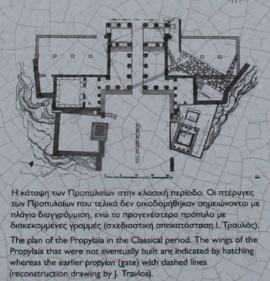
A. The Propylaia
The Propylaia, the monumental entrance of the sanctuary of the Acropolis, was built at the west edge of the hill in the frame of the building programme of Perikles. The building's . . . — — Map (db m85103) HM
Near Theorias north of Dionysiou Areopagitou Street, on the right when traveling north.
English Text:
A. The sanctuary of Artemis Brauronia
After passing through the Propylaia, the sanctuary of Artemis Brauronia, the so-called Brauronion, lies to the right of the processional way of the Acropolis. It was . . . — — Map (db m85203) HM
On Theorias north of Dionysiou Areopagitou Street, on the left when traveling north.
[Left columns - text in Greek]
[Right columns - text in English]
The Areopagus, a rocky outcrop approximately 115 m. high is situated between three other hills, the Acropolis, the Pnyx, and the Kolonos Agoraios. Its name . . . — — Map (db m47716) HM
A Doric peripteral temple, with pronaos (fore-temple), cella (inner shrine), and opisthonaos (rear wing), the best preserved of its type in the Greek world. The facade of the pronaos and opisthonaos, to the east and west, . . . — — Map (db m126052) HM
Near Anafiotika north of Dionysiou Areopagitou Street, on the right when traveling north.
The large Archaic temple to the south of the Erechtheion, which today preserves only its foundations, was called the "Old Temple" according to epigraphic evidence. Dedicated to Athena Polias, the patron deity of the city, it housed the . . . — — Map (db m85232) HM
On Theorias Street, 0.3 kilometers north of Dionysiou Areopagitou Street, on the right when traveling north.
[Marker text printed in both Greek and English scripts:]
The Acropolis and its monuments, universal symbols of the classical spirit and culture, form the greatest architectural and artistic whole that Greek Antiquity has bequeathed to . . . — — Map (db m43648) HM
Near Dionysiou Areopagitou north of Dionysiou Areopagitou Street, on the right when traveling north.
English Text:
The elegant building of the Ionic order is called, according to later literary sources, Erechtheion from the name of Erechtheus, the mythical king of Athens. The construction started before the outbreak of the . . . — — Map (db m85173) HM
Near Dionysiou Areopagitou north of Dionysiou Areopagitou Street, on the right when traveling north.
English Text
The Parthenon was a temple dedicated to Athena Parthenos (Virgin). It is built in the Doric order and made of white Pentelic marble with a width of 30.86 meters, a length of 69.51 meters and a height of 15 meters. It has an . . . — — Map (db m85214) HM
Near Theorias north of Dionysiou Areopagitou Street, on the right when traveling north.
English Text:
The colossal bronze statue of Athena, known as Athena Promachos, dominated in the area between the Propylaia and the Erechtheion, to the left of the visitor walking along the processional way of the Acropolis. It was made . . . — — Map (db m85182) HM
This monumental water clock was constructed at the end of the 4th cent. B.C. in a prominent location at the southwest corner of there Agora square, on the street leading from the Agora up to the Pnyx. Water was drawn by a stone drain. The device was . . . — — Map (db m126058) HM
Near Dionysiou Areopagitou close to Mitseon, on the right when traveling west.
Η αρχαιολογική αναδκαφή
(Text in Greek above. To read it enlarge the marker image.) English:
The remains of a neighborhood . . . — — Map (db m126107) HM
ΣΤΟΑ ΤΟΥ ΑΤΤΑΛΟΥ (156-138 π.X.)
(Text in Greek on the left side) English:
The Stoa, on the east side of the Ancient Agora, was the gift of Attalos . . . — — Map (db m126105) HM
On Panos Street close to Tholou Street, on the left when traveling north.
The house at 22 Panos Street is a two-storey house, with a simple, traditional architecture, built at the beginning of the 19th century. The building has a ground (entrance) floor and an upper storey. It was restored by the Ministry of Culture, in . . . — — Map (db m126065) HM
Near Dedalou south of Glafkou, on the left when traveling south.
English Text:
Three large pits, known as "Kouloures" (rings) (Figure 1), with stone-lined walls were built in the West Court during the Old Palace period (1900-1700 B.C.). The excavation workmen gave them their name and Arthur Evans kept . . . — — Map (db m85436) HM
Near Dedalou south of Glafkou, on the left when traveling south.
English Text:
The room before you resembles a cistern. Its floor is lower than the surrounding area and is reached by steps. The "Lustral Basin" was surrounded by columns and was lined with slabs of gypsum giving it a luxurious . . . — — Map (db m85439) HM
Near Dedalou south of Glafkou, on the left when traveling south.
English Text:
The great staircase and the upper floor to which it leads are largely Evan's creations. Evans thought that it had a function rather like the first floor of Italian Palazzi of the Renaissance, which was called the "Piano . . . — — Map (db m85453) HM
Near Eparchiaki Odos Knossou - Charaka south of Glafkou, on the left when traveling south.
English Text:
The room before you was made into a shrine at the end of the Postpalatial period (1375-1200 B.C.). It is known as the "Shrine of the Double Axes" (Figure 1). On a bench at the back, different ritual objects were found . . . — — Map (db m85476) HM
Near Dedalou south of Glafkou, on the left when traveling south.
English Text:
The area before you was called the "Theatre" by Evans because its shape reminded him of later theatres (Figure 1). It is a platform and rows of steps that form an angle. At the bottom of the steps is the end of a narrow . . . — — Map (db m85403) HM
Near Dedalou south of Glafkou, on the left when traveling south.
English Text:
You are in the antechamber of a complex of rooms that Evans named the "Throne Room". Its name comes from the stone seat found in the room behind the antechamber (Figure 1).
Stone benches are preserved in the . . . — — Map (db m85440) HM
Near Dedalou south of Glafkou, on the left when traveling south.
The complex of the "West Magazine", an impressive row of eighteen long, narrow spaces (numbered in Latin numerals from one to eighteen), forms the main storage area of the Palace of Knossos.
The construction-restoration work, undertaken . . . — — Map (db m85556) HM
Near Labreos south of Glafkou, on the left when traveling south.
English Text:
An open air passage linked the Central Court with the North Entrance. It was paved and sharply inclined towards the north.
The passage is narrow. Right and left were two raised colonnades known as "Bastions" (Figure . . . — — Map (db m85549) HM
Near Eparchiaki Odos Knossou - Charaka south of Glafkou, on the left when traveling south.
English Text:
The south part and south facade of the Palace is very eroded. Today one can only see foundations on tiered levels. At the bottom, a tower-like projection is all that remains of the south entrance to the Palace. An ascending . . . — — Map (db m85469) HM
Near Eparchiaki Odos Knossou - Charaka south of Glafkou, on the left when traveling south.
English Text:
Archaeological information concerning political organization during the Minoan period is very limited. Nevertheless, the mythological tradition concerning King Minos and Evan's notions concerning the institution of kingship . . . — — Map (db m85496) HM
Near Labreos south of Glafkou, on the left when traveling south.
English Text:
The great pithoi (storage jars) you see before you, were found in a place named by Evans, the "Magazines of the Giant Pithoi" (Figure 1). These magazines are one of the older parts of the Palace. The pithoi are set apart by . . . — — Map (db m85506) HM
Near Dedalou south of Glafkou, on the left when traveling south.
English Text:
The "Palace and Archaeological Site of Knossos" project, intended both to deal with the various problems faced by the monument and to promote it, was included in the 3rd Community Support Fund (CSF) in 2000, to be . . . — — Map (db m85562) HM
Near Dedalou south of Glafkou, on the left when traveling south.
English Text:
In front of you can be seen part of the water system that channelled drinking water from a source in the vicinity of the palace. This took the form of a series of clay pipes with one end narrower than the other so that they . . . — — Map (db m85520) HM
Near Dedalou south of Glafkou, on the left when traveling south.
English Text:
Looking down, you can see the start of the corridor that joins eighteen long and narrow storerooms, covering an area of 1300 square meters (Figure 1).
In the floor of both the storerooms and corridor, there are . . . — — Map (db m85449) HM
Near Dedalou south of Glafkou, on the left when traveling south.
English Text:
The stairs on the right lead from the Central Court to the upper floor of the West Wing. This is largely reconstructed by Evans.
The area left of the stairs has been identified as a shrine, called by Evans the . . . — — Map (db m85442) HM
Near Agiou Christoforou west of Filippou, on the right when traveling west.
English Text:
The ancient theater of Philippi is a very important monument, located on the southeastern hillside of the acropolis leaning against the eastern city wall. Its initial phase is dated in the reign of the King of Macedonia . . . — — Map (db m84753) HM
Near Agiou Christoforou west of Filippou, on the right when traveling west.
North of the octagonal church, and with the Hellenistic tomb-heroon continuing to function as nucleus, the spaces of prothesis, diakonikon, phiale and baptistery were developed. The later consisted of apodyterium, catechumena, baptistery and . . . — — Map (db m84813) HM
Near Agiou Christoforou west of Filippou, on the right when traveling west.
English Text:
It was built as a great three-aisled, timber-roofed basilica with a transept on the east side. Its dimensions are 130x50 m. There is a monumental semi-circular propylon with marble stairs that leads from the Forum to the . . . — — Map (db m84772) HM
Near Agiou Christoforou just west of Filippou, on the right when traveling west.
English Text:
Philippi was a flourishing city in eastern Macedonia during the Hellenistic, Roman, and Early Christian periods, with continuous habitation from the mid-4th century BC to the 14th century AD. The city's 3500-meter long . . . — — Map (db m84801) HM
Near Agiou Christoforou just west of Filippou, on the right when traveling west.
English text:
The ancient city of Philippi was built on the fringes of the marshes that occupied the south-east part of the plain of Drama. The first settlers were colonists from Thasos who were aware of the rich sources of precious . . . — — Map (db m84747) HM
Near Agiou Christoforou west of Filippou, on the right when traveling west.
English Text
In the first insula east of the Roman Forum at Philippi. between the eastward extensions of Egnatia and Emporiki streets, is the metropolitan church of Philippi, the famous Octagon, which is dedicated to the . . . — — Map (db m84804) HM
On Ethniki Odos Dramas Kavalas (Macedonia and Thrace Route 12) east of Egnatia Odos (National Route E90), on the right when traveling east.
Marker's English Text:
Kavala
The history of the town begins in the 7th century BC, in the reign of Philip II, father of Alexander the Great, flourished here the seaport of Neapolis (Kavala) which served the city of . . . — — Map (db m84727) HM
On Erithrou Stavrou south of Nyremvergis (Macedonia and Thrace Route 2), on the right when traveling east.
Marker's English Text:
Historical Outline
The Panagia peninsula has been inhabited since the Early Iron Age (1050-700 BC). In the second half of the 7th century BC, Parian settlers from Thasos founded a new . . . — — Map (db m84729) HM
On Ethnikis Aminis just east of Nikiforou Foka, on the right when traveling east.
The exhibition presents the history of Thessaloniki from its founding to the modern era. The founding of the city, its urban plan development, its people, its economy and its culture are the main topics that the exhibition addresses. In other . . . — — Map (db m84724) HM
On Ethnikis Aminis east of Nikiforou Foka, on the right when traveling east.
The White Tower, which came to be the symbol of Thessaloniki by coincidence, was built in the late 15th century on the site of an older Byzantine tower, where the eastern wall and the sea wall met.
The White Tower is 33.9 meters high and . . . — — Map (db m84701) HM
Near Ethniki Odos Kerkiras Achiliou (Route EO 25), on the left when traveling east.
The texts on this marker are written in Greek (left), English (center-left), German (center-right) and French (right). Only the English text has been transcribed. To read the Greek, German and French texts, enlarge the marker image by clicking on . . . — — Map (db m126429) HM
Near Ethniki Odos Kerkiras Achiliou (Route EO 25), on the left when traveling east.
French:
Les troupes Alliées ont utilisé l'ile de Corfou afin d'y recueillir et abriter
l'armée Serbe apes sa retraite a travers l'albanie
le 17 Février 1916, le géneral de brigade de Mondesir
Commandant les troupes francaises et le . . . — — Map (db m126432) HM WM
Near Ethniki Odos Kerkiras Achiliou (Route EO 25), on the left when traveling east.
The texts on this marker are written in Greek (top) and English (bottom). Only the English text has been transcribed. To read the Greek, text, enlarge the marker image by clicking on it.
English:
The entrance gate to Achillion . . . — — Map (db m126436) HM
Near Agoniston Politechniou at 39.6242, 19.9288, on the right when traveling north.
The texts on this marker are written in Greek (top) and English (bottom). Only the English text has been transcribed. To read the Greek, text, enlarge the marker image by clicking on it.
ΣTPATΩNAΣ . . . — — Map (db m126480) HM
Near Agoniston Politechniou at Victoros Dousmani, on the right when traveling north.
The church of Saint George was built during the period when the island was a British Protectorate (1815-1864). Construction began in 1840 in accordance with the design of the English military architect Anthony Emmett, so that the church could serve . . . — — Map (db m126479) HM
On Agoniston Politechniou close to Victoros Dousmani, on the right when traveling west.
The texts on this marker are written in Greek (top) and English (bottom). Only the English text has been transcribed. To read the Greek, text, enlarge the marker image by clicking on it.
English:
The German general Matthias von der . . . — — Map (db m126440) HM
Near Agoniston Politechniou at Victoros Dousmani, on the left when traveling north.
The texts on this marker are written in Greek (top) and English (bottom). Only the English text has been transcribed. To read the Greek, text, enlarge the marker image by clicking on it.
ΛATINIKO ΠAPEKΛKHΣI THΣ . . . — — Map (db m126477) HM
On Agoniston Politechniou close to Victoros Dousmani, on the right when traveling north.
The texts on this marker are written in Greek (top right) and English (bottom right). Only the English text has been transcribed. To read the Greek, text, enlarge the marker image by clicking on it.
English:
The Old Fortress's . . . — — Map (db m126476) HM
Near Agoniston Politechniou at 39.623286, 19.929149, on the left when traveling north.
The texts on this marker are written in Greek (bottom left) and English (bottom right). Only the English text has been transcribed. To read the Greek, text, enlarge the marker image by clicking on it.
English:
The Old Fortress's . . . — — Map (db m126514) HM
Near Agoniston Politechniou at Victoros Dousmani, on the right when traveling north.
This building is not preserved (it was damaged by the bombs placed by Germans in 1943 and was subsequently demolished). It was the most important Venetian monument of the Old Fort. It was destroyed by an earthquake in 1743 and was rebuilt in 1753 . . . — — Map (db m126516) HM
Near Enotiki Archeas Korinthou north of EO Korinthou Argous (Local Route 7), on the left when traveling north.
English Text:
The buildings in the west end of the Roman Forum date from the 1st and 2nd century AD. In contrast to most temples of both Greek and Roman periods in Greece, the temples each stood on a high podium constructed of rubble and . . . — — Map (db m84867) HM
Near Enotiki Archeas Korinthou west of EO Korinthou Argous (Local Route 7), on the left when traveling north.
English Text:
The fountain of Glauke, a large cubic mass of limestone, was formed when the surrounding bedrock was quarried away. Originally, the fountain was contained within a long limestone ridge running west from Temple Hill. . . . — — Map (db m84823) HM
Near Enotiki Archeas Korinthou north of EO Korinthou Argous (Local Route 7), on the left when traveling north.
English Text:
Propylaie on the Lechaion Road
The Propylaia, the main entrance to the Forum, consisted of three archways; one main and two smaller ones. At the time of Pausanias the gilded bronze chariots of Helios and . . . — — Map (db m84967) HM
On Enotiki Archeas Korinthou north of EO Korinthou Argous (Local Route 7) when traveling north.
English Text:
Peirene is one of the most important topoi in the urban landscape of both Greek and Roman Corinth. Human activity is attested in the area from the Neolithic period, and the first efforts in water management date to the . . . — — Map (db m84991) HM
Near Enotiki Archeas Korinthou north of EO Korinthou Argous (Local Route 7), on the left when traveling north.
The route of the ancient traveler Pausanias through the Corinthian Forum at the 2nd century A.D., together with the results of the excavations conducted on the site by the American Archaeological School of Athens, give the modern visitor an idea . . . — — Map (db m84840) HM
Near Enotiki Archeas Korinthou west of EO Korinthou Argous (Local Route 7), on the left when traveling north.
Saint Paul is also known as the Apostle of the Nations because of his missionary journeys throughout the eastern Mediterranean (46-58 AD) for the dissemination of Christianity. In this context he visited several Greek cities, including Samothrace, . . . — — Map (db m84891) HM
Near Enotiki Archeas Korinthou north of EO Korinthou Argous (Local Route 7), on the left when traveling north.
English Text:
The South Stoa, one of the largest porticoed buildings in ancient Greece, was built in the late 4th century B.C., to the south of the race track of Corinth. The excavation of it by the American School of Classical Studies . . . — — Map (db m85076) HM
Near Enotiki Archeas Korinthou north of EO Korinthou Argous (Local Route 7), on the left when traveling north.
English Text:
Standing 9.00 meters above the Forum, Temple E occupied as prominent a place in the Roman city as the Temple of Apollo.
In its first phase, the temple had stone foundations, probably with a triple crepis measuring . . . — — Map (db m85084) HM
Near Argous north of EO Korinthou Argous (Local Route 7), on the left when traveling north.
English Text:
The seven standing columns of the Archaic temple are one of the most prominent landmarks of Corinth. Contrary to one's first impression, however, the view from this point is back of the building. The dedication of the . . . — — Map (db m84826) HM
Near Enotiki Archeas Korinthou north of EO Korinthou Argous (Local Route 7), on the left when traveling north.
English Text:
On the hillside where the Bema of the Roman Forum was later built and alongside a road leading southward to Acrocorinth, a cemetery had been delevoped during the Geometric period (1050 - 720 B.C.)
Later on, during the . . . — — Map (db m84915) HM
Near Enotiki Archeas Korinthou west of EO Korinthou Argous (Local Route 7), on the left when traveling north.
English Text:
The Rostra was a complex marble structure dating from the middle of the 1st century A.D. which dominated the face of the terrace of the Upper Forum at Corinth. It took the form of an open propylon with a n-shaped . . . — — Map (db m84874) HM
1999 The Historic Centre (Chorá) with the Monastery of Saint John the Theologian and the Cave of the Apocalypse World Heritage Site
The Historic Centre (Chorá) with the Monastery of Saint John the Theologian and the Cave of the Apocalypse . . . — — Map (db m43646) HM
[Marker text printed in Greek and English script:]
1999 The Historic Centre (Chorá) with the Monastery of Saint John the Theologian and the Cave of the Apocalypse World Heritage Site
The Historic Centre (Chorá) with the Monastery . . . — — Map (db m43647) HM
On the waterfront at the ferry landing, on the right when traveling east on the waterfront.
[Marker text printed in both Greek and English scripts:] Erected by the Community of Patmos
to commemorate the 60th anniversary of the Liberation of the Island, 10 February 1944
by Terence Bruce Mitford
Captain, Special Boat Services . . . — — Map (db m43136) HM
On the site where the church now stands, there were initially two small cave churches dedicated to Agios Theodoros (St. Theodore) and Our Lady, which are mentioned in a will from 1641 and a report from 1642 by the inspector of the Catholic Bishopic . . . — — Map (db m126050) HM
On Agiou Ioannou, on the left when traveling south.
This church is located on the verge of the cliffs of Fira, clinging to the edge of the caldera.
It is first mentioned in a list of Santorini churches, compiled in 1757 by the Catholic Archbishop of Naxos Pietro Martire de Stefani.
The church . . . — — Map (db m126051) HM
On Palea Ethniki Odos Athinon Thessalonikis west of The National Road (National Route E75), on the right when traveling west.
In the year 480 B.C. in this sacred place called Thermopyles was carried out the most astonishing and unequal battle between few Greeks and a million of Persians. This battle is a landmark in the World’s History.
Three hundred . . . — — Map (db m84416) HM WM
On EO Livadias Amfissa (Route EO 48), on the left when traveling east.
The texts on this marker are written in Greek (left), English (center) and French (right). Only the English text has been transcribed. To read the Greek and French texts, enlarge the marker image by clicking on it.
English:
Within . . . — — Map (db m126255) HM
Near Ethniki Odos Livadias Amfissas (Route EO 48), on the left when traveling east.
The texts on this marker are written in Greek (left), English (center) and French (right). Only the English text has been transcribed. To read the Greek and French texts, enlarge the marker image by clicking on it.
English: . . . — — Map (db m126338) HM
Near Ethniki Odos Livadias Amfissas (Route EO 48), on the left when traveling east.
The texts on this marker are written in Greek (left), English (center) and French (right). Only the English text has been transcribed. To read the Greek and French texts, enlarge the marker image by clicking on it.
English:
The altar . . . — — Map (db m126405) HM
Near Ethniki Odos Livadias Amfissas (Highway EO 48), on the left when traveling east.
The texts for this marker are written in Greek (too) and English (bottom). Only the English text has been transcribed. To read the Greek text, enlarge the marker image by clicking on it.
English:
The archaeological site of Delphi . . . — — Map (db m126248) HM
Near Ethniki Odos Livadias Amfissas (Highway EO 48), on the left when traveling east.
The texts for this marker are written in Greek (left), English (center) and French (right). Only the English text has been transcribed. To read the Greek and French texts, enlarge the marker image by clicking on it.
English:
The . . . — — Map (db m126247) HM
Near Ethniki Odos Livadias Amfissas (Route EO 48), on the left when traveling east.
The texts on this marker are written in Greek (left), English (center) and French (right). Only the English text has been transcribed. To read the Greek and French texts, enlarge the marker image by clicking on it.
English:
The . . . — — Map (db m126318) HM
On Ethniki Odos Livadias Amfissas (Route EO 48), on the left when traveling east.
The texts on this marker are written in Greek (left), English (center) and French (right). Only the English text has been transcribed. To read the Greek and French texts, enlarge the marker image by clicking on it.
English:
The . . . — — Map (db m126317) HM
Near Ethniki Odos Livadias Amfissas (Route EO 48), on the left when traveling east.
The texts on this marker are written in Greek (left), English (center) and French (right). Only the English text has been transcribed. To read the Greek and French texts, enlarge the marker image by clicking on it.
English:
Today, . . . — — Map (db m126407) HM
Near EO Livadias Amfissa (Highway EO 48), on the left when traveling east.
The texts on this marker are written in Greek (left), English (center) and French (right). Only the English text has been transcribed. To read the Greek and French texts, enlarge the marker image by clicking on it.
English:
The . . . — — Map (db m126249) HM
Near Athanasiou Diakou (Route EO 48), on the left when traveling east.
The texts on this marker are written in Greek (left), English (center) and French (right). Only the English text has been transcribed. To read the Greek and French texts, enlarge the marker image by clicking on it.
English:
The . . . — — Map (db m126403) HM
Near Ethniki Odos Livadias Amfissas (Route EO 48), on the left when traveling east.
The texts on this marker are written in Greek (left), English (center) and French (right). Only the English text has been transcribed. To read the Greek and French texts, enlarge the marker image by clicking on it.
English:
The . . . — — Map (db m126333) HM
Near Ethniki Odos Livadias Amfissas (Route EO 48), on the left when traveling east.
The texts on this marker are written in Greek (left), English (center) and French (right). Only the English text has been transcribed. To read the Greek and French texts, enlarge the marker image by clicking on it.
English:
The . . . — — Map (db m126404) HM
Near Ethniki Odos Livadias Amfissas (Route EO 48), on the left when traveling east.
The texts on this marker are written in Greek (left), English (center) and French (right). Only the English text has been transcribed. To read the Greek and French texts, enlarge the marker image by clicking on it.
English:
The . . . — — Map (db m126264) HM