On Grand Etang Road just south of Spring Garden, on the left when traveling south.
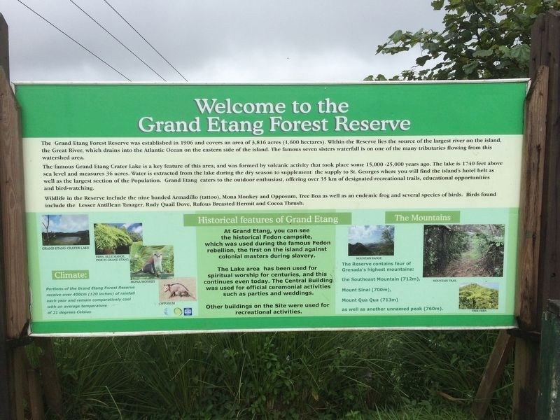
Welcome to Grand Etang Forest Reserve The Grand Etang Forest Reserve was established in 1906 and covers an area of 3,816 acres (1,600 hectares). Within the reserve lies the source of the largest river on the island, the Great River which . . . — — Map (db m135233) HM
On Maurice Bishop Memorial Highway just west of Dr. Grooms Road, on the left when traveling west.
This plaque expresses the gratitude of the Grenadian people to the forces from the United States of America and the Caribbean, especially those who sacrificed their lives in liberating Grenada on 25 October 1983. It was dedicated by President Ronald . . . — — Map (db m134953) WM
Near Richmond Hill just north of Creighton, on the right when traveling north.
Welcome to Fort Frederick – one of the few forts in the world which has never fired a shot in anger. It was built by the French, who had wrested the island from the British in 1779. The French realized that had such fortifications existed at the . . . — — Map (db m135228) HM
Near Richmond Hill just north of Creighton, on the right when traveling north.
In the Bowels of the Fort This fort has a maze of underground tunnels and passageways, plus an extensive waterworks system. Look at the size of the stones. These tunnels offered an easy means of underground communication, allowing soldiers . . . — — Map (db m135229) HM
On Monckton Street at Young Street, on the left when traveling north on Monckton Street.
While the museum’s structure is, indeed, an historic artifact, the museum’s collection offers a variety of objects emphasizing the island’s past. Relics from native Indian populations provide a glimpse into early history while flora and fauna . . . — — Map (db m135193) HM
On Wharf Road just west of Tanteen Road, on the right when traveling west.
This corner stone was laid by the President of the Grenada Seamen and Waterfront Workers’ Union Bro. Arthur Ramsay on the occasion of the 25th Anniversary of the Union on the 1st. May 1977. — — Map (db m135182) HM
On Market Hill just east of Grenville Street, on the left when traveling east.
Historic Sedan Chair Portico This portico is the actual front entrance of this building for sedan chairs. In the 19th century, during early British colonial rule in Grenada, the sedan chair was a major mode of transportation used by the free . . . — — Map (db m135206) HM
On H.A. Blaize Street just east of Bain Alley, on the right when traveling east.
Marryshow House This structure was once the home of T. Albert Marryshow, better known as The “Father of the Federation.” This West Indian statesman promoted the formation of one nation from all of the West Indies. Aside from its . . . — — Map (db m135227) HM
On Lagoon Road just east of Paddock Road, on the left when traveling north.
Port Louis (1650) Grenada’s First Town On June 20th 1650 the French colonist led by Du Parquet, Governor of Martinique landed in this area and set up the first town which was called Port Louis. Project by: Kids Learning Center Sponsored by: . . . — — Map (db m135180) HM
On Church Street at St. John's Street, on the right when traveling north on Church Street.
Roman Catholic Cathedral Located on Upper Church Street, this church reflects several dates of construction. The tower, constructed in 1818, is the oldest part of the building. The remaining portion was built in 1884 on the site of an 1804 . . . — — Map (db m135225) HM
On Market Hill just east of Grenville Street, on the left when traveling east.
Sedan Porches These porches were popular in the seventeenth and eighteenth centuries when sedan chairs were a form of transportation. The porches, open on two sides, would shelter passengers from bad weather when they were embarking or . . . — — Map (db m135205) HM
On Grand Etang Road just south of Young Street, on the left when traveling south.
St. Andrew’s Presbyterian Kirk Popularly known as the Scots’ Kirk, this structure sits at the end of the Church Street. It was constructed in 1831 with assistance from the Freemasons. Two features for which the church is well known are its . . . — — Map (db m135203) HM
Although not located on Church Street, this structure has the distinction of being the oldest original church building in St. George's parish. It was constructed in 1820 and is still in use today. This brick structure, with simple brick buttresses . . . — — Map (db m94081) HM
On Monckton Road just south of Young Street, on the left when traveling north.
Antilles Hotel This structure, one of Grenada’s oldest, is in part one of the former French military barracks constructed in 1704. From 1767 to 1880 the British used portions for a prison. Shortly after, the upper floors became the island’s . . . — — Map (db m135201) HM
In everlasting memory of Prime Minister Maurice Bishop Fitzroy Bain ∙ Norris Bain ∙ Evelyn Bullen ∙ Jacqueline Creft ∙ Keith Hayling ∙ Evelyn Maitland ∙ Unison Whiteman Andy Sebastian Alexander ∙ . . . — — Map (db m135186) HM WM
Near Richmond Hill just north of Creighton, on the right when traveling north.
Backwards Facing Forts The gun ports on this unique fort face inland, rather than to seaward from where an attack on the island would have been expected. This is because of the lesson learned by the British in 1779 when the French took the . . . — — Map (db m135230) HM
As St. George's University's first Vice Chancellor (1978 - 1988), Geoffrey H. Bourne established the academic credentials that the medical school maintains to this day. His drive to firmly shape the newly established medical school according to . . . — — Map (db m94504) HM
Near Belmont just west of Tivoli, on the right when traveling west.
Mona Monkey (Cercopithecus mona) They were introduced to Grenada as pets, from West Africa during the slave trade in the late 1600s. They are primarily found in rainforests, like Grand Etang, towards the middle and top of the trees. . . . — — Map (db m135232) HM