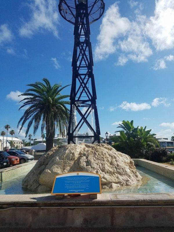
1960 The North Rock is an isolated outcrop marking the outer edge of the reefs of Bermuda. Since the wreck of the BONAVENTURE in 1593 it has been the graveyard of many ships. In 1912 a beacon was erected on North Rock as a warning to navigators and . . . — — Map (db m107322) HM
A Victualling Yard is an essential part of any naval facility. It is the area concerned with the storage, preparation and packaging of food and drink for the Fleet. The Victualling Yard in Bermuda is surrounded by a wall with only two gated . . . — — Map (db m107315) HM
The Broad Arrow, or "crow's foot", is the traditional symbol of British military property and is found throughout Bermuda on milestones and boundary stones, several fine examples of which are on display at the Maritime Museum. The Broad Arrow is . . . — — Map (db m241708) HM
Built in conjunction with the Great Eastern Storehouse, this warehouse contained the offices of the Chief Engineer of the Dockyard. The weighbridge for the Yard can still be seen at the northern end of the building. The roof catchment, like those of . . . — — Map (db m107317) HM
In Memory of the American Prisoners of the War of 1812 who died in Bermuda
Jean Baptiste · James Boon · Peter Burn · Richard Dale · Joseph Darby · William Demers · Thomas Dunton · Charles Gerlock · Howe Hanson· Hugh Hendrik · Samuel Henry · . . . — — Map (db m163619) HM WM
The back garden of the First Government House was on this site. In 1700, Samuel Day, governor, erected this building. For more than a century, it was in possession of the Tucker Family. During the American Civil War it was occupied by the agent of . . . — — Map (db m106350) HM
To the Glory of God in respectful memory of John Till (1781 – 1829) Senior Warden of this church 1810 to 1825 and Mayor of the Town of St. George 1819 to 1823. He is remembered especially by the townspeople for installing the clock in the church . . . — — Map (db m106359) HM
In this building then known as Stennett’s Hotel died on February 22, 1815 in his twenty-first year, Midshipman Richard Sutherland Dale, of the American frigate, President, severely wounded when that vessel, commanded by Commodore S. Decatur, . . . — — Map (db m106348) HM
Pilot James Darrell was an extraordinary Bermudan and mariner who spent much of his life as a slave. At age 47, Pilot Darrell was granted his freedom in recognition of his skill navigating the Royal Navy flagship HMS Resolution through the Narrows . . . — — Map (db m166462) HM
In commemoration of the settlement of these islands on the 28th of July 1609 and in honor of Admiral Sir George Somers Kt. at whose instance largely the settlement was effected. This memorial has been erected out of a grant made by the legislature . . . — — Map (db m106353) HM
1779 – 1858 Irish Poet and Lyrist Byron’s Friend That little bay, where winding in from ocean’s rude and angry din. The billows missed the shore, and then flow calmly to the deep again. — — Map (db m106355) HM
Mr. William Burton Astwood built this house in the 1870, yet he never lived in it himself. Currently it is occupied by his grandson, Mr.XXXX Crofton, who is the island's oldest citizen at the age of 91. Mr. Crofton has lived there all his married . . . — — Map (db m40296) HM
This Lodge was set up in 1855 by the first president
of the Turks & Caicos Islands, Mr. Frederick Forth,
and was called the 'Turks Islands Forth Lodge.' Mr.
Forth, himself, was a member and local legend has
it that President Forth may have . . . — — Map (db m40274) HM
During the colonial days, hundreds of shipwrecks occured off Grand Turk due to the shallow reef off its northern coast. Because shipwrecks were so common, vessels began refusing to call for salt cargoes, the mainstay of the Grand Turk economy. Both . . . — — Map (db m40367) HM
During the Lighthouse's first forty years of use, wrecks continued along the northern coast. Ship captains complained that the light was too dim or not lit at all. Some believe that the dimming of the light was done intentionally to cause ship . . . — — Map (db m40454) HM
The exact location of Christopher Columbus' first landfall in the New World in 1492 has been debated for centuries. Columbus' original journal of his first voyage to the New World is lost, and we will likely never know for sure.
Recent theories . . . — — Map (db m40544) HM
Also owned by the Grant family, this building that dates back to the 1890s was probably acquired at the same time as the Iron Building. This building was a meeting place for the various workmen and merchants of the town where they used to drink and . . . — — Map (db m40297) HM
Lookout Point is named in honor of British Admiral Horatio Nelson who fought for Grand Turk's liberation from French occupants in March 1783. The French occupied Grand Turk for a short time and famed Horatio Nelson led a daring but failed attack to . . . — — Map (db m40663) HM
The Grand Turk Lighthouse had two keepers, the Principal and the Assistant. It is believed that before 1890 the keepers may have lived on location at the site of the present-day Pavilion. Meals were prepared in the separate Bermuda Kitchen, typical . . . — — Map (db m40793) HM
This house, also owned by the Grant family, was never lived in as a family home. It always was rented out primarily to the managers and employees of Cable and Wireless prior to the building of the Cable & Wireless houses on the site of Mr. B.C. . . . — — Map (db m40288) HM
[Exhibit #1 and #2]
Replica of Friendship 7 capsule that carried John Glenn on his historic orbital flight of Feb. 20, 1962. The capsule was 9 feet long and 6 feet across at its base. At reentry it weighed about 3,000 pounds. Space . . . — — Map (db m80425) HM
This church was first built as a ‘chapel of ease’ in 1900 to accommodate the parishioners of Cockburn Town. At that time, St. Thomas’ Church, which was the first church in Grand Turk, was quite a distance from the town and made it particularly . . . — — Map (db m30674) HM
This house, which always has been known as Sunnyside, was originally located on a cay off South Caicos called Sail Rock Cay. It was built in the 1870s and has the distinction of being one of the most famous houses on Front Street. It was moved board . . . — — Map (db m30404) HM
The western side of Grand Turk is the leeward side of the island. This is the side protected from high winds and storms. Because of this, it was the primary anchorage for the sailing vessels that came and went from Grand Turk for hundreds of years. . . . — — Map (db m40351) HM
The Northeast Reef is a shallow reef lying to the northeast of Grand Turk and running 2.8 miles into the sea. The Reef lies in the Turks Island Passage, which has been located along trade routes from Jamaica, Cuba and Hispaniola back to Europe since . . . — — Map (db m40602) HM
Built in the 1860s, this building started life as a salt warehouse belonging to the Stubbs family who were the foremost plantation owners in the Caicos Islands and one of the foremost salt families of South Caicos and Grand Turk. On Grand Turk they . . . — — Map (db m40293) HM
Todds, which was built in the 1880's, not only is the oldest variety store in the island, but also the only one still trading under its almost-original name and owned by the same family. The store was first owned by the Stubbs family who were the . . . — — Map (db m31453) HM
In 1841 a Brigantine ship sailing under Spanish papers left Africa with an illegal cargo of 193 Africans. The ship was the Trouvadore and it was sailing for Cuba, where the Africans were to be enslaved and put to work on sugar plantations. . . . — — Map (db m40764) HM
In 1954 the U.S. Navy established a hydrographic research station on this northern promontory of Grand Turk, overlooking the strategic passage from the Atlantic Ocean. Quonset huts were erected to accommodate eleven officers and one-hundred enlisted . . . — — Map (db m40833) HM
The Library was built in 1887 - the year of Queen Victoria's Golden Jubilee - on the old parade ground used by the local militia, yet it was not completed until 1889. It was reputed to have cost UK £568. Public events such as cultural concerts are . . . — — Map (db m30354) HM
Nick Name Blackbeard
Ship Queen Anne's Revenge
Background
Blackbeard's early life is not well documented, but he was likely born
between 1680 and 1685 to a wealthy family in Bristol. An important
seaport in . . . — — Map (db m219861) HM
On the southern fringe of the Caicos Bank, blow the azure waters you se before you, rests an ancient ship known only as the 'Molasses Reef Wreck'. The oldest shipwreck ever found in the Western Hemisphere.
Having succumbed to the ocean in . . . — — Map (db m219631) HM
Once called "the richest and wickedest city in the world", Port Royal
became the headquarters city for Pirates in the Caribbean. To it came
men of all races. Treasures of silks, doubloons and gold from Spanish
ships, looted on the high seas by . . . — — Map (db m219778) HM