City of Berkeley Landmark
designated in 1994
“To Inculcate the Highest Standards and Ideals in Business.”
That lofty aim, incised high on the façade of this graceful Spanish Colonial building, guided Armstrong College for more . . . — — Map (db m54513) HM
City of Berkeley Landmark
designated in 1978
James Loring Baker was an early Berkeley landowner, developer, and civic leader. He was one of the signers of the incorporation papers for the Town of Berkeley and it was he who delivered them to . . . — — Map (db m54332) HM
Chinaka Hodge
class of 2002, started writing and
performing poems as an awkward, pimply,
BHS freshman, and art-making
saved her life. She is a playwright,
poet and performer.
Phil Lesh
class of 1957, played the trumpet while
at . . . — — Map (db m154873) HM
1939-1940
City of Berkeley Landmark
designated in 1982
These buildings are fine examples of the Art Deco style in the Bay Area. They were designed as an ensemble with the adjacent Berkeley High School Community Theater. Bas-reliefs and . . . — — Map (db m54218) HM
James W. Plachek, Architect, 1930
Addition, Ripley/BOORA Architects, 1999
Listed on the National Register of Historic Places
Berkeley’s first free public library system was established in 1895, with branches in west and south Berkeley. The . . . — — Map (db m52364) HM
Originating among working class Englishmen in 1844, the Young Men's Christian Association was brought to North America in 1851 to promote a "full and balanced life" through religious devotion and athletic activity. Berkeley's charter organization . . . — — Map (db m50295) HM
Listed on the National Register of Historic Places
For nearly a half century, this steel frame and concrete structure, clad in brick and terra cotta, was Berkeley’s only “skyscraper.” Walter Ratcliff, highly respected for his fine . . . — — Map (db m52316) HM
City of Berkeley Landmark
designated in 1991
Berkeley’s Elks Club, the 1002nd Chapter of the Benevolent and Protective Order of Elks, was founded in 1905, just in time for members to assist those displaced by the 1906 San Francisco Earthquake. . . . — — Map (db m54262) HM
City of Berkeley Landmark
designated in 2006
This reinforced concrete building with its articulated brick facade and simple classical detailing was built for Harvey and Marie Ennor at a time of energetic downtown development. They expanded a . . . — — Map (db m54337) HM
City of Berkeley Structure of Merit
designated in 2000
William Wharff, Architect, 1909
Renovation, The Bay Architects, 2001
During Berkeley's early 20th-century development boom, the F.D. Chase Real Estate
Company constructed this . . . — — Map (db m174424) HM
City of Berkeley Landmark
designated 1985
The Farm Credit Administration built this structure to house federal agricultural banking and financial agencies, including one of the 12 Federal Land Banks that assisted Depression-era farmers. Features . . . — — Map (db m54258) HM
Berkeley’s large immigrant population in the late 19th and early 20th centuries included many natives of Sweden. The local chapter of the Swedish-American Vasa Order constructed this building as a lodge hall and cultural center. On November 8, . . . — — Map (db m52386) HM
Stone and Smith, Architects 1901
Jim Novosel: The Bay Architects 1998
Berkeley’s transit pattern was established in 1876 when Francis Kittredge Shattuck and James L. Barker brought a spur line of the Central Pacific (later Southern Pacific) . . . — — Map (db m52378) HM
City of Berkeley Landmark
designated in 1986
g. Paul Bishop Studio
Carl Fox, Designer
Fox Bros., Builders, 1938-39
Notwithstanding its steel-sash showcase window, this diminutive . . . — — Map (db m238704) HM
Listed on the National Record of Historic Places
In 1877, English immigrant John G. Wright founded the Golden Sheaf, Berkeley's first wholesale/retail bakery. The original bakery, with a public dining room, stood around the corner on Shattuck . . . — — Map (db m50360) HM
James W. Plachek, Architect 1917
Jim Novesel: The Bay Architects 1994
This small commercial building was built for William Heywood, son of Berkeley pioneer Zimri Brewer Heywood. The upstairs was used as the architectural offices of James W. . . . — — Map (db m52382) HM
City of Berkeley Landmark
designated in 1983
This Zig-Zag Moderne building, designed for the sale and servicing of Buick automobiles, captures the glamour, rising affluence, and sophistication of the post-World War I era. Charles Howard, who . . . — — Map (db m54334) HM
In Memoriam
Jos. H. McCourt
1877 – 1900
Co. F. 8th Cal Inf. U.S.V. – Co. I. 35th Inf. U.S.V.
———
Bruno L. Putzker
1880 – 1899
Btry. K. 3rd U.S. Army
Berkeley men killed in action in . . . — — Map (db m52400) HM
Charles Dickey, whose firm designed the Claremont Hotel and who practiced architecture extensively in California and Hawaii, designed this building with two residential floors above commercial storefronts. From 1921 to 1935 the ground floor was . . . — — Map (db m52313) HM
In 1876 the Central Pacific (later Southern Pacific) Railroad expanded into downtown Berkeley. What is now Shattuck Square was the site of freight yards; Berkeley Station was located on the smaller block to the south. By 1903, as the business . . . — — Map (db m52384) HM
Samuel H. Kress began his chain of retail stores around 1900 and soon these “five and dime” variety stores dotted downtowns across America. Kress’s own company architects designed stores of high quality and adapted them to fit into the . . . — — Map (db m52380) HM
Shattuck Square is a group of three buildings constructed on the site of a former railroad freight yard, as a northern anchor to Berkeley’s historic downtown commercial district. It is the city’s only work by the San Francisco architectural firm . . . — — Map (db m52391) HM
In the 1940s painter David Park (1911-1960) had a studio in a brick building that once occupied this site. Despite a well-received exhibition of his abstract expressionist works at the San Francisco Museum of Art in 1948, Park rejected abstraction . . . — — Map (db m52388) HM
City of Berkeley Landmark
designated in 1998
By 1900, downtown Berkeley had developed around Shattuck Avenue, its main street. On this site, owned by John Hinkel, stood a brick livery stable run by John Fitzpatrick, the early operator of the . . . — — Map (db m54346) HM
An apple orchard, two houses, and a tailor shop once occupied this block. In 1879, six local businessmen and a university professor financed the purchase of part of the block near Oxford Street as the site for one of the city’s first public schools. . . . — — Map (db m54336) HM
On the morning of September 17, 1923, a grass fire spread from Wildcat Canyon over the hills into Berkeley. Driven by hot, dry winds, the fire spread rapidly across the northeast residential districts of the city, burning as far south and west as . . . — — Map (db m54213) HM
City of Berkeley Landmark
designated in 1984
John Tupper and Lawrence Reed constructed this building for their music store, which they had established in Berkeley in 1906. University of California art professor Eugen Neuhaus complimented them . . . — — Map (db m54507) HM
City of Berkeley Landmark
designated in 1980
Berkeley’s elegant Main Post Office is representative of the Second Renaissance Revival style, also called Neo-Classical Revival. Government buildings constructed in this era were designed to . . . — — Map (db m54260) HM
In the early 1920s Alameda County voters approved a special tax to construct buildings that would honor war veterans and provide a meeting place for their organizations. The City of Berkeley contributed the land for this building. Designed in the . . . — — Map (db m52399) HM
From 1885 to the end of his life his home stood about fifty yards east of this spot
"He who is a blessing for his time is a blessing for all time" — — Map (db m174416) HM
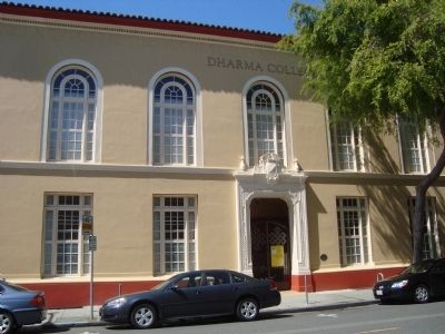
This compact complex of buildings linked by a series of arcades and academic quads in the English tradition was created to house one of Berkeley's oldest seminaries. Hobart Hall, designed by Julia Morgan, is notable for its elaborate brickwork, . . . — — Map (db m50801) HM
Berkeley Repertory Theatre was founded in 1968 by U.C.
Dramatic Art student Michael Leibert, who wanted o create
an East Bay professional repertory company. Its first production, "Woyzek;” initially staged at the International
House, soon . . . — — Map (db m154321) HM
Bill Gulley started "Bill's Model Shoe Shop” here in 1934,
after his previous business enterprise of bootlegging ended
with the repeal of Prohibition. When he died in 1966, his
daughter, Mary Jane "Peggy” Casey, and her daughters . . . — — Map (db m154320) HM
This park honors the memory of
Frances Elizabeth Willard
1839 - 1898
Feminist
Founder of the Women's Christian Temperance Union
Fighter for women's rights and free public education
First woman college president
First Dean of . . . — — Map (db m239025) HM
City of Berkeley Landmark
designated in 1982
John and Margaret Gorman moved their furniture and upholstery shop to this location in 1880. It is one of Berkeley's oldest commercial buildings and a surviving example of the . . . — — Map (db m29371) HM
City of Berkeley Landmark
designated in 2005
This corner store was built for Stella King’s dry goods business and upstairs residence. Until the shop closed in 1923, it was a gathering place where neighbors could find everything from sewing . . . — — Map (db m54722) HM
Robert Agers constructed this building to manufacture "the very best soda water" for customers throughout California. The recessed storefronts, second-floor oriel windows, and high false front are all largely unchanged from a 1904 expansion. The . . . — — Map (db m29383) HM
City of Berkeley Landmark
designated in 1982
Built as the Strand Theater in the Art Nouveau architectural style, this was one of the neighborhood’s first commercial structures. Admission was ten cents for adults, five for children and the theater . . . — — Map (db m54813) HM
On a once rural site now bordered by Russell Street, College Avenue, and Stuart Street, the Kelsey family planted orchards and grew ornamental plants on land they purchased in 1860. The 24-acre Kelsey Ranch supplied trees and plants for the grounds . . . — — Map (db m54691) HM
The Rose Garden was a joint creation of the City of Berkeley and the Federal Works Progress Administration (WPA), whose public works provided employment during the Depression. Vernon M. Dean, the City's landscape architect, designed the garden in a . . . — — Map (db m18618) HM
By the late 1960s, a new generation of political activists emerged in Berkeley from protests opposing the
Vietnam War and supporting the Farmworkers, Free Speech, and Civil Rights movements. In May 1968, in an
apartment on this site, Yuji Ichioka . . . — — Map (db m154322) HM
City of Berkeley Landmark
designated in 1992
Arriving in Berkeley from Massachusetts, Edward Brakenridge bought property that extended to Rose Street for this large Queen Anne-style residence, a stable, and a carriage house. Ira Boynton, like . . . — — Map (db m54512) HM
City of Berkeley Landmark
designated in 2004
The Hillside Club was founded in 1898 by Berkeley women intent on preserving the natural beauty of the hills. It soon became an influential cultural force. North Berkeley’s curved streets with old . . . — — Map (db m54186) HM
Live Oak Park was created in 1914 when the City of Berkeley purchased four acres from landowners R.S. Penniman and Michael O’Toole. Mr. Penniman’s brown shingle house served as the park clubhouse and also, from 1916-1936, as Berkeley’s North Branch . . . — — Map (db m194669) HM
City of Berkeley Landmark
designated in 1999
When architect James Plachek was hired at the age of 29 to design this church, it was his first major commission in Berkeley. He later designed many public and commercial buildings, including the . . . — — Map (db m54187) HM
A revolution began here in 1966 when Alfred H. Peet (1920-2007) opened his first coffee roastery and store. Arriving in San Francisco in 1955, “Mr. Peet” was dismayed by the poor quality of coffee in his adopted country. He had learned . . . — — Map (db m54188) HM
City of Berkeley Structure of Merit
designated in 1988
German immigrant George Hunrick built one of Berkeley’s many neighborhood groceries on this site when the north Berkeley hills were in an early stage of development. In those days before home . . . — — Map (db m54189) HM
In 1858, prosperous farmer Napoleon Bryne sold his Missouri land and journeyed west with his wife Mary Tanner Byrne, four children and other relatives. Two freed slaves, Pete and Hannah Byrnes, came with the family and became Berkeley’s first known . . . — — Map (db m54728) HM
This garden honors Berkeley’s many innovative poets, poetry presses and publications, and their creative legacy. It was dedicated in 1999 on the second anniversary of “Beat” poet Allen Ginsberg’s death. Through their writings, the nonconformist . . . — — Map (db m54191) HM
City of Berkeley Landmark
designated in 1984
This reinforced concrete Moderne-style building replaced an 1892 wood frame school. Faculty of the original school planted the five Coast Redwoods at the southwestern edge of the school grounds. The . . . — — Map (db m54192) HM
Here a venerable oak tree was saved by Annie Maybeck (1867-1956), wife of architect Bernard Maybeck. She is said to have "marched off to city hall" to protest the cutting of native trees during street paving early in the 20th Century. She and other . . . — — Map (db m18562) HM
City of Berkeley Landmarks
designated in 1986
Allenoke is the only large estate remaining near the northern edge of the University of California campus. It was designed by Ernest Coxhead for Allen Freeman, President of the Bank of Oakland. . . . — — Map (db m53888) HM
City of Berkeley Landmarks
designated in 1986
When prominent educator Benjamin Ide Wheeler became president of the University of California in 1899, he and his wife built this spacious home. They entertained many dignitaries here, including . . . — — Map (db m53890) HM
City of Berkeley Landmarks
designated in 1983
In the late 1890s a group of concerned women formed the Hillside Club to “encourage artistic homes built of materials complementing the natural beauty of the Berkeley Hills.” The Club soon . . . — — Map (db m53886) HM
City of Berkeley Landmarks
designated in 1996
This is one of the earliest houses built in the north Berkeley hills. George Jensen came from Denmark and was a contractor in Los Angeles before moving to Berkeley. Members of the Jensen family lived . . . — — Map (db m53887) HM
Robert Hale Merriman, a UC Berkeley graduate student studying economics during the early 1930s, was among the first Americans to give his life in the fight against fascism. During the Spanish Civil War, Merriman was a commanding officer of the . . . — — Map (db m152785) HM
No pivotal battles that changed the course
of history were fought here. Nary a famous
person was ever born or raised, lived, slept,
dined, or even gave a glancing look at this
place. This location did not provide a monumental role in the . . . — — Map (db m147452) HM
This building, thought to be Berkeley’s oldest remaining structure, originally stood on the Contra Costa Road, now San Pablo Avenue. Built by Captain William J. Bowen when the area was sparsely populated, it served as an inn, saloon, grocery . . . — — Map (db m53831) HM
This is Berkeley's oldest remaining church building and the oldest church in the East Bay still in continuous use by its founding congregation. The one-story Victorian Gothic-style building was built here on what was Bristol Street, before it was . . . — — Map (db m28503) HM
(Rehabilitated and Partially Reconstructed in 1986. William Coburn, Historic Architectural Consultant)
In the 1850s, Gold Rush-era farmers and merchants began settling in this rural bayside area. Delaware Street connected Jacob’s . . . — — Map (db m52299) HM
City of Berkeley Landmark
designated in 1985
Built by a real-estate developer during the East Bay building boom that followed the 1906 earthquake, this corner store anchored the southwestern boundary of the neighborhood once known as Regents . . . — — Map (db m53833) HM
The whaling gun below this plaque came off the ship; “Cody.” Gib Hunter was the Captain of the ship and was the last of the whalers to operate off the West Coast. Captain Hunter presented this whaling gun to Bud Spenger. — — Map (db m155984) HM
Clam chowder, baked beans and 10¢ beer – these and fish dinners drew crowds to fabled Spenger’s. It all began in the 1860s when Johann Spenger from Bavaria started fishing in the Bay. The gabled structure he built here housed his business and . . . — — Map (db m52303) HM
City of Berkeley Landmark
designated in 1979
Toward the end of the 19th-century, a large Finnish immigrant community was located in west Berkeley. Together they constructed this wooden building which integrates traditional Finnish and American . . . — — Map (db m53834) HM
City of Berkeley Landmark
designated in 1986
Over the years this complex housed Cooper Woodworking, the Sperry Flour Company, the American Photoplayer Company, and other industrial and manufacturing enterprises. American Photoplayer manufactured . . . — — Map (db m53818) HM
City of Berkeley Landmark
designated in 1977
Listed on the National Register of Historic Places
This small-scaled complex of one-and two-story buildings is a surprise on a busy street. Arranged along a brick walkway through a garden court, . . . — — Map (db m53829) HM
From 1902 to 1979 the Santa Fe railroad company used this land for both industrial shipping and passenger
service. The railroad tracks that once passed through here were part of a nine mile strip of land that went from
Richmond to Oakland. After . . . — — Map (db m153776) HM
City of Berkeley Landmark
designated in 2001
During the early 20th century, the Santa Fe Railroad provided three-day passenger and freight service between Chicago and the Bay Area. This depot was one of three major rail stations in Berkeley. . . . — — Map (db m53828) HM
Always go with nature, anywhere, in any circumstance, with gratitude.
The renowned and highly respected Japanese American artist Chiura Obata was a popular member of
the faculty at the University of California, Berkeley from 1932 to . . . — — Map (db m122842) HM
From 1947 to 1968 this was the home of William Anthony Parker White (1911-1968),
universally known by the pen name Anthony Boucher. This Oakland-born author with a
master's degree from UC Berkeley was a pivotal figure in the establishment and . . . — — Map (db m136180) HM
was a college football star at the
University of San Francisco and #1
NEL draft pick but lost the chancce to play
pro football when he suffered a career-
ending knee injury during a college all-
star game. Instead he became the
first African . . . — — Map (db m145994) HM
City of Berkeley Landmark
designated in 1993
Entomologist, naturalist, physicist, and inventor Charles W. Woodworth designed and built this all-redwood house in the Bay Region style. The three-level, seven-bedroom home has a brown shingle . . . — — Map (db m54877) HM
This building was originally part of the small commercial district that grew up around Dwight Way Station where Shattuck Avenue commuter trains intersected with the horse-car line that ran up Dwight Way to the California Schools for the Deaf and . . . — — Map (db m29581) HM
This landmark commemorates an all but forgotten community called
Newbury and a pioneer carpenter, Josiah John Rose, builder of many
San Francisco and Berkeley homes. Newbury, annexed later in 1891
by Berkeley was a thriving village. The sidewalks . . . — — Map (db m145339) HM
William C. Hays, Architect, 1922
James W. Plachek, Architect, 1930
John Reid, Jr., Architect, 1935
ELS/Elbasani & Logan Architects, 1998
As electric streetcar transportation improved and expanded in the early 20th-century, this section . . . — — Map (db m53873) HM
Hiram Lovell, Architect, 1910, 1914
James W. Plachek, Architect, 1921
The popularity of early movies created a demand for new spaces to accommodate eager audiences. South Berkeley’s first neighborhood theater with 144 stools for seats was . . . — — Map (db m53816) HM
Founded in 1945 by local sports hero Melvin Reid and his wife Betty Reid, Reid’s Records was one of the first Black-owned record shops in California and one of the few shops of any kind where African-American music could be purchased before the . . . — — Map (db m152805) HM
City of Berkeley Landmark
designated in 1982
In the early 20th century, this was one of two banks anchoring the busy Lorin business district’s streetcar intersection. The building remained a bank until the 1980s. Its architecture combines a . . . — — Map (db m53815) HM
Berkeley History
Horse-drawn wagons once carried goods to the Berkeley Free Market housed here. In 1952 the structure was modernized to accommodate automobile showrooms, with artist studios above. Richard Diebenkorn, Elmer Biscoff, William . . . — — Map (db m54333) HM
William Byron Rumford was a phamacist who worked on this very
block. In 1948 he was elected to the California
State Assembly becoming the first African
American elected to any public office in Northern
California. He took the lead in passing . . . — — Map (db m154349) HM
Mural designed by Osha Newmann, painted with O’Brien Thiele, Janet Kranzberg, Daniel Galvez and many others
Painted in 1976
Restored and enlarged in 1999
City of Berkeley Landmark
designated in 1990
The mural on this wall was painted . . . — — Map (db m54696) HM
The Berkeley City Club, organized in 1927, was one of the area’s earliest attempts by women to social, civic and cultural progress. The building, constructed in 1929, is one of the outstanding works of noted California architect Julia Morgan, . . . — — Map (db m100562) HM
City of Berkeley Landmark
designated in 2005
The Berkeley Piano Club, dedicated to the performance and study of music, was founded in 1893 by a group of local women. Early meetings were held in members’ homes and later in a barn at the . . . — — Map (db m54726) HM
Roof replacement, accessibility, and seismic improvements: Architectural Resources Group and Degenkolb Engineers, 2007
City of Berkeley Landmark
designated 1975
Maybeck’s masterpiece is an Arts & Craft fusion of Romanesque, early Christian . . . — — Map (db m55032) HM
City of Berkeley Landmark
designated in 1981
Fred Turner Building
Julia Morgan, Architect
Christian M. Teigland, Builder, 1940
This elegant commercial building, featuring two projecting storefront bays, . . . — — Map (db m238722) HM
The McCreary-Greer House and neighboring turn-of-the-century houses on this block are survivors of one of the first residential districts developed around the University campus. This house, with its original garden area and carriage house, . . . — — Map (db m52300) HM
In 1959, Morris (Moe) Moskowitz and his wife, Barbara, opened a small paperback
bookshop on Shattuck Avenue. They soon moved to Telegraph Avenue where Moe's
Books evolved into a renowned emporium featuring hundreds of thousands of books.
Moe's . . . — — Map (db m136179) HM
During the summer of 1969, the house at
835 Folger Avenue was home to the band
Commander Cody and his Lost Planet Airmen.
The band's style mixed country, rock 'n' roll,
western swing, rockabilly, and jump blues
together on a foundation of . . . — — Map (db m239011) HM
This station was constructed as an
Exxon Super Service Station in 1933.
It was a business venture of
longtime Berkeley elementary
school teacher, Sue Irwin.
Built in the California Mission
Style it reflects the look of
railroad . . . — — Map (db m171532) HM
It was just automatic for me to stand up and tell a person, “You’re wrong. You’re mistreating me. You’re discriminatory. Why don’t you give me a chance?”
Great generosity coupled with anger at injustice guided the life of . . . — — Map (db m54814) HM
Berkeley History
Reflecting West Berkeley’s early industrial heritage, this plant remains one of the city’s largest brick buildings. Once used to produce chemicals for a cluster of nearby industries that manufactured soaps, cleaning agents, paper . . . — — Map (db m53812) HM
In the 1930s pharmacist and civil rights activist Dr. William Byron
Rumford (1908–1986) served as the first black professional at
Oakland's Highland Hospital. In 1942 he purchased a pharmacy in
Berkeley and, after constructing this . . . — — Map (db m154343) HM
The San Pablo Tennis Club (SPTC) was established in 1954 by a group of predominantly
Black tennis players who wanted to promote tennis, particularly for the youth, in their
much beloved community. Due to racial discrimination, the San Pablo Park . . . — — Map (db m176624) HM
From the early 1930's the Santa Fe railroad tracks
ran along Sacramento Street in South Berkeley,
through the heart of the African-American community.
This was unsafe and a barrier to unifying
the Berkeley community.
In 1978 Dr. William B. . . . — — Map (db m171589) HM
Originally located at Sixth and Delaware streets, this simple wooden building was constructed by volunteers from the Workingman’s Club, a west Berkeley political organization. Built as a reading room for laborers, it was used briefly as Berkeley’s . . . — — Map (db m53836) HM
These landmarks form the historic core of the first University of California campus, opened in 1873: Founders’ Rock, University House, Faculty Club and Glade, Hearst Greek Theatre, Hearst Memorial Mining Building, Doe Library, Sather Tower and . . . — — Map (db m229323) HM
South Berkeley was originally settled by Coast
Indians. After Spanish conquest in the 1700s, large
land tracts were held by the Peralta, Ashby and
Harmon families.
Transportation has been a key factor in Lorin's
history. Gov. Stanford . . . — — Map (db m145998) HM
11510 entries matched your criteria. Entries 101 through 200 are listed above. ⊲ Previous 100 — Next 100 ⊳