In 1946, Walter Jordan's orchard business had expanded. This building was constructed to house an apple grading machine and other fruit packing operations. Walter Jordan operated the orchards until 1973. — — Map (db m94848) HM
In 1876 or 1877, Jim Thompson built a log cabin here and began cultivating the old Indian Gardens where the Indians had grown corn and squash long before Oak Creek was known to white men. Thompson remained here at his Indian Gardens Ranch until his . . . — — Map (db m33203) HM
Fruit growing played a significant role in the early Sedona economy. Over time, settlers constructed ditches, flumes, pipelines, reservoirs, and water wheels to provide irrigation to their gardens and eventually to their larger orchards.
Apples . . . — — Map (db m54228) HM
Lee Van Deren, cattleman, arrived to put his children in the new Sedona school opened in 1910. Ranching was a major part of Sedona’s early economy. Round ups and cattle drives were a twice a year occurrence for ranchers when moving their herds from . . . — — Map (db m54229) HM
Despite all it had to offer, in time Walnut Canyon became a difficult place for farmers to live. Drier, colder conditions meant crop failures. More people and diminished resources meant nutritional stress, disease, and conflict.
However, these . . . — — Map (db m61370) HM
Nalakihu - A modern Hopi name, "House Outside the Village"
Farmers lived here about 800 years ago. (Roof beams gave tree ring dates in the late 1100s.) The way the walls join show this small pueblo was not built all at once, but was added onto. . . . — — Map (db m41713) HM
Farming then did not mean vast fields like we use today. Anasazi and Sinagua people modified these small terraces to grow hand-tended corn, cotton, beans, and squash. We know the climate was about what it is now, very dry for farming. The terraces . . . — — Map (db m41715) HM
John Henry Thompson, a noted Gila County pioneer, brought his bride, Carrie Louise Nash, to Globe to live in the house he had built on this site, one of the town's early adobe buildings. Thompson was active in mining, cattle ranching and the feed . . . — — Map (db m34119) HM
Gold and silver strikes in the 1860's created growth in the area. It is said Wyatt Earp served as sheriff of Cibola for one year in the 1890's. The town of Cibola formed in 1898 and construction began on a 16 mile canal to bring water from the river . . . — — Map (db m78552) HM
The land surrounding this cemetery represents the beginning of commercial cotton growing in Arizona.
In January 1917, during World War I, the Goodyear Tire and Rubber Company founded the Southwest Cotton Company to begin producing long-staple . . . — — Map (db m34554) HM
He knew no yesterdays
His living was for tomorrow
Founder of the town of Chandler
Built the San Marcos Hotel
Arizona’s first veterinarian
Father of modern irrigation system
Pioneer rancher and developer of the southside area of . . . — — Map (db m70990) HM
Farm and ranch work have always been hard on machinery, making frequent repairs necessary. Throughout Sahuaro Ranch's history, most of these repairs were made here by the ranch's own employees.
This building, which is believed to have been . . . — — Map (db m40676) HM
The corrals here are the remnants of the sprawling complex of corrals and pastures needed to raise the livestock that was always important to the operations of Sahuaro Ranch.
In early years, horses and mules were the primary source of power for . . . — — Map (db m40686) HM
Although some cows were probably always kept on the ranch to supply fresh milk and butter, it was not until after Richard W. Smith bought Sahuaro Ranch in 1927 that dairy cows were raised here commercially.
At first the Smith family sold only . . . — — Map (db m40662) HM
This packing shed, constructed in 1891, is one of the oldest farm buildings on the ranch. It was designed by James M. Creighton, a prominent architect in territoral Arizona.
Exactly how the shed was used is not known, but presumably it was here . . . — — Map (db m40702) HM
The water for Sahuaro Ranch came by gravity flow from the Arizona Canal, located about two miles to the north. It was carried from the canal by a ditch on 59th Avenue known as Lateral 18 and then flowed onto the ranch through smaller ditches such . . . — — Map (db m40706) HM
The most important crops in the early years of Sahuaro Ranch were fruits and nuts. These commanded high prices, which meant they could profitably be raised here and sold to buyers across the country despite the high cost of shipping from such a . . . — — Map (db m40705) HM
National Register of Historic Places
Listed March 7, 1980
United States Department of the Interior
Sahuaro Ranch was one of the first farms in the Glendale area and a reminder of Glendale’s agricultural beginnings. Started by wealthy . . . — — Map (db m28088) HM
Little is known about the history of this building, which started out as a horse stable, but it almost certainly was one of the earliest work buildings to be erected at Sahuaro Ranch.
The eastern half, with the vertical wood siding, was built . . . — — Map (db m40685) HM
The barnyard was the center of activity as Sahuaro Ranch. Horses and mules were stabled, trained, and shoed here. Cattle were brought to the corrals for branding, treatment and shipment. Farm implements and wagons were stored and repaired here. . . . — — Map (db m40674) HM
When Sahuaro Ranch was built, and for some years afterward, water and electricity had to be provided by the owners themselves, often at great expense.
Drinking water was obtained from a groundwater well located in the back yard of the Main . . . — — Map (db m40638) HM
Sahuaro Ranch was established in 1886, when William H. Bartlett filed a claim to 640 acres of public land at this site. Using irrigation water delivered by the Arizona Canal, which reached the Glendale area in early 1885, Barlett and his ranch . . . — — Map (db m40656) HM
This building, which houses a groundwater well pump, is a re-creation of a Salt River Project (SRP) pump house from the 1920s. In the original pump houses, a wooden derrick was erected first and used to drill the well. Once the well was working, an . . . — — Map (db m40660) HM
National Register
of Historic Places
Listed April 9, 1998
United Stated
Department of the Interior
Manistee Ranch a treasured Glendale landmark and was the long-time home of Louis M. Sands, a pioneer of modern Arizona cattle . . . — — Map (db m30500) HM
Approximately 300 B.C. Prehistoric Indians entered the Salt River Valley. They developed an extensive canal system and raised corn, beans, squash, agave and cotton.
Over 500 miles of Hohokam canal have been recorded in the Salt River . . . — — Map (db m49877) HM
February 4, 1877 - March 10, 1969
Zebulon "Zeb" Pearce was a leading participant throughout 90 years of central Arizona history. He graduated from Tempe Normal in1899 and later went on to become a teacher, the Mayor of Mesa, city councilman, . . . — — Map (db m204891) HM
Before 1875 hundreds of heroic women came to Arizona from the East and South. From this group came Arizona's first schoolteachers and the publisher of the first newspaper.
In 1876 a group of pioneer women and their families came from the north, . . . — — Map (db m27385) HM
Land that was to become the Story Neighborhood (bounded by McDowell Road, Roosevelt Street, 7th Avenue, and Grand Avenue) was purchased in 1887 and 1906 by Francis Q. Story, a horticulturist known as the "father of the Sunkist Orange." Serious . . . — — Map (db m39413) HM
Jacob Waltz was born in the kingdom of Wurttemberg Germany circa 1810. He immigrated to the USA in 1839 and became a naturalized citizen in 1864. Waltz was prospecting in Arizona and is reputed to have found a gold deposit near the superstition . . . — — Map (db m74397) HM
At this site
in the Spring of 1868
S. (Frenchy) Sawyer
Built the first farm dwelling and harvested the first cultivated crop (barley) in the Anglo-American occupation of the Salt River Valley. These same fertile acres had been irrigated . . . — — Map (db m30402) HM
The Peoria train depot was constructed in 1895 at a cost of $1,455 by the Santa Fe, Prescott and Phoenix Railway Company. The wood-frame structure served the agricultural and ranching interests in Peoria and areas west of Phoenix until 1972. The . . . — — Map (db m126698) HM
b. July 12, 1899 Hope, NM
d. October 25, 1971 Wickenburg, AZ
Known as the cowboy's cowboy
Admired and revered by townsfolk
Father and organizer of Turtle Association 1936 which became the Professional Rodeo Cowboy Association
1937 Owned . . . — — Map (db m29473) HM
Discovered in 1863 by
Henry Wickenburg and his Burro
To supply the needs of the mines and protecting military camps, the Salt River Valley irrigated agricultural industry was developed. The Vulture Mine produced 10 millions in gold and was the . . . — — Map (db m29477) HM
The Tucson Plant Materials Center
Has been placed on the
National Register of Historic Places
By the United States
Department of Agriculture
1997 — — Map (db m31525) HM
Dr. Smith built this house in 1904 in anticipation of his marriage to Maud North, a Tucson teacher. The house, which he designed, was the first building on the north side of Speedway. Dr. Smith was a University of Arizona professor of engineering . . . — — Map (db m83035) HM
Like many Tucsonans in the 1920s, Bernice Walkley and Rutger Porter were transplanted easterners – she from Connecticut and he from New York. Rutger met Bernice while doing landscape work for her father in Tucson.
In 1929 Rutger bought the . . . — — Map (db m84199) HM
This seedling was grown from the very seeds that journeyed to the moon and back on board Apollo 14. It symbolizes the major role forests played in developing our American Heritage and the vital role forests have in our future.
This planting made . . . — — Map (db m83012) HM
Hired Man’s House – Who Lived Here? This two room house was in existence by 1920. Most likely, the Vails built it for use by families working on the Empire Ranch. Dusty Vail Ingram, who grew up on the Empire, recalled that the Estrada . . . — — Map (db m84201) HM
Behind you are many of the original buildings of the historic Empire Ranch, established in the 1870s by Edward Nye Fish on 160 acres with a four-room adobe ranch house and corral.
In 1876, Walter L. Vail and Herbert R. Hislop purchased the . . . — — Map (db m84196) HM
This 1881 Sonoran/Early Transitional adobe was home to the Elmer Coker family in 1907. A prominent cattleman and lawyer specializing in land and water rights. Coker was a delegate to the Arizona Constitutional Convention and is considered the father . . . — — Map (db m26626) HM
Juan Avenenti, an Italian immigrant who came to Arizona about 1870, purchased this property in 1886 from Frank M. Griffen. Previously, it had belonged to Florence pioneers Levi Ruggles and Charles Douglas. Avenenti, a grocer, butcher and rancher, . . . — — Map (db m26736) HM
Established June 14, 1887. A small conical red peak gave Red Rock its name. Red Rock was a major cattle shipping point via the S.P. Railroad. This post office celebrated its
Centennial in June 1987. — — Map (db m31190) HM
Upper Plaque:
Pecan Lane Rural Historic Landscape
Lower Plaque:
Pecan Lane Rural Historic Landscape was added to the National Register of Historic Places on May 2, 2000.
Pecan Lane played a significant part in the . . . — — Map (db m27855) HM
In memory of Wales Arnold.
Co. E, 5th Cal. Vol. Inft.: Scout in
Apache Wars: Post trader at Camp
Verde: Pioneer farmer in Verde
Valley: and of his wife, the
beloved ”Aunty Arnold” of
all the Verde. — — Map (db m100022) HM
In 1890 James and Adeline Hall purchased 130 acres here above the junction of the Agua Fria River and Lynx Creek. The Halls named their homestead "Orchard Ranch" and, with the help of their children, Sharlot and Ted, produced apples and beef. . . . — — Map (db m33059) HM
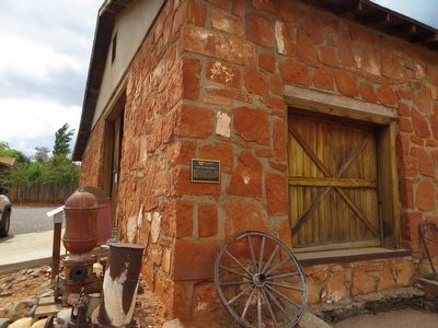
In early times. Uptown Sedona was a patchwork of orchards, homestead and pastures. In the late 1930s, the Jordan’s built a stone building along the highway from which to sell their fruit to the increasing traveler traffic coming down the newly . . . — — Map (db m133575) HM
Sedona’s earliest permanent settlers planted fruit trees as they arrived along Oak Creek. Apples and peaches seemed to grow well along with apricots and plums. Grapevines didn’t take as long to mature as fruit trees so the Schuerman’s planted grapes . . . — — Map (db m133679) HM
From 1857 to 1860 Lt. Edward F. Beale and a crew of 100 men built the first federal highway in the southwest. The 1857 Beale Expedition used 22 camels and dromedaries for pack animals. This road went from Fort Smith, Arkansas to Los Angeles, . . . — — Map (db m32206) HM
Recordando a Brian O'Dwyer In 1994 Brian came to Gowan to build a business in Mexico that would provide growth and opportunity for the company and his employees. Walking the fields with farmers, Brian and his Tribe were men with muddy boots. They . . . — — Map (db m191696) HM
A Positive Impact Starting in 1905, dams were constructed along the Colorado River that brought positive change to the Southwest. Dams and canals brought a safe and secure source of water and power and enhanced the ability of people to live in . . . — — Map (db m158380) HM
Named for resident William Finley Crockett, son of frontiersman Davy Crockett, this community was once a flourishing river port during the second half of the 19th century and into the early years of the 20th century. Steamboats loaded with cotton, . . . — — Map (db m201389) HM
From the 19th century to present day, the economy of Arkansas County has been based on agriculture, especially rice farming. An essential part of rice farming
is having enough water at the right time to flood the fields. Natural water sources . . . — — Map (db m192660) HM
Following the sneak attack on Pearl Harbor on December 7, 1941, the massive American production might was mobilized. After that attack the production of most non-essential consumer goods was halted or curtailed, and manufacturing facilities were . . . — — Map (db m92187) HM
The Arkansas & Oklahoma Railroad, owned by John Bayless and William Felker, was the train route west from Bentonville to Gravette from 1898 to 1900. Besides transporting passengers, this route played a major role in the growth of the Ozark fruit . . . — — Map (db m167938) HM
January 1936, Tom Farish & Joe Steele started building a canning factory using a lot of donated labor. The first run of green beans was June 26, 1936, tomatoes July 22, 1936, followed by spinach and other products later on.
After Tom Farish . . . — — Map (db m93283) HM
The words "esto perpetua" emblazoned upon a stone above the entrance to Grotto Spring declare the prevailing belief that these healing waters would flow forth forever. Early townspeople discovered the spring under an overhanging rock ledge, a . . . — — Map (db m80121) HM
In 1895 Austin Corbin, a New York banker and land developer, working with immigration officials brought 100 families from north central Italy to grow cotton at Sunnyside, a plantation located between the Mississippi River and Lake Chicot. These . . . — — Map (db m89774) HM
Side 1
The Lakeport Plantation house was constructed circa 1859 for Lycurgus and Lydia Taylor Johnson. The skilled craftsmanship and lasting character are testaments to those who built the house. It is preserved in remembrance of all who . . . — — Map (db m90491) HM
The legacy of the Mississippian culture lives forever through the Three Sisters Garden, like the one you see planted here.
The American Indians who lived here over 500 years ago were expert farmers whose most important crops were corn, beans, . . . — — Map (db m116605) HM
The dam seen here was constructed in 1887 & 1888 for the Mammoth Spring Milling Company. Each stone was hand-quarried and fit into place using no mechanical equipment. The concrete structure, to your left on the far side of the dam, is all that . . . — — Map (db m192074) HM
Established in 1855, the Independence County poor farm provided those in need with a place to live, medical care, and the opportunity to grow their own food in the garden patch. These houses were the community’s way of providing care to the poor . . . — — Map (db m226571) HM
A founder of Lafayette County
First governor of Arkansas
In 1823 James Sevier Conway began a successful plantation in the rich soils near the Red River. In 1826 he married Mary Jane Bradley, a beautiful young women who had moved to the . . . — — Map (db m181517) HM
Marianna named in honor of
Maryann Martin Harland
Town established 1858 A.D.
Incorporated Oct. 24, 1870 A.D.
1870 Agriculture, Timber
Population 165
1970 Agriculture, Industry
Population 6215 — — Map (db m117262) HM
(side 1)
The first tracts of South Bend Plantation, originally known as the Jordan Place, were purchased in 1840 by Dr. John Augustus Jordan. In 1852, Jordan and Irene Johnson married and built a stately southern Georgian mansion on the . . . — — Map (db m210445) HM
In the fall of 1851, three Mills brothers
headed west, one by water, one by land and
one to Texas. This brought Joel Mills wife,
Kitura Burke Bird and family from Henderson
Co., Tennessee to Sevier County, now known
as Little River County. . . . — — Map (db m121361) HM
In 1897 on the NW 1/4 Sect. 8 1N 7W Fuller planted the first rice on the Grand Prairie. The venture failed. Having learned about rice production in Louisiana, he returned for more information. In 1903 he returned to Lonoke County. The citizens of . . . — — Map (db m96636) HM
Just as pottery, stone tool, mounds are critical for understanding the Plum Bayou culture, so too are plants.
Through specialized techniques archeologist recover and analyze plant remains from archeological sites like Toltec Mounds. One . . . — — Map (db m213797) HM
Long before domesticated maize and beans were introduced into the Southeast, Indians of Arkansas had begun tending and caring for native plants.
The archeological record of Arkansas demonstrates that by 3000 years ago, people's use of some . . . — — Map (db m213828) HM
Plants of the past rooted early people to this land. European farmers were not the first to cultivate plants
here on these lands. People were here long before who
survived, told stories about, and even celebrated these
humble resources around . . . — — Map (db m215880) HM
1541 - When Desoto brought his Spanish conquistadores to this area in 1541, he found an industrious Caddo Indian tribe who inhabited and enjoyed the area that was later to become Miller County, Arkansas. Along the Red River the Caddo farmed, . . . — — Map (db m173500) HM
Before 1776 this area was inhabited by Indian Mound builders, bayous were the only drainage and there was no flood control, there was an immense forest that consisted mostly of hardwoods and cypress, in the early 1900's drainage districts began to . . . — — Map (db m212074) HM
Established in 1934 by President Roosevelt, Dyess Colony, named for W.R. Dyess of Luxora, became home to 500 families stricken by the Great Depression. Selected on the bases of need, farming knowledge, and physical fitness, these pioneers each . . . — — Map (db m207238) HM
The 10,000-acre Sans Souci plantation established in 1854 by John Harding McGavock, served as a Civil War hospital as the Union fleet docked across from the home. In addition to farming cotton, much acreage was devoted to hunting deer, bear, and . . . — — Map (db m36298) HM
Frank Moore, a WWI veteran buried at Little Rock National Cemetery in 1932, moved to Phillips County, Arkansas, after being honorably discharged in December of 1918 from service as a private in the 162nd Depot Brigade, There he worked on a farm and . . . — — Map (db m210364) HM
Plants affect every aspect of our lives. Without them, life would not be possible.
Crews working for the University of Arkansas Museum recovered this bag in the 1930s from a bluff shelter in Benton County, Arkansas.
Filled to the . . . — — Map (db m213906) HM
"Pocahontas is beautifully situated on the west bank of Black River… As a trading point, it is unsurpassed by any town of its size in the state."
J. C. Martin of Pocahontas
1857
As agriculture in Randolph . . . — — Map (db m170298) HM
The railroad depot was donated to the City of Pocahontas by Michael Parker to honor the memory of his Grandfather,
Mr. Earney L. Dickson
He was a prominent businessman in Randolph County from 1920's until his death in 1974, During his . . . — — Map (db m174944) HM
"We have a large quantity of vacant land in this country … and have room for one thousand good and industrious families, and bread and meat to feed them."
A Pocahontas resident
Jan. 2. 1852
The contemporary riverbank you see here barely resembles the site that fishers, hunters, farmers, and traders visited for 10,000 years. Some native trees are visible, however. Look for black willow and silver maple.
Farmers still grow crops, . . . — — Map (db m170361) HM
"This … region [is] annually covered by water and at all seasons by a heavy growth of timber [and] thick can-brakes."
U.S. Rep. A. H. Sevier of Arkansas
Feb. 21. 1838
The Black River flows through . . . — — Map (db m170376) HM
Stone fruit cellars, like this one, were once popular in the Ozarks. They were designed to keep food cool in the summer months and above freezing in the winter months.
Most were constructed in the 1920s and early 1930s as home canning was . . . — — Map (db m240312) HM
Newly recruited Confederate troops gathered at Elm Springs in 1861 for training. After driving Confederate troops from their winter quarters at Cross Hollows, U.S. pickets occupied the area. Confederates camped here on a bitter cold March 5, 1862, . . . — — Map (db m167935) HM
From 1962-71, UA Agricultural Engineering Professor Xzin McNeal designed, built, tested and developed the nation's first successful pallet trailer system of stacking and storing cotton. His system solved the temporary storage problem created by the . . . — — Map (db m224263) HM
“Arksoy,” the first Arkansas soybean variety,
was developed by agronomy professor
Chalmers K. McClelland and released by the
Arkansas Agricultural Experiment Station in
1928. Agronomist Charles E. Caviness and
plant pathologists H.J. “Jack” . . . — — Map (db m224344) HM
University of Arkansas plant pathologists George Templeton, Roy Smith (USDA), David TeBeest and graduate student Jim Daniels conducted research in the early 1970s that led to Collego™, the first biological herbicide for weed control in a field crop. . . . — — Map (db m224721) HM
In 1951, through what is now the Dale
Bumpers College of Agricultural, Food and
Life Sciences, the University of Arkansas
became the first land-grant institution in
the nation to assemble an agricultural
foreign mission. Developed in concert . . . — — Map (db m224749) HM
City of Berkeley Landmark
designated in 1998
By 1900, downtown Berkeley had developed around Shattuck Avenue, its main street. On this site, owned by John Hinkel, stood a brick livery stable run by John Fitzpatrick, the early operator of the . . . — — Map (db m54346) HM
(Rehabilitated and Partially Reconstructed in 1986. William Coburn, Historic Architectural Consultant)
In the 1850s, Gold Rush-era farmers and merchants began settling in this rural bayside area. Delaware Street connected Jacob’s . . . — — Map (db m52299) HM
Margaret Tehan Dobbel, the granddaughter of Jeremiah and Ellen Fallon. She was born in Jeremiah Fallon’s home, Dublin, 1874. She married Julius Dobbel and had 13 children. They raised cattle and sheep at Rice, Camel, Dougherty and Donlon Ranches. — — Map (db m201556) HM
The Kolb Family settled in Dublin in the 1870’s. George Kolb operated the General Store and farmed. His sons, Edwin and Harold, also ranched and farmed. Harold (H.W. Kolb) was a trustee for the Murray School District for 17 years and was a noted . . . — — Map (db m201563) HM
Peter A. Rasmussen a native of Langeland, Denmark, married Wilhemina Lausten of Slesvig, Denmark whom he met at a local Danish gathering, settled in Dublin in 1871. He worked on the Dougherty Ranch before he bought his own farm on San Ramon Road, . . . — — Map (db m201568) HM
The Kolb’s purchased their first tractor 1943. The introduction of tractors to mechanize agriculture resulted in a reduction of the heavy efforts of plowing and harrowing before planting, which were often backbreaking tasks for human and draft . . . — — Map (db m201560) HM
Originally from Denmark, Peter Nielsen settled in Dublin in the late 1800’s leasing a large tract of land from Dougherty on what is now called the Camp Parks, Dougherty Valley area. His son, Tom, (1865-1956) purchased land in the Silvergate Dublin . . . — — Map (db m201561) HM
When Paul and Louise de Vaux sold their vineyard and winery in 1918 (shortly before Prohibition went into effect), a large part of it was purchased by Otto Hirsch, a locally prominent businessman. He leased the property to dairy farmers for over . . . — — Map (db m212641) HM
The first vineyards in the East Bay were planted at Mission San Jose in the late 18th century, tended by Spanish missionaries and Native Americans. Around 1850, after the Mission was secularized, landowners expended vineyards and began . . . — — Map (db m212653) HM
Boxed Tree Forest
These oak trees were planted in boxes waiting to be sold when the Roedings operated California Nursery Company. Eventually the trees rooted into the ground creating a unique forest of boxed trees. Over the years, local . . . — — Map (db m208707) HM
The historic buildings on the property – the Vallejo Adobe, President’s House, Office Building and Packing Shed - make up the historic core of the site, and were the center of the nursery operation; the place where orders were placed, materials . . . — — Map (db m208904) HM
6584 entries matched your criteria. Entries 101 through 200 are listed above. ⊲ Previous 100 — Next 100 ⊳