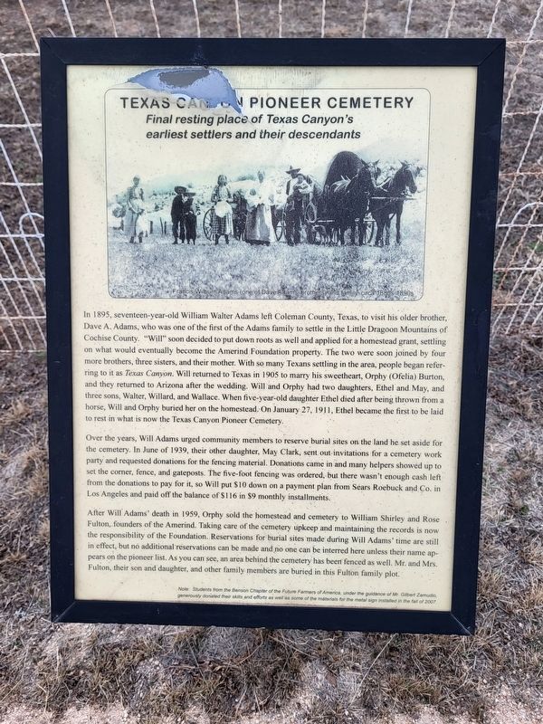
In 1895, seventeen-year-old William Walter Adams left Coleman County, Texas, to visit his older brother, Dave A. Adams, who was one of the first of the Adams family to settle in the Little Dragoon Mountains of Cochise County. "Will," soon decided . . . — — Map (db m216038) HM
Lt. John A. Rucker, 6th Cav. U.S.A. perished in proximity in flooded White River July 11, 1878 attempting to save life of Lt. Austin Henely
Also on this site 1884-1943 ranch headquarters of Gray - Hampe - Rak — — Map (db m42057) HM
Camp Supply served as the base for two companies of Indian Scouts: Company C commanded by 2nd Lieutenant John A. Rucker, and Company D led by 1st Lieutenant Austin Henely. Each Company included between 32 and 40 Scouts who enlisted for 6 months at a . . . — — Map (db m42080) HM
The Bakery was first described in Camp records in May, 1879. It was a log building with an earth roof and an adjacent guardhouse. The nearby storehouse (commissary) was a stockaded tent structure with vertical log walls and a canvas tent roof. In . . . — — Map (db m151079) HM
June, 1876 - The Chiricahua Apache Indian Reservation is abolished. Apaches who are not relocated to other reservations are labeled renegades. Military patrols are sent throughout southeastern Arizona in search of them.
March, 1878 - . . . — — Map (db m42087) HM
Camp Supply became known as Camp Rucker as a result of a tragic incident that took place soon after the camp was established.
On July 11, 1878, a flash flood occurred in White River Canyon (now Rucker Canyon). Lieutenants John A. . . . — — Map (db m151081) HM
Camp Rucker was a ranching headquarters for over 80 years. The first owner was Michael Gray, a Justice of the Peace in Tombstone, Arizona. He moved to Camp Rucker in 1883 under the privileges of a “Squatters Claim.” Gray was strongly . . . — — Map (db m42077) HM
During the Chiricahua Apache Campaign (1861-1886) cavalry troops on maneuvers camped here at a permanent source of water known as Soldiers Hole.
W. C. Sanderson and Ambrose Lyall struck artesian water nearby in 1883.
In 1892 a . . . — — Map (db m28363) HM
This jail, built in 1910, replaced a tiny wooden jail which once stood nearby. Constructed entirely of reinforced concrete, it has withstood a hundred years of weather, escape attempts, vandals, neglect, and pillagers (official and otherwise): It . . . — — Map (db m64206) HM
At this location in 1952, a large bone bed was discovered containing the remains of extinct mammoth, tapir, bison and horse. Found with the bones were the weapons and tools of the Indians who had killed and butchered these animals. The bones and . . . — — Map (db m43633) HM
Spanish:
En el año 1539, recordando aún el anuncio de la conquista del imperio inca que occurrió en 1533, el virrey Antonio de Mendoza receloso pero con te a la vez, envió a un sacerdote para comprobar los rumres [rumores] sobre ricas . . . — — Map (db m28255) HM
Situated on the southern route to the Pacific Ocean, it brought law and order to the Arizona Territory, protecting settlers, miners, travelers and immigrants. Its troops won the surrender of Geronimo. Generals Pershing and Wood served here.
As . . . — — Map (db m27897) HM
The remains of this noted gunman and outlaw lie here. A teamster traveling from West Turkey Creek found the body sitting in the fork of a nearby oak tree with a bullet hole in the right temple.
A coroner's jury reported the death to be suicide, . . . — — Map (db m28365) HM
A Post Office was established in the Pearce Camp in 1896. At that time the Soto Bros and Chattman Store served as the first Post Office location with Thomas Chattman as the first appointed postmaster. The Post Office was later relocated to this . . . — — Map (db m64204) HM
Near here Geronimo, last Apache Chieftain, and Nachite with their followers surrendered on Sept. 6th 1886 to General Nelson A. Miles. U. S. Army. Lieutenant Chas. B. Gatewood with Kieta and Martine Apache scouts, risked their lives to enter the camp . . . — — Map (db m28355) HM
Dedicated to the
Engineering Achievements of
Percy Jones, Jr.
1888 –
Chief locating engineer who by sheer genius personally located more miles of Arizona highways than any other person. His college training in mining and geology . . . — — Map (db m37899) HM
Dedicated to the
Engineering Achievements of
Percy Jones, Jr.
1888 –
Chief locating engineer who by sheer genius personally located more miles of Arizona highways than any other person. His college training in mining and geology . . . — — Map (db m37900) HM
Built 1979 – 1980
Master Sergeant
Lorenzo Alvarado
1893 – 1974
In memory of all Americans who served their country with valor and gallantry during World War I and World War II in the pursuit of freedom and liberty for . . . — — Map (db m49433) WM
Constructed in 1956, the William Carmichael Elementary School was the first school to be built in the new Sierra Vista School District. The school first opened its doors on September 5, 1956, with 16 classrooms for 500 children in grades . . . — — Map (db m83848) HM
335 North Garden Avenue
Built in 1905
This is perhaps the oldest building still standing in Sierra Vista. Mr. John Reilly homesteaded the property and received the patent for the land in March of 1911. John Reilly and his wife Ellen sold . . . — — Map (db m27895) HM
The Carmichael House was built by William and Margaret Ziegan Carmichael on 131.05 acres. On December 11, 1911, Margaret, a single woman at the time, purchased the property from John and Ellen Reilly for $8,000. As the years passed, the Carmichael . . . — — Map (db m27894) HM
Dedicated 9, July 1993
In honor of
Command Sergeant Major
Clovis D. Ice
United States Army
1933 – 1991
CSM Ice was a pioneer in military intelligence, airborne and special forces operations. He was a principal developer of . . . — — Map (db m28234) HM
This site is within the Oliver Fry 280-acre homestead, which was filed August 11, 1912; the patent (or deed) was received August 11, 1916. Erwin Fry, the second oldest of Oliver and Elizabeth Fry's ten children, became the owner of this site. In . . . — — Map (db m27892) HM
The Crazyhorse system was fielded in 1985 to meet the need for a capability to locate unique electronic emissions in Central America. It consisted of three RC – 12G airframes converted from C – 12D aircraft by Sanders Associates, . . . — — Map (db m29587) HM
The Mohawk is a high-performance, two-seat, observation aircraft made by the Grumman Corporation. The first model flew in 1959 and the last came off the production line in 1970. First deployed in 1962, it became the mainstay of Army aerial . . . — — Map (db m29588) HM
This cemetery
holds the remains of
18 California Volunteers who died
at Fort Lowell during the Civil War and a
Civil War Veteran of the U.S. Colored Troops.
Their graves are marked with a GAR star.
Sgt. John C. McQuade - Co.B, 2 Calif. . . . — — Map (db m33745) HM
400 W. Fry Blvd.
Built in 1942
Originally constructed as a USO Club on land purchased by the U.S. Government from Mrs. Margaret Carmichael for the sum of $1.00, this facility served military personnel during World War II. It was closed . . . — — Map (db m27893) HM
Dedicated to the
Arizona Mining, Sand and Gravel Industry
by E.J. Cyr on 1/1/93
History: Built in 1905 by Ingersoll Rand for the Inspiration Consolidated Copper Co. in Miami, Arizona to power a 150 ton air compressor.
Antique wheel . . . — — Map (db m48595) HM
Born in Saginaw, Mich., in 1860, English, a law graduate, moved to Tombstone in 1880. He first worked as a miner, then became a partner in Smith & Goodrich law firm. He also served 3 terms as Cochise County District Attorney.
English's . . . — — Map (db m131100) HM
This structure has been
recorded by the
Historic American
Buildings Survey
of the United States Department
of the Interior for its
archives at the Library of Congress. — — Map (db m48526) HM
Tombstone, Arizona dates to 1877, when prospector Ed Schieffelin discovered silver and named his first mine Tombstone. By 1879, a town had sprung up in a relatively flat area nearby. Gunslingers, gamblers, prospectors, Chinese laborers, and fancy . . . — — Map (db m220542) HM
This Tombstone Cemetery gives mute testimony to the hardships of Western frontier life. The people buried here were housewives, painted ladies, outlaws, gamblers, miners, business men and women, blacksmiths, cowboys and those "who died with their . . . — — Map (db m27926) HM
Bob Hatch and John Campbell opened a billiard parlor in 1880. Bob Hatch was a colorful character and an amateur thespian. It was said he kept a jar of frogs on the counter as their croaking helped him predict the weather. He followed the Earps to . . . — — Map (db m48516) HM
The Can Can Restaurant was established in 1879 by Quong Kee. It was one of Tombstone's best known restaurants. In 1886 it was purchased by John Henninger who turned it into a first class eating establishment. It had a number of proprietors until . . . — — Map (db m48513) HM
The first business in Tombstone was opened on this corner by J.B. Allen. In 1879 it was purchased by Phillip Smith who opened the Pioneer Store and an agency of the Pima County Bank within the store. When Cochise County was established, Smith . . . — — Map (db m48514) HM
The son of a miner, Ed learned everything about prospecting from his father, except how to strike it rich! For twenty years, Ed prospected the west. He tried the "regular life," but after 18 months remarked: "No better off than I was prospecting, . . . — — Map (db m27933) HM
In 1879 there were 11 people in Tombstone of Chinese descent. By 1882 there were 250. The area between 2nd and 3rd and Allen and Toughnut was the area where they lived and had businesses, commonly called "Hoptown". The Chinese ran laundries, . . . — — Map (db m131096) HM
M. Calisher was a California company that opened a store in Tombstone in 1879. They sold general merchandise as well as lumber. Eighteen year old David Calisher managed the store. He was a member of a grand jury that indicted William Claiborne for a . . . — — Map (db m48528) HM
At 1:00 p.m. on April 21st, 1907, the "Million Dollar Stope" was created when the Good Enough Stope caved in dropping a horse and wagon 75' into a gaping hole. The driver had climbed down to see why his horse had stumbled only to find himself . . . — — Map (db m131088) HM
On December 28th of 1881 while crossing 5th St., Virgil Earp was ambushed and shot. Would be assassins hidden in a new building under construction opened fire with shotguns. Virgil was severely wounded. He survived, but lost the use of his left arm. . . . — — Map (db m48517) HM
In 1934, Robert Ripley
declares the Rose Bush
the World's Largest in the
Newspaper column
"Believe it or Not".
The fire of May 26th, 1882, destroyed the dwellings located here. In 1885, Mrs. Amelia Adamson built the Cochise House . . . — — Map (db m125645) HM
In 1881, Nellie Cashman aided in building an adobe structure which served as a combination church and rectory; the first Pastor was Father Emmanuel P. Schneider. Another church was built in 1882 and Bishop John B. Salpointe dedicated it in 1883. The . . . — — Map (db m27916) HM
Upon its completion on June 8, 1881 it became the largest, most elaborate theatre between El Paso, Texas and San Francisco, California.
Albert Schieffelin and William Harwood conceived and constructed a "first class opera house" for the citizens . . . — — Map (db m195859) HM
The railroad reached Tucson in March of 1880. Richard Grid had a railroad spike crafted of solid silver from the Toughnut Mine. It was presented to the President of the Southern Pacific Railroad as an inducement to bring a railroad spur to . . . — — Map (db m53401) HM
The First Protestant Church in Arizona Territory under the direction of Endicott Peabody who conducted the first services in this building on June 18, 1882.
The structure is of hand formed adobe brick, stuccoed in 1970 to protect the adobe. The . . . — — Map (db m27920) HM
In September of 1880 a new adobe structure, the Grand Hotel, opened for business. It boasted all the luxury and comfort that 1880 had to offer. It displayed Brussels carpets, a black walnut baluster, walnut furniture and rare oil paintings. John . . . — — Map (db m48515) HM
Tombstone was a mining town. Everything that happened here happened because of the lure of the silver and gold found by Ed Schieffelin in the hills of Tombstone in 1877. And so they came, the prospectors, laborers, miners, lawmen, “shady . . . — — Map (db m131095) HM
The Oriental Saloon was opened in 1880 by Milton Joyce with the gaming concessions run by Lou Rickenbaugh. The Epitaph News described it as "the most elegantly furnished saloon this side of the Golden Gate". Wyatt Earp bought a share of the gaming . . . — — Map (db m48524) HM
Architect Frank Walker designed this building in Victorian style adapted to Western Territorial. It is constructed of fired red brick. It has been in continuous service since 1882 for Mayors, Marshals and official city offices. In the 1880s it . . . — — Map (db m27918) HM
The devastating fires of 1881 and 1882 brought major changes to the Tombstone Fire Department. A new fire station was completed in 1881, a new Rescue Hook and Ladder Co. was formed, and a new water source was obtained. Thirty six miles of fifteen . . . — — Map (db m53403) HM
In 1877 prospector Ed Schieffelin searched for silver in Apache land. He was told he would only find his own tombstone. Schieffelin ignored the advice. The result was a strike worth at least forty million dollars.
This brought not only miners . . . — — Map (db m48507) HM
Buried here are the remains of Tom McLaury, Frank McLaury, Billy Clanton - killed in Earp Clanton battle Oct 26, 1881.
Dan Dowd, Red Sample, Bill DeLancy, Dan Kelly: Tex Howard hanged legally by Sheriff Ward for Bisbee massacre Mar 1884, John . . . — — Map (db m100173) HM
Lillian Erickson's husband, Ed Riggs,
was instrumental in the development
of Chiricahua National Monument.
, , , , , , , , , ,
He was quiet and warm-hearted – a man who liked to work with his hands. Ed Riggs grew up nearby . . . — — Map (db m151089) HM
They came when only the brave dared come: They stayed where only the valiant could stay. Born in Sweden. Americans by choice - not by accident of birth, they loved their adopted country and served her well.
Neil
Served five years in the . . . — — Map (db m28368) HM
Faraway Ranch represents a
transition from the wild, unsettled
frontier to a peaceful cattle and
guest ranch of the 20th century.
—————————
In 1887, shortly after the final . . . — — Map (db m28370) HM
It was at this location the Headquarters Saloon stood from the 1890's until it burned down in 1940. Warren Earp was shot and killed at the Saloon on July 6, 1900. — — Map (db m28179) HM
On 30 December, 1951, during a routine training flight from Merced, California, to Tyndall Air Force Base, Florida, Lt. Robert G. Westlund lost his life when his F-51 "Mustang" fighter plane crashed near Sunset Peak in the Galiuro Mountains . . . — — Map (db m28414) HM
The military campaigns against the
Apaches brought them together.
, , , , , , , , , ,
Young Neil Erickson came to America from Sweden. He joined the army and was promoted to 1st Sergeant in the 4th Cavalry at Fort Craig, New . . . — — Map (db m151094) HM
Earliest panel brick style commercial building in Willcox. Was a meat market during prohibition. Listed on the National Register of Historic Places. — — Map (db m28175) HM
Railroad Avenue became the Commercial center for the growth of Willcox and the Sulpher Springs Valley from the time of the construction of the Southern Pacific Railroad through the area in 1880. — — Map (db m28174) HM
[Marker mounted to the left of sculpture:]
Born December 31, 1920 to Horace and Faye Allen in Willcox, Rex Elvie Allen was cross-eyed at birth.
As a young boy, Rex sang in the barber shop on this very street. He and his Dad played . . . — — Map (db m28199) HM
This was the homeland of the Chiricahua Apache. From out of the north came these semi nomadic hunters. Separating from other Apache groups in the 1690’s, the Chiricahua Apache moved into southeastern Arizona. — — Map (db m100161) HM
"Sacred to the memory of these pioneers, they came when only the
brave dared come: they stayed
where only the valiant could stay."
Lillian Erickson Riggs
Swedish immigrants, Neil and Emma Erickson married in 1887 and . . . — — Map (db m28366) HM
Built by Delso Smith as an Army Officer reception center during the Indian wars. Bought by Mr. Schwertner in 1893 and donated to the local Historic Society in 1980.
It is listed on the National Register of Historic Places. — — Map (db m28418) HM
This is the only remaining original redwood frame Southern Pacific R.R. Station in Arizona. It is also the only known, original, on site, passenger depot still extant on the Southern – Trans – Continental Railroad route, between Los . . . — — Map (db m28180) HM
Built by Thomas A. Huffman. The Toggery was originally constructed as a single unit and later Mr. Huffman built the adjacent building. Huffman's Toggery was established in 1916 as part of the Commercial Development of Willcox.
Listed on the . . . — — Map (db m28200) HM
Was constructed by P. Howard Pregenzer and crew
In Memory of
P. Howard Pregenzer
1894-1980
Resident of Willcox, Arizona 1927-1980
Construction began in 1934 and completed in 1936
Construction sponsored by the City of Willcox, . . . — — Map (db m28415) HM
Named for one of Arizona's first U.S. Senators. A pioneer in development of trails and copper mines in Grand Canyon. Near here was the site of Tanner's Crossing of the Little Colorado River on the Mormon Trail from Utah via Lee Ferry to settlements . . . — — Map (db m80764) HM
Section crews were the laborers who built the railroads in the beginning and have continued throughout the years to maintain them. These crews were most efficient in moving heavy sections of rails when they all worked in unison. To accomplish this . . . — — Map (db m178072) HM
On June 30, 1956, a TWA Constellation and a United Airlines DC-7 collided over the Grand Canyon. The 123 passengers and crew members aboard both aircraft perished.
This site is a common burial and memorial to 66 of the 70 TWA passengers and . . . — — Map (db m154949) HM
This 11-ton telescope, built by the Alvan Clark & Sons Telescope Manufacturing Company of Cambridgeport, Massachusetts, was installed at Lowell Observatory in 1909. It came with four secondary mirror combinations so that it could be operated at four . . . — — Map (db m149451) HM
]Panel 1:]
Between 1100 and 1200, more people lived in this area than ever before, or since. Located along routes linking large populations to the northeast and south, villages here were well situated for trade. As people, goods, and ideas . . . — — Map (db m60079) HM
Box Canyon and Lomaki ruins are a short 15-minute walk from here, along the edges of ancient earthcracks. The 1/4-mile trail will take you back in time over 800 years to the remnants of this once-thriving community. You will see the few native . . . — — Map (db m60114) HM
A Village
You are entering the “Citadel,” a ruin from the late 1100s. Research has not been completed so it is important that we leave things as they are. Will there be extra storage spaces found, possible evidence for the . . . — — Map (db m60089) HM
Eight hundred years ago, a savannah-like grassland covered much of this high desert with abundant grasses. The residents would have collected and burned much of the nearby fuel, necessitating long walks to adjacent areas to gather wood. Sparse . . . — — Map (db m60105) HM
The idea of a non-motorized trail
traversing Arizona from Mexico to Utah
was conceived by Dale Shewalter, a Flagstaff
public school teacher, after numerous
long-distance hikes throughout the state. In
1985 Dale walked from Nogales to . . . — — Map (db m121444) HM
Aubineau Building: The earliest buildings on this site were wood frame saloons, which burned in 1886 and 1888 and 1892. In 1892, ownership passed to Julius Aubineau, who later became Mayor of Flagstaff and is credited with installing the . . . — — Map (db m33267) HM
Because of its prime location, this corner, containing two lots, was one of the earliest in Flagstaff to be developed. Pioneer merchant J. R. Kilpatrick built New Town's sixth building here in December 1883. This wooden store building burned in the . . . — — Map (db m119945) HM
In 1888, David Babbitt, who had been running a lumber yard on this site, decided to construct a general store. Starting in late summer, he built a 35 X 70 foot structure on this corner, with the long side of the building running west along Aspen . . . — — Map (db m59504) HM
In 1857 Congress authorized Navy Lieutenant Edward F. Beale to survey a wagon road along the 35th parallel from Fort Defiance, New Mexico Territory, to the Colorado River. A secondary mission was to test the feasibility of using camels in the . . . — — Map (db m33348) HM
From 1857-60, Lt. Edward F. Beale and a crew of 100 men completed the first federal highway in the southwest from Fort Smith, Ark. to Los Angeles, Calif. at a cost of $200,000. The wagon road was used extensively by immigrants en route to California . . . — — Map (db m33346) HM
The rich diversity of plants and animals of the Flagstaff area was first recognized in the summer of 1889 when Dr. C. Hart Merriam led a biological survey to the San Francisco Peaks. Merriam's "Life Zone Theory" detailed that temperature and . . . — — Map (db m201772) HM
1613 entries matched your criteria. Entries 101 through 200 are listed above. ⊲ Previous 100 — Next 100 ⊳