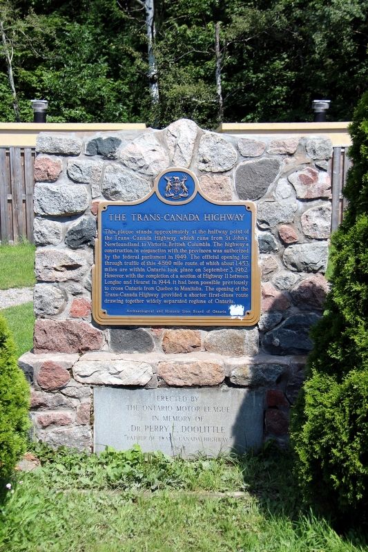
This plaque stands at approximately at the halfway point of the Trans-Canada Highway, which runs from St. John's, Newfoundland to Victoria, British Columbia. The highway's construction, in conjunction with the provinces, was authorized by the . . . — — Map (db m195918) HM
The original claim to the Bruce Mine location was filed in September, 1846 by James Cuthbertson. It was acquired the following year by the Montreal Mining Company, and production commenced in 1847-48 at what became the first commercially successful . . . — — Map (db m105635) HM
The ripple marks on the adjacent rock face were made some two billion years ago by waves in a shallow body of water. Buried by later deposition of silt and then subjected to great pressure, the rippled sand became sandstone. The formation was . . . — — Map (db m105638) HM
This building, built in 1912, was the terminal station and head office of the Algoma Central & Hudson Bay Railway Company. The A.C.R. was founded in 1899 by Francis Hector Clergue.
Re-dedicated on August 11, 1999 on the occasion of the company's . . . — — Map (db m198348) HM
Born in Dublin, Ireland, and raised in London, this famous 19th century author, illustrator and social reformer joined her husband, Robert Jameson, Attorney General of Upper Canada, at Toronto in 1836. The following June, unescorted, Mrs. Jameson . . . — — Map (db m105960) HM
Here, on a portion of his former estate, is buried Col. Prince who emigrated from England in 1833 and settled at Sandwich, Upper Canada. As commanding officer of the Essex Militia, he stirred up a violent controversy by ordering the summary . . . — — Map (db m105739) HM
Dedicated at the official opening of Roberta Bondar Park In honour of our hero, Dr. Roberta Lynn Bondar, O.C., O.ONT., M.D., PH.D., F.R.C.P.(C), neurologist, biologist, pilot and researcher. Canada's first female astronaut was a crew member on the . . . — — Map (db m106415) HM
[English] The Emergency Swing Bridge Dam was built by the Dominion Bridge company of Montreal in 1896. The dam was modeled on the American Sault Canal dam, but the Canadian design was modified and the structure built entirely of steel. . . . — — Map (db m198477) HM
This house, built between 1814 and 1823 by Charles Ermatinger of the North West Company, is the oldest surviving house in northwestern Ontario. Constructed when Sault Ste. Marie was still a small fur trading post on the Upper Lakes, this fine house . . . — — Map (db m105955) HM
A Maine-born promoter, Clergue transformed Sault Ste. Marie into a major industrial centre. He purchased an unfinished hydroelectric station and canal at the Sault in 1894; then, lacking markets for his electric power, he created his own . . . — — Map (db m106374) HM
Explorer, interpreter, fur trader and diplomat, French-born Perrot played an important role in the establishment and protection of New France's western frontier during the last four decades of the 17th century. In 1671 he was with Saint-Lusson at . . . — — Map (db m105957) HM
Until the mid-20th century, passenger and packet freighters were the most efficient means for transporting goods and people to and from isolated communities of the Upper Great Lakes. Essential to early regional development and instrumental in the . . . — — Map (db m105959) HM
This church was constructed in 1875 and dedicated in 1876 as the Parish Church of The Sacred Heart by Bishop Jean-Francois Jamot. It replaced a wooden building constructed in 1846 which had served as a Jesuit missionary post for this region. Built . . . — — Map (db m105953) HM
Completed in 1895, this canal formed the last link in an all-Canadian navigation system stretching from the St. Lawrence River to Lake Superior. Designed and built by Canadians, the canal incorporated several engineering innovations. It was the . . . — — Map (db m106185) HM
Shingwauk Hall was erected in 1935 to house a residential training school established in 1873 by the Reverend Edward F. Wilson. Under this Anglican missionary's tutelage the institution, named after the well-known Ojibway Chief Augustin Shingwauk . . . — — Map (db m105738) HM
In May, 1870, Col. Garnet Wolseley arrived here with an expeditionary force of British regulars and Canadian militia aboard the steamer "Chicora". They were travelling to Fort Garry on the Red River to put down an uprising led by Louis Riel. The . . . — — Map (db m106362) HM
The French explorers who first reached this favoured Ojibway hunting and fishing ground were soon followed by fur traders and missionaries who built a post and mission. By 1762 the region had come under British control and the trade eventually fell . . . — — Map (db m106412) HM
[English] You are standing beside the world's last Emergency Swing Dam. Only nine of these structures were ever built. Only this one was put to the ultimate test under emergency conditions.
In a 1909 emergency, this dam was swung across . . . — — Map (db m198462) HM
Travellers on the canoe route to the West had to make a portage around the St. Mary's rapids. The North West Company established a fur-trading post south of the river by 1791. After the British abandoned their occupation of the American midwest, . . . — — Map (db m106373) HM
[English] On June 9th, 1909, the Emergency Swing Dam was called into action! On this day, the freighter Perry G. Walker crashed into the lock gates causing a rush of water from Lake Superior to flood into the canal. The force of the water was . . . — — Map (db m198469) HM
[English] This steel structure looks like a bridge, but it is actually a dam. It is called the Emergency Swing Dam, since it was designed to swing out over the canal in an emergency and greatly slow the flow of water.
Only nine emergency . . . — — Map (db m198472) HM
Some 25 miles southwest of here lies the Detour Passage between Drummond Island and Michigan's upper peninsula. In August, 1814, it was occupied by the armed U.S. schooners "Tigress" and "Scorpion", whose intention it was to prevent supplies . . . — — Map (db m86040) HM
In recognition And In Tribute To The Men and Women Of The Mining Industry Who Developed The Gold Mines, And Our Community To What It Is Today. — — Map (db m218198) HM
Wawa's first town historian was Mrs. Agnes Turcott. Born Agnes Lindgren in Goren, Missouri in 1909, she spent her youth on the family homestead at Biggar, Saskatchewan. At the age of 18 she was a pioneer teacher earning $400 a year. Her marriage . . . — — Map (db m218197) HM
Born in Sault Ste. Marie, Ontario in August, 1907, Joseph Ernest Aime Breton was raised in a large family whose parents were involved in the hotel industry. Aime loved the wilderness and people. He could run a hotel just as easily as he could trap, . . . — — Map (db m218502) HM
Born in Cape Breton, Nova Scotia, Alex Ross was attracted to the Michipicoten area with hundreds of other fortune seekers after the cry of gold echoed through the hills in 1897. Alex first worked as a cook at the Minto Mine in 1898. Never one to . . . — — Map (db m218193) HM
Born in Sault Ste. Marie in 1929, Atillio (Tillio) was the oldest of 8 children of Reno and Pauline Berdusco. The family first settled at the Parkhill Mine where Reno worked as a gold miner and Pauline operated a dry goods store. When the gold . . . — — Map (db m218298) HM
Born in 1907, Al Turcott came to Wawa in 1939 with the idea that he would be employed for 6 months assisting with the construction of the crushing plant at the New Helen Mine. Deeply attracted to the area, Al soon sent for his wife Agnes and two . . . — — Map (db m218196) HM
It was erected to commemorate the completion of the last link of the Trans-Canada Highway. A Wawa Goose Statue has stood at the intersection of Highways 17 and 101 since September 1960.
The Idea
An innovation of long tíme Wawa resident B.A. . . . — — Map (db m195914) HM
[English] This highway's construction from St. John's to Victoria between 1949 and 1970 was a great feat of engineering, linking the provinces of this vast country. Here, in 1960, near the halfway point of the 7,821 kilometre-long . . . — — Map (db m199454) HM
Francis Hector Clergue was the visionary who recognized that Wawa's resource rich wilderness was the fuel to feed an industrial empire in Sault Ste. Marie. Born in Brewer, Maine in 1856, Clergue was a dynamic man with boundless energy, . . . — — Map (db m218375) HM
[east side] Glenn Gould is the iconic Canadian and internationally renowned piano virtuoso who revolutionized the way the world listens to the classics. Born in Toronto in 1932, Gould had perfect pitch at age 3, and appeared with the Toronto . . . — — Map (db m218599) HM
During the winter months mail was handled by dog sled. The "Hudson's Bay Trail" from Sault Ste. Marie to Michipicoten followed a well-worn path to Batchawana, skirted the shore at Mamainse Harbour, travelled overland to Agawa, then headed north in . . . — — Map (db m218602) HM
Joe Ball is one of Wawa's more colourful pioneers. Born in Michigan in 1864, Joe was one of many prospectors who found himself attracted to the lure of gold in the rugged hills around Wawa at the end of the 19th century. Joe worked as a caretaker . . . — — Map (db m218192) HM
Born in Saginaw, Michigan in 1920, Keith earned his private pilot’s license at the age of 20. He joined the U.S. Navy during World War II and was first stationed in Alaska. He flew OS2U Kingfishers and learned the hard way what the brutal Northern . . . — — Map (db m218191) HM
Lady Dunn was born Marcia Anastasia Christoforides in Sutton, England in 1909. During the Second World War, Marcia became the personal secretary for Sir James Dunn, a wealthy Canadian financier who was responsible for the rebirth and development of . . . — — Map (db m218190) HM
Louise Towab and her husband William Teddy are memorialized in Wawa's history books as discovering gold on Wawa Lake and forever changing the rugged landscape of this corner of Lake Superior country. Born in 1857, Louise represents the virtually . . . — — Map (db m218194) HM
The Michipicoten Ojibway have a long history on the eastern shore of Lake Superior and Wawa area. Michipicoten is an Ojibway word which some say translates to "landing place" or "place of large hills". At the time of first contact with European . . . — — Map (db m218179) HM
Mention Northern Ontario diamonds, log cabins or the Wawa Goose and the name Mickey Clement will quickly follow. Clifford Claude "Mickey" Clement was born with the prospecting bug. He learned the rules and tools of the trade while panning and . . . — — Map (db m218299) HM
Mountains of Minerals The town of Wawa is surrounded by some of the world's oldest rock. These ancient Precambrian mountains were formed some 2.7 billion years ago. Within these mountains is a melting pot of minerals that have . . . — — Map (db m218199) HM
The Joy Super Heavyweight Champion Rotary Blast Hole Drill was utilized by Algoma Ore Division first at the Sir James Open Pit Mine which operated from 1958-1967 and later at the Lucy Open Pit Operation from 1967 to 1970. More than 8,500,000 gross . . . — — Map (db m218300) HM
You are standing at the site of the completion of the last link of the Lake Superior section of the Trans-Canada Highway. It was officially opened for traffic on September 17, 1960. A Town Without a Road Out Prior to 1960 and the . . . — — Map (db m218201) HM
I think you would agree that the Wawa town site is situated in the perfect spot — a level plain on the shores of a picturesque lake of crystal green water surrounded by rolling mountains of natural abundance. Wawa's Ojibway ancestors, early . . . — — Map (db m218362) HM
Born in Chalut, France in 1813, Père Dominic Chardon du Ranquet became an ordained Deacon in 1838. He joined the Jesuit priesthood like his three older brothers before him. Instead of following them on their missionary work to India, he volunteered . . . — — Map (db m218601) HM
Rod Morrison Sr. and the Algoma Ore Athey Wagon go hand in hand. Roderick F. Morrison was born in the Muskokas in 1917. He followed his brother Neil to work in the gold mines of Matechewan in 1936. In 1940 the newly constructed Sinter . . . — — Map (db m218399) HM
This site is dedicated to the members of the Rotary Club of Wawa who helped to develop, maintain and preserve the scenic beauty of Magpie High Falls for all to see and enjoy. 1963-1989 In 1989 this area was expanded into a permanent recreational . . . — — Map (db m218665) HM
Sir James Dunn was a major Canadian business icon who was instrumental in the rebirth and growth of Wawa and Sault Ste. Marie in the first half of the 20th century. James Hamet Dunn was born in Bathhurst, New Brunswick in 1874. He was an articulate . . . — — Map (db m218195) HM
The famous Wawa Goose gazes out over the Trans-Canada Highway as it carries traffic through the Magpie River Valley. Some sections of this roadway follow old native trails and wagon paths leading from Lake Superior, along the Magpie River to the . . . — — Map (db m218328) HM
The nearby Michipicoten River formed an important link in the canoe route from Lake Superior to James Bay via the Michipicoten, Missinaibi and Moose Rivers. The route was probably explored at an early date by the French Fur traders who maintained a . . . — — Map (db m199496) HM
For Wawa residents, the name Surluga instantly conjures images of an overgrown gravel road, abandoned headframes rusted mining equipment and forgotten ghost towns. Tom Surluga was born in Krizisce, Croatia in 1907. As a teenager he found himself . . . — — Map (db m218397) HM
Wawa is just one of those place names that stands out. It is one of those names you will never forget. Where did this town get such a unique name and what does it mean? Ojibway Country When the first Europeans traveled to the Wawa . . . — — Map (db m218200) HM
Wawa's Forest Fire Rangers — A massive forest fire in 1920 destroyed many of the buildings in Wawa City which were located further from the Lakeshore. In 1930 the Department of Lands and Forests established a Deputy Chief Ranger office on Wawa . . . — — Map (db m218582) HM
Gold and Iron! What more could a mining town possibly want? The cry of "GOLD" in 1897 transformed the quiet fur trading country of Michipicoten into a bustling miniature Klondike. The Michipicoten Ojibway couple of Louise Towab and William Teddy . . . — — Map (db m218400) HM
Wawa's economy is based on our abundance of natural resources. Fur, fish, iron, gold, water and trees. The jumble of logs found at the base of Scenic High Falls are the remnants of Wawa's important logging history. Wood was first harvested along . . . — — Map (db m218600) HM
William Teddy was an Ojibway/Cree native Canadian born in 1855 in the Missinabie/Moose River region of Northern Ontario. Records show that William worked as a native guide for tourists, recreational fishermen and prospectors travelling thru the . . . — — Map (db m218189) HM
In memory of all who fell in honour of all who served in Freedom’s Cause 1914-1918 1939-1945 ”At the going down of the sun, and in the morning we will remember them.” — — Map (db m218401) WM
Born in Montreal in 1882 A.Y. Jackson took to painting at a young age. During his formative years, his passion took him to the streets of Chicago and the battlefields of Europe during World War I. His true attraction however was to the remote . . . — — Map (db m218291) HM
The weekly arrival of Captain Batten and the S.S. Caribou at Government Dock Beach at the mouth of the Michipicoten River was the highlight of early residents during the shipping season. Launched from her home port of Owen Sound in July 1904, the . . . — — Map (db m218556) HM
This beach received men & supplies for construction of the Canadian Pacific Railway in the 1880’s. In 1910 the Dominion Government & C.P.R. built a wharf and warehouse which were destroyed in the 1960’s. — — Map (db m218487) HM
The life and legacy of Louisa MacKenzie represents the important role of women in Canada's early frontier and the evolution of the fur trade industry. Louisa was the daughter of Honourable Roderick Mackenzie and a Chipewyan woman. Louisa was born . . . — — Map (db m218188) HM
Once the main cemetery used by residents of Michipicoten River Village. It includes families of both Ojibway and European descent. The earliest headstone dates back to 1901. — — Map (db m218482) HM
From this high bluff, on a clear northern day, you can see the vast expanse of Lake Superior and the dramatic coastline of Michipicoten Bay. This is one of the only accessible lookouts with a fantastic view of pristine Lake Superior, mysterious . . . — — Map (db m218668) HM
Born in Toronto in 1903, Morley Callaghan was a critically acclaimed writer and novelist. Recipient of the Governor Generals Award for his literary masterpieces, Morley Callaghan was a celebrated Canadian author who was commonly categorized with . . . — — Map (db m218488) HM
Michipicoten can be found on some of the earliest European maps created by early explorers of North America. One of the first official cartographers to put Michipicoten on the map was the English surveyor Philip Turnor. Born in the English . . . — — Map (db m218634) HM
Born in Fribourg, Switzerland in 1807, Jean Louis Rodolphe Agassiz was a renowned scientist who studied medicine, philosophy, fossils, fish, rocks, plants and glaciers. During the height of his career, Professor Agassiz was one of the best known . . . — — Map (db m218293) HM
Reverend James Evans was a Methodist missionary credited with translating the Cree language and creating the first Ojibway-Cree alphabet. Reverend Evans spent the winter of 1838-1839 at Michipicoten Post. Born in England in 1801, Evans emigrated . . . — — Map (db m218646) HM
Welcome to the centre of Canada's dynamic fur trade history for nearly 200 years. The Michipicoten First Nation's introduced the first European explorers to the rich fur-bearing forests of their home in the 1600's. Michipicoten was the ideal . . . — — Map (db m218187) HM
Unveiled by Her Excellency
The Lady Tweedsmuir
October 2, 1937
“For Home and Country"
To commemorate the birth place of
Adelaide Hunter-Hoodless
1858-1910
Who founded the Women's Institute
Feb. 19th 1897
Erected by . . . — — Map (db m232132) HM
Born in Paris, Ontario in 1915, Charles Joseph Sylvanus "Syl" Apps was a professional hockey player, businessman and politician. Throughout his life, Apps displayed remarkable breadth in his abilities and accomplishments. He was a varsity . . . — — Map (db m223241) HM
Ontario's thirteenth prime minister was born on this farm
and in 1913 graduated from Ontario Agricultural College.
A supporter of the United Farmers of Ontario, he was
elected to the provincial legislature in 1919 as member
for Brant North . . . — — Map (db m223085) HM
This house was built in 1831 by Hiram Capron, a
native of Vermont who, in 1822, had emigrated to Norfolk
County where he helped to establish one of Upper Canada's
earliest iron foundries. He settled here at the Forks of the Grand in 1829, . . . — — Map (db m223280) HM
Built by the free labour of its own congregation with
stones gathered from nearby fields, the West Dumfries
Chapel was completed and dedicated in 1845. It is a fine
example of a type of cobblestone construction seldom
found elsewhere in . . . — — Map (db m221681) HM
This house and the adjoining structure were built by Asa
Wolverton, a native of Cayuga County, New York, who had
immigrated to Upper Canada in 1826. About 1832 he settled
in Paris, where he erected sawmills and became a prosperous lumber . . . — — Map (db m223265) HM
On this site
Alexander Graham Bell
inventor of the telephone,
received from Brantford, Ontario,
on August 10, 1876,
the world's first successful
long distance telephone call.
Erected by the
Charles Fleetford Sise Chapter . . . — — Map (db m223183) HM
This Monument the work of Walter S. Allward, R.C.A. Sculptor, was placed here through International subscription by the Bell Telephone Memorial Association to mark the invention of the Telephone at Brantford by Alexander Graham Bell in 1874 — . . . — — Map (db m215700) HM
Architect John Turner and contractor William Sinon built this court house for the Provisional County of Brant in 1852-53. Turner was Brantford's most influential nineteenth-century architect, designing several important public buildings in Brant . . . — — Map (db m198273) HM
In July, 1852, the Six Nations Indians sold to Brant County the land upon which this court-house now stands. Designed by John Turner and William Sinon and erected by the Provisional County of Brant, the stone and brick building was largely . . . — — Map (db m198271) HM
In 1877 this house, then located in downtown Brantford,
became Canada's first telephone business office. It was
the residence of the Reverend Thomas Philip Henderson
(1816-1887), a former Baptist minister and school
inspector in Paris, . . . — — Map (db m230401) HM
Lingering Snow, oil on canvas, n.d. Collection of Glenhyrst Art Gallery of Brant George Thomson was born in Claremont, Ontario in 1868 and, at the age of nine, moved to Rose Hill Farm outside Leith, near Owen Sound. He is the oldest . . . — — Map (db m222039) HM
English: Originally called St. Paul's, this chapel was the first Protestant church in Upper Canada and is now the oldest surviving church in Ontario. Built by the Crown in 1785, it was given to those Mohawk Indians led by Joseph Brant who . . . — — Map (db m83743) HM
A Grand Legacy
In 1994, the Grand River was formally designated a Canadian Heritage River.
This honour recognizes rivers of outstanding significance and their important role in Canadian history. The Grand is unique, as it is the only . . . — — Map (db m240760) HM
Across the Grand River at this point lies "Bow Park", once the farm of George Brown, a leading architect of Confederation, who built up an estate of some 800 acres beginning in 1866. A Scottish immigrant, Brown founded the Toronto "Globe" in 1844, . . . — — Map (db m215793) HM
Log Cabin, oil on canvas, n.d. Collection of the City of Brantford John Claude Whale is the second son of painter Robert R. Whale and was born during his parents' voyage from England to Canada. A self-taught artist like his father, he . . . — — Map (db m243605) HM
Marsh Birds, oil on canvas, 1878 Collection of Glenhyrst Art Gallery of Brant John Hicks Whale was born in Liskeard, England in 1829 and is the nephew of artist Robert R. Whale. He emigrated to Canada in the early 1850s and married . . . — — Map (db m243674) HM
Born into a prominent Brantford family, Lawren Harris began to paint as a child. At the University of Toronto, a professor noticed he sketched during lectures and advised he be sent to Europe to study art. While in Germany (1904-1907), . . . — — Map (db m239617) HM
Three Chords, lithograph print, 1973 Collection of Glenhyrst Art Gallery of Brant Michael Snow is among the world's most celebrated artists and filmmakers. Born in Toronto in 1928, Snow's artwork and films have been exhibited at art . . . — — Map (db m221940) HM
English: Allies of the British during the American War of Independence, the Six Nations Iroquois received extensive lands along the Grand River in 1784. Mohawks, led by Joseph Brant, established a village of some 400 individuals here by . . . — — Map (db m83697) HM
Designed by John Turner and built in 1883, Park Baptist Church served as a place of worship for over a century until a dwindling membership led to closure in 1992. The fate of the building remained uncertain until 2000 at which time restoration . . . — — Map (db m215890) HM
[English]To commemorate our heroic Polish and Canadian soldiers under British Command in World War II To honor war veterans who fought for world freedom and all the people that endured suffering and hardship[Polski]Pamieci bohaterów . . . — — Map (db m243591) WM
This house, "Echo Villa", was built by the Reverend Peter
Jones (Kahkewaquonaby) who lived here from 1851 until
his death. Son of the noted surveyor, Augustus Jones, and
Tuhbenahneequay, a Missisauga chief's daughter, Peter was
born at . . . — — Map (db m237708) HM
Royal Victoria Place, originally known as the Commercial Buildings, was designed by John Turner and built in 1881 by Bernhard Heyd. One of the first occupants was the Royal Loan and Savings Company. Following a devastating fire in 1988, . . . — — Map (db m215851) HM
[English] Pioneering journalist in the late 19th century, Sara Jeannette Duncan challenged social and political norms by examining women’s changing roles, the need for a national culture, and the way Canadian politics . . . — — Map (db m215697) HM
[English] An internationally renowned author, Duncan was raised in the adjacent house and educated locally. She taught school briefly, but then determinedly turned to journalism, gaining notice for her distinctive and witty writing . . . — — Map (db m215698) HM
English:
This chapel, the first Protestant church in Ontario, was built by the Crown for the Mohawks of the Six Nations Iroquois who settled here in 1794. It replaced the Queen Anne Chapel (1712) at Fort Hunter, New York, which the Mohawk . . . — — Map (db m83694) HM
This National Monument erected by the Brant Memorial Association, Incorporated 41 Vic. Cap. 62 S.O. to Thayendanegea. Capt. Joseph Brant born 1742 died 1807 interred at Mohawk Church and to The Six Nations Indians for their . . . — — Map (db m215797) HM
The Bell Homestead
Here at his parents' home in July 1874, Alexander Graham
Bell conceived the fundamental idea of the telephone and, in August 1876, carried out the first successful long-distance trials. The Homestead evokes the . . . — — Map (db m230331) HM
2053 entries matched your criteria. The first 100 are listed above. Next 100 ⊳