On County Highway 2602 at County Highway 2601, on the left when traveling north on County Highway 2602.
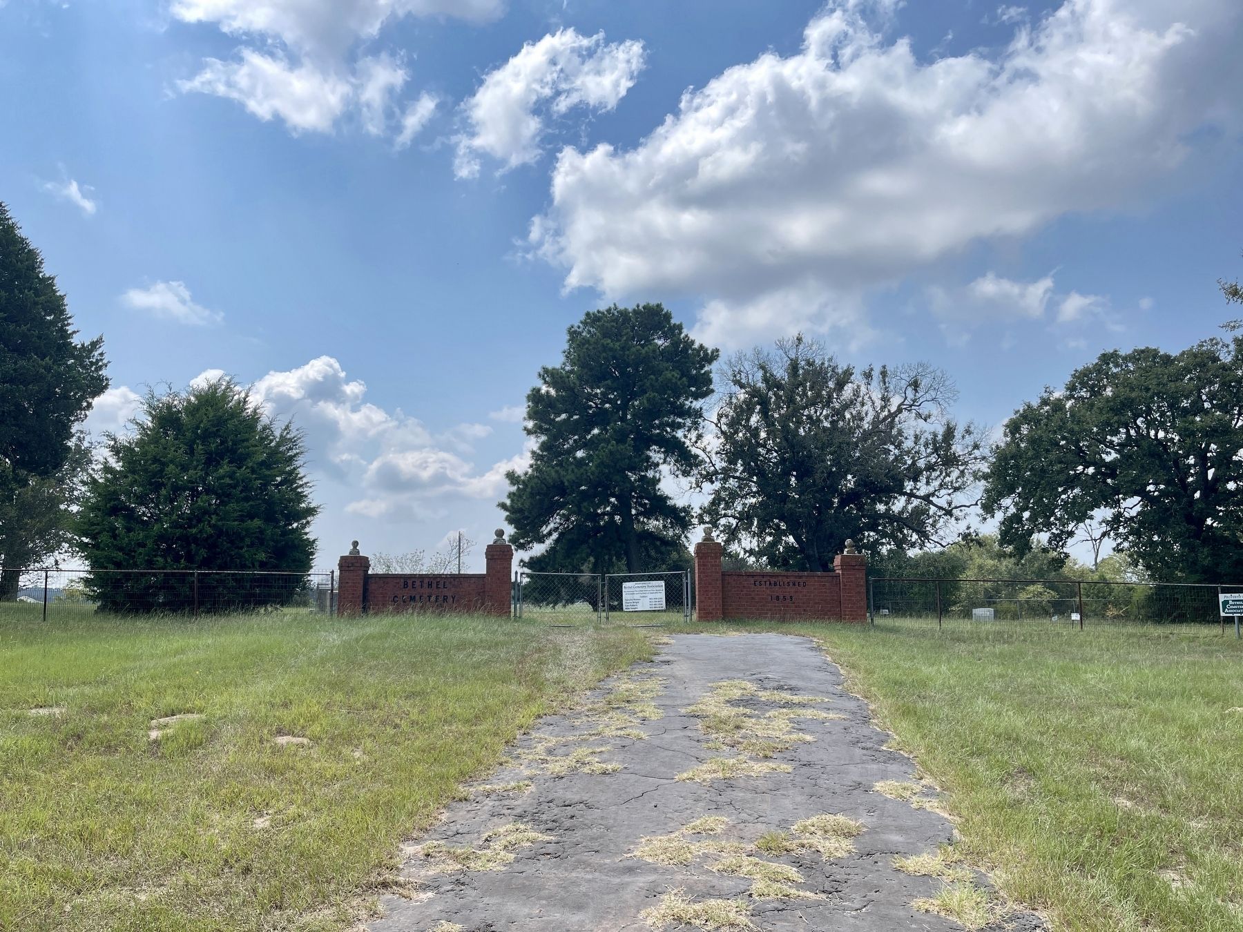
Originally part of a Mexican land grant awarded to Jose de Jesus Grande in 1828, land at this site was later granted to early area settler Henry Rampy. Rampy, who had come to this part of Texas in 1848, deeded 5 acres of his land in 1859 for a . . . — — Map (db m181660) HM
On West Parker Street (State Highway 294) 0.2 miles west of Hemby Street.
After the Civil War, the Cromwell family moved to Elkhart in Anderson County. Finding no organized Baptist church in the community, J.W. Cromwell decided to organize a Baptist church. In April of 1886, Cromwell and six other charter members founded . . . — — Map (db m207084) HM
On East Parker Street (State Highway 294) at Church Street, on the left when traveling west on East Parker Street.
The first Methodist service held in this area was in 1840. When a group of citizens formed a small congregation that met in private homes. In 1878 a Methodist mission was established in Elkhart. The Rev. J.F. Henderson, a circuit riding minister, . . . — — Map (db m207066) HM
On State Highway 294 at Farm to Market Road 319, on the right when traveling east on State Highway 294.
Organized in Illinois in 1833
by Daniel Parker
Members moved to Texas
First meeting in
Stephen F. Austin's Colony
January 20, 1834
Log church built December, 1839
Old graveyard adjoins.
Present church fourth on the same site . . . — — Map (db m36924) HM
On West Parker Street (State Highway 294) 0.1 miles west of Davis Street, on the right when traveling west.
Despite adverse conditions, African Americans in Texas in the late 19th century worked hard to provide their children with an education. Students in this area attended Mt. Moriah, Boxes Creek, Beulah, Washington Chapel, Union Hope and New Mt. Zion . . . — — Map (db m212161) HM
Near West Main Street at South Elm Street (State Highway 155).
In 1900 the Texas & New Orleans Railroad built a line through this area and plotted a townsite here on land owned by Frankie Miller. The town was named for "Miss Frankie" who donated this site, known as the Town Square, for a city park. By 1908 a . . . — — Map (db m161088) HM
On South Elm Street (State Highway 155) at South Miller Street, on the right when traveling south on South Elm Street.
In 1900 the Texas & New Orleans Railroad, now part of the Southern Pacific line, platted the town of Frankston. The station was first called Frankport and the post office Ayres. Both were renamed Frankston in 1902 for Miss Frankie Miller, who gave . . . — — Map (db m102007) HM
On County Highway 436 at County Highway 435, on the left when traveling south on County Highway 436.
Early denominational records indicate that this congregation was in existence as a mission church as early as 1880. In 1896, A.L. and Susanna Herrington donated one acre to the county to be used for a free school. A one-room school building was . . . — — Map (db m161100) HM
On Farm to Market Road 19 at Road 320, on the right when traveling south on Road 19.
Here General Thomas J. Rusk with 200 Texans on October 16, 1838, attacked a band of hostile Indians and allied Mexicans, molestors of frontier settlements, and routed them. — — Map (db m102008) HM
On Highway 19, 3.5 miles Highway 321, on the left when traveling north.
In area known as Beaver Valley, settled about 1853 -- the year that pioneer P. G. Oldham built his home a half-mile northwest of this marker. This was on the Palestine-Athens Road, the route taken by mail hacks in early days. To the east was a . . . — — Map (db m155482) HM
Near Cemetery Road (County Highway 4440) 0.2 miles south of State Highway 155.
The earliest marked graves in this cemetery date to the late 1850s. Although settlement of the Mound Prairie community occurred much earlier. Mound Prairie, once the home of a Baptist College known as Mound Prairie Institute, declined during the . . . — — Map (db m161101) HM
On Farm to Market Road 2574 at Neches Street, on the left when traveling north on Road 2574.
Murdoch McDonald was born in North Carolina on February 15, 1810, the son of Scottish immigrants. About 1832 he went to Georgia, where he met Dr. George Lester. In 1839, McDonald, along with Lester and his family, came to Texas. Settling in the . . . — — Map (db m136105) HM
On Loop State Highway 256 at Moody Street, on the left when traveling south on State Highway 256.
Alonzo Marion Story (1882-1966) was born in New Orleans to parents John and Mary Story. He attended public schools and graduated from Louisiana's Leland College before doing post-graduate work in Texas and Colorado.
Story came to Texas at the . . . — — Map (db m232792) HM
On North Mallard Street (State Highway 19) at East Poplar Street, on the right when traveling south on North Mallard Street.
Created March 24, 1846,
from Houston County
Organized July 13, 1846 with
Palestine as the county seat
Named in honor of
Kenneth Lewis Anderson
Vice-President of the
Republic of Texas
1844-45 — — Map (db m128942) HM
On North Church Street (State Highway 19), on the right when traveling north.
Created by the Texas Legislature on March 24, 1846, Anderson County was named for former Republic of Texas Vice President Kenneth L. Anderson. The first court in the new county was held in a log house at nearby Fort Houston in 1846.
The first . . . — — Map (db m128934) HM
On North Jackson Street at West Oak Street, on the left when traveling north on North Jackson Street.
After the creation of Anderson County in 1846, most settlers came from southern states, shaping the county’s destiny in the Civil War. When Texas became the seventh state to secede from the Union on March 2, 1861, the county vote, 870 to 15, was . . . — — Map (db m182382) HM
On East Murchison Street at East Calhoun Street, on the right when traveling west on East Murchison Street.
According to local tradition this congregation traces its origin to informal services held in various homes in Palestine as early as 1856. Although referred to as "Antioch Under the Hill" the congregation was formally named Antioch Baptist Church in . . . — — Map (db m219435) HM
On West Spring Street near North Howard Street, on the right when traveling west.
Born in Palestine on April 22, 1946, Steven Logan Bennett grew up in Lafayette, Louisiana. He graduated from Youngsville High School in 1964 and then enrolled at Southwestern Louisiana State (now the University of Louisiana at Lafayette) where he . . . — — Map (db m219475) HM
On West Spring Street at West Oak Street, on the right when traveling west on West Spring Street.
Born in Palestine in June 1850, Christopher Columbus Rogers was a noted and controversial lawman. Although his family moved to a rural area, Rogers returned to Palestine and lived with his sister, Eliza, and her husband, James Ewing. Rogers was 13 . . . — — Map (db m219281) HM
On North Mallard Street (State Highway 19), on the right when traveling south.
Born in Kickapoo (Anderson Co.) in 1901, Homer Garrison was the son of Mattie (Milam) and Homer Garrison, Sr. The family moved to Angelina County, where Homer, Sr. served as District Clerk. Homer, Jr. graduated from Lufkin High School and worked for . . . — — Map (db m128944) HM
On East Crawford Street at North Cedar Street, on the right when traveling west on East Crawford Street.
Donald Ray Hastings, born in 1936 in Palestine, was the son of William Benjamin and Grace (Jenkins) Hastings. He attended local schools and graduated from Palestine High School in 1954. The previous year, the local theater screened "The Iron . . . — — Map (db m232798) HM
On South Micheaux Street, on the right when traveling north.
Bonner Frizzell was born in the Pine Grove Community, near Athens, in 1882. He was the son of William Asachel and Frances Missouri (Knight) Frizzell. Bonner attended high school at Bruce Academy in Athens and then moved to Tyler to attend Tyler . . . — — Map (db m128978) HM
On Avenue A near East Oak Street, on the left when traveling west.
Organized Nov. 3, 1849, with 18 charter members, by the great pioneer leaders, Revs. Daniel Baker and John May Becton, home missionaries. This Gothic building of handmade brick was erected in 1888; enlarged since by two additions.Recorded . . . — — Map (db m219436) HM
On West Reagan Street at Knox Street, on the right when traveling east on West Reagan Street.
A fort and stockade built about 1836 on the public square of the town of Houston (then in Houston County), as a protection against the Indians, by order of General Sam Houston, Commander-in-Chief of the Texan Armies. The town was abandoned in 1846 . . . — — Map (db m182048) HM
On West Reagan Street at Knox Street, on the right when traveling east on West Reagan Street.
A stockade and blockhouse of the Republic of Texas. Built in 1835-1836 to protect settlers who founded Houston, a pioneer town, now in Anderson County.
Friendly Indians would come to trade at the site, but wary settlers often slept inside the . . . — — Map (db m182049) HM
On Harcrow Road, on the right when traveling south.
In 1835, Joseph Jordan and William S. McDonald donated about 500 acres of land in this area for the town of Houston, later known as Fort Houston. An early map of the townsite shows a section designated as a "public burying ground." The infant . . . — — Map (db m181890) HM
On North Church Street (State Highway 19) at East Lacy Street, on the right when traveling north on North Church Street.
Born near Rusk in Cherokee County, Thomas Mitchell Campbell was the son of Thomas Duncan and Rachel (Moore) Campbell. He financed his education by working for the County Clerk in Longview. In 1878 Campbell was admitted to the Bar and opened his law . . . — — Map (db m128941) HM
On East Hodges Street at North Church Street, on the right when traveling west on East Hodges Street.
In the 1870s, after the International & Great Northern Railroad line reached Palestine, brothers A. B. and Dan Hodges moved here from Tennessee Colony settlement and became leading merchants. This house was built in 1895 by Dan Hodges for his wife . . . — — Map (db m219437) HM
On East Park Avenue at Crockett Road (U.S. 287), on the right when traveling west on East Park Avenue.
John Henninger Reagan, son of Timothy and Elizabeth Lusk Reagan, was born on October 18, 1818, in Sevierville, Tennessee. He joined the Republic of Texas Army in 1839 and served in the Cherokee War. In the early 1840s, he held several public . . . — — Map (db m128981) HM
On North Jackson Street at West Oak Street, on the left when traveling north on North Jackson Street.
John Henninger Reagan, son of Timothy and Elizabeth Lusk Reagan, was born on October 18, 1818, in Sevierville, Tennessee. He joined the Republic of Texas Army in 1839 and served in the Cherokee War. In the early 1840s he held several public . . . — — Map (db m182822) HM
On East Park Avenue at Crocket Road (U.S. 287), on the right when traveling west on East Park Avenue.
(Front):John H. Reagan (Right):"The Old Roman's highest ambition was to do his full duty; consciousness of having done it was his ample reward." (Left):"A good name is rather to be chosen than great riches, and loving favor . . . — — Map (db m17496) HM
On West Oak Street near North Sycamore Street, on the left when traveling west.
Soren Kolstad (1823 - 1918), a skilled artisan and clockmaker, migrated to Texas from his native Norway in 1852. He settled in Palestine, where he opened a jewelry store in 1853. The store has occupied four locations. Mahogany display cases, . . . — — Map (db m182449) HM
On North Perry Street (Loop State Highway 127), on the right when traveling south.
Little is known about this Anderson County pioneer until he married Elizabeth Van Winkle in Crawford County, Illinois, in 1820. The Mains lived in the Illinois township of Palestine until 1833, when, drawn by a favorable change in the Mexican . . . — — Map (db m128935) HM
On East Calhoun Street at Head Street, on the left when traveling east on East Calhoun Street.
Freedmen organized this African Methodist Episcopal Church in 1873. The first sanctuary, a frame building at Mulberry and Birch Streets, was shared with a group of Missionary Baptists. In the late 1870s the Methodists built their own chapel at this . . . — — Map (db m232793) HM
On East Crawford Street at North Cedar Street, on the left when traveling west on East Crawford Street.
The crossroad of Crawford St. and the Wells Creek or Indian Creek has been a major part of Anderson County history.
1836 and earlier The Indians and settlers first traveled and traded along the creek making encampments and trading zones. . . . — — Map (db m232800) HM
On East Palestine Avenue (State Highway 19) at North Laura Street, on the right when traveling east on East Palestine Avenue.
Native American photographer, artist and writer Osjetea Briggs was born on December 14, 1917, to Simeon Singleton Briggs (1877-1974) and Docia Augusta (Gant) Briggs (1894-1969) in Groesbeck, Limestone County, Texas. Following her high school . . . — — Map (db m186131) HM
On Avenue A (State Highway 127) at North Elm Street, on the left when traveling east on Avenue A.
Palestine, founded 1846, acquired fire department when International & Great Northern Railroad extended line here in 1872. Early fire-wagon was horse-drawn flatbed loaded with hose. Motor truck and city water were introduced 1918. Bell from 1895 . . . — — Map (db m232794) HM
On South Micheaux Street, on the right when traveling north.
A public school system in Palestine was established in 1881 under control of the municipal government. The first classes were held at the old Palestine Female Institute (built in 1858), then a high school was built in 1888 at the Institute site on . . . — — Map (db m128980) HM
On North Church Street (State Highway 19) at East Crawford Street, on the right when traveling north on North Church Street.
(Front and southwest side): Located 6.5 miles southwest during the Civil War this salt works was assigned to produce salt for the Confederacy at a fixed price of eight dollars for a hundred-pound sack. Private customers from East Texas, . . . — — Map (db m31881) HM
On East Lacy Street, on the right when traveling east.
P.L. Chism’s devotion to education was unsurpassed. From the time of his youth, through his many years as a teacher, principal, superintendent and supervisor, he never stopped challenging himself and others for education. Purvey Lee Chism was born . . . — — Map (db m128938) HM
On South Micheaux Street, on the right when traveling north.
As a coach of athletics and a youth mentor, Robert (Bob) Knight positively influenced the lives of countless Palestine citizens. He was born in Iredell (Bosque County) in 1909, the last of eight children of William and Missouri Jane (Hand) Knight. . . . — — Map (db m128977) HM
On South Micheaux Street, on the right when traveling north.
Roy B. Wallace was born in Coolidge, Limestone County, on October 13, 1901, to Benjamin C. Wallace, Sr. And Mae McCoy Wallace. Roy attended school in rural Limestone County and attended Texas Christian University prior to earning his Bachelor’s . . . — — Map (db m128979) HM
On West Oak Street at North Queen Street, on the right when traveling west on West Oak Street.
Successor to 1874 Church of St. Joseph, built on site given by International & Great Northern Railway, and destroyed by fire in 1890. This building of handmade brick was begun later that year; Nicholas J. Clayton of Galveston was the . . . — — Map (db m219438) HM
On East Kolstad Street east of North Elm Street, on the left when traveling east.
Built in 1848 as the home of Judge John B. Mallard, first lawyer in Palestine. Became the home of Judge William Alexander in 1857. Alexander was Chief Justice of Anderson County 1860-1865, and a trustee of the first school in Palestine. . . . — — Map (db m185721) HM
On Avenue A at East Main Street, on the left when traveling west on Avenue A.
James B. McKnight moved to Anderson County in 1848. In 1876 and 1879, he bought land at this site from J.H. Mead. Here, he operated a saddlery and farrier business. McKnight died in 1907, and in 1910, the property was sold to the Farmers and . . . — — Map (db m232802) HM
On State Highway 294 at County Road 2117, on the right when traveling east on State Highway 294.
(one-half mi.S) Founded in 1840s as a ferrying point on the Caddo Trace; later became a major landing for flatboats and steamers on the Trinity River, where cotton and other products were shipped by a four-day trip to Galveston to be exchanged for . . . — — Map (db m232591) HM
On State Highway 294, 0.5 miles east of U.S. 79, on the right when traveling east.
Woodhouse School began with the consolidation of the Long Lake, Tucker and Magnolia schools into Consolidated Common School District No. 7. These were all small schools, each with two teachers: one for grades one through four and another for grades . . . — — Map (db m136004) HM
On Park Road 70, on the left when traveling south.
Micam Main of Illinois was granted a league of land by the Mexican government in 1835. One of the area's first brickmakers, Samuel M. Warden, died while working on Main's estate on Christmas Eve in 1847. He was interred on this site. According to . . . — — Map (db m128982) HM
On Park Road 70, on the left when traveling south.
The Texas Prison System built a short rail line from the Rusk State Penitentiary to hardwood timber stands where charcoal was made for firing the prison's iron ore furnaces. The rail line became the foundation of the Texas State Railway, organized . . . — — Map (db m128983) HM
On West Spring Street at West Oak Street, on the right when traveling west on West Spring Street.
Established as Anderson County seat in 1846 by the Texas Legislature, Palestine grew steadily throughout the remaining 19th century, nearing 9,000 residents by 1900. The town first centered on trade facilitated by the Trinity River, with . . . — — Map (db m155447) HM
On East Lacy Street, on the right when traveling east.
Born the son of a runaway slave, Smith yearned for a better life. He attended Prairie View A&M College and received a degree in Vocational Agriculture. He became a teacher, educating the children of North Carolina and Texas for 42 years. He also . . . — — Map (db m128939) HM
Near Moody Street east of Birch Street, on the right when traveling east.
William Freeman was born a slave in Anderson County on August 1, 1863, to Charlotte Freeman. His mother was a slave and the maid at the Jacob Hunter Plantation near Mound Prairie. After the slaves were freed in 1865, they moved to Palestine. . . . — — Map (db m186069) HM
On West Broadway Street at NW 6th Street, on the right when traveling west on West Broadway Street.
American Civil War
12 April 1861 - 9 April 1865
U.S. President Abraham Lincoln
The War Between the States began when 11 Southern states demanding stronger state rights seceded and formed the Confederate States of America led by . . . — — Map (db m164164) HM WM
On Eunice Highway (State Highway 176) at SW 3001, on the left when traveling west on Eunice Highway.
C.E. Ogden No. 1, producing 200 barrels a day from San Andres lime formation was brought in, Dec. 1929, by Deep Rock Oil Co.--The Andrews County discovery well and first of 730 wells in Fuhrman-Masco oil field.
Bought, Feb. 1932, by . . . — — Map (db m61380) HM
On West Broadway Street, on the right when traveling west.
Andrews County Veterans Memorial was dedicated on the 11th hour of the 11th day of the 11th month of 2006.
All veterans that are living or deceased that served in the military will be eligible. The veteran must be honorably discharged and born, . . . — — Map (db m110153) WM
On North Main Street (U.S. 385) at NE Avenue A, on the right when traveling south on North Main Street.
On May 25, 1965, from one of 7,400 producing oil wells in the county's 196 fields, came the Billionth Barrel of Andrews County crude oil.
In the 35 years and 5 months since oil flowed from the county's discovery well, C.E. Ogden No. 1, in Dec. . . . — — Map (db m61377) HM
On West Broadway Street, on the right when traveling west.
In recognition of loyal and unselfish service to the community of Andrews over a period of 47 years.
This building will henceforth be known as the C.E. Carruth Bi-Centennial Building
As a key member of the American Revolution Bi-centennial . . . — — Map (db m164031) HM WM
Descendant of a Virginian who fought in the American Revolution. Came to Texas at 17 for health. Served (1898-1899) in Spanish-American War, Co. K, 1st Texas Inf. Vol. Regt. Later took up ranching in Andrews County. Married Jessie Whitten; had 4 . . . — — Map (db m61373) HM
On West Broadway Street at NW 7th Street, on the right when traveling west on West Broadway Street.
One of last frontiers of Texas. Anglo settlement here lagged 60 years behind rest of state due to Indians and scarcity of water.
In 1886 O.B. Holt became first man to file for county land. First settlers included the Cowden brothers and Peter . . . — — Map (db m61375) HM
On West Broadway Street at NW 6th Street, on the right when traveling west on West Broadway Street.
"We will not waiver, we will not tire we will
not falter and we will not fail. Peace and freedom
will prevail. George W. Bush
Persian Gulf War
2 August 1990 - 11 April 1991
U.S. President George H. Bush
The occupation of Kuwait . . . — — Map (db m164078) HM WM
Near County Park Road, 1.3 miles east of U.S. 385, on the right when traveling east.
Named for old town of Florey, established as a post office 7 miles to the northeast in 1909, prior to the organization of Andrews County, June 1910.
In heart of the Means Oil Field, opened 1930, this park is at site of a 1934-1958 camp of . . . — — Map (db m61421) HM
On Eunice Highway (Route 176) at Farm to Market Road 181, on the right when traveling east on Eunice Highway.
In 1941 the Fullerton Oil Company of California struck oil near this site, and by 1945 more than 100 drilling rigs were in operation. The discovery brought great numbers of workers into the area, resulting in the establishment of the town of . . . — — Map (db m61418) HM
On West Broadway Street at NW 6th Street, on the right when traveling west on West Broadway Street.
"Events have brought our
American democracy to
new influence and new
responsibilities. They will
test our courage, our devotion to duty, and our
concept of liberty to that end. We will devote our
strength, our resources, and our firmness . . . — — Map (db m164053) HM WM
On NE 2nd Street at NE Avenue C, on the right when traveling south on NE 2nd Street.
Organized in 1907 by circuit preacher F.T . Pollard and seven charter members. The group held services in local school until 1912, when a one-room church was built, financed by donations of members, including a generous gift from rancher J.S. Means. . . . — — Map (db m61379) HM
On Farm to Market Road 1788, 0.5 miles north of State Highway 176, on the right when traveling north.
Chartered Jan. 16, 1916, by Midland Farms Co., which was owned by David Fasken of Toronto, Canada. The 65 miles of road were completed from Midland to Seminole in 1918. Operated with an engine borrowed from Texas and Pacific Railway until 1920, when . . . — — Map (db m110192) HM
On West Broadway Street at NW 7th Street, on the right when traveling west on West Broadway Street.
Founded when Andrews County was organized, in 1910, on land owned by Robert Madison Means (b. 1878). With his father, J.S. Means, "Bob" Means began homesteading here in 1899 and organized an abstract company in 1909. When Andrews battled Shafter . . . — — Map (db m61374) HM
On Shafter Lake Road (Farm to Market Road 1967) 2.3 miles west of NW 2001, on the right when traveling west.
First town in yet-unorganized Andrews County. Platted 1908.
Named for lake charted in 1875 survey of Col. Wm. R. Shafter, whose maps and victories over powerful Indians opened the Permian Basin to settlement.
Water trough built by John . . . — — Map (db m61420) HM
On Andrews Street at South Main Street (U.S. 385), on the right when traveling north on Andrews Street.
In 1875, Col. Wm. R. Shafter and a company of soldiers traveled from Fort Concho (where San Angelo is today) to Monument Springs, N. Mex., charting the arid plains, mapping all the vital watering places.
This marker is in the only town of . . . — — Map (db m61376) HM
On West Broadway Street (State Highway 176) at NW 7th Street, on the left when traveling east on West Broadway Street.
Built in 1900, this is one of the
oldest houses in Andrews County.
S. H. Purcell, his wife, and two
relatives each filed on a section
of public land, building this home
where section-corners met, so
that each individual could fulfill
the . . . — — Map (db m164030) HM
On North Main Street (U.S. 385) at NE Avenue A, on the right when traveling south on North Main Street.
Andrews County produced it’s 2nd billionth barrel of crude oil August 21, 1981. Sixteen years and 96 days after its first billionth barrel came from beneath the county’s 1500 square miles.
In producing two billion barrels in 52 years, Andrews . . . — — Map (db m61378) HM
On West Broadway Street, on the right when traveling west.
"Let every nation know,
whether it wishes us well
or ill, that we shall pay
any price bear any burden,
meet any hardship support
any friend to assure the
survival and success
of freedom."
John F. Kennedy
Vietnam War
5 August . . . — — Map (db m164076) HM WM
On West Broadway Street (State Highway 176) at NW 6th Street, on the right when traveling west on West Broadway Street.
A nation which does not
remember what it was
yesterday does not know
what it is today nor what
it is trying to do. We are
trying to do a futile thing.
If we do not know where we
came from or what we have
been about.
T. Woodrow Wilson
. . . — — Map (db m164034) HM WM
On West Broadway Street at NW 6th Street, on the right when traveling west on West Broadway Street.
"We must be the great
arsenal of democracy, it is the strength of men and women who value their
freedom more highly than they value their live. We have the men - the
skill the wealth - and
above all the will...
Franklin D. Roosevelt
World . . . — — Map (db m164074) HM WM
On U.S. 59 at Blue Jay Street, on the left when traveling north on U.S. 59.
Founded in 1889 by a small group of Methodists, this church has played an integral role in the history of the community. H. and Nannie Belote donated land to the congregation in 1894, and the first church building was completed in 1901. It was moved . . . — — Map (db m30331) HM
On Tidwell Road (County Road 62), on the left when traveling west.
The community of Burke was established along the Houston, East and West Texas Railroad in 1882. S.J. and Nancy Arrington conveyed one acre of land adjoining the town on which to establish a public school. The first building, a one-room structure, . . . — — Map (db m37848) HM
On Farm to Market Road 2108, on the left when traveling south.
The Angelina County School Board created Fairview Common School District Number 69 in the late 1800s. A one-room schoolhouse was built that served students from a wide rural area. The first school term, in 1898, was five months long.
Fairview . . . — — Map (db m79121) HM
This school traces its origin to five small schools in the Pollok-Central area; Union, Durant, Pollok, Clawson, and Allentown. An effort to solve the problem of inadequate funding for each of these rural schools led to their consolidation in 1929 as . . . — — Map (db m29237) HM
On County Road 843 south of U.S. 69, on the right when traveling south.
This burial ground, which contains over 3,000 graves, has served area residents since the mid-1800s. In 1860, Nathan W. Gann, who came to Texas with his family in 1836, donated this property and a church building he constructed to Williams Chapel . . . — — Map (db m28290) HM
On North Temple Drive (U.S. 59) near Kenley Street, on the right when traveling north.
A sawmill established here in 1894 by T.L.L. Temple gave rise to a town that by 1900 contained a commissary, post office, churches, homes, and schools run by the Southern Pine Lumber Company. The town was named for the Diboll family of New Orleans . . . — — Map (db m30360) HM
On Maynard Street at Booker Street, on the left when traveling west on Maynard Street.
Emporia Lumber Company co-owner S.F. Carter and M.T. Jones purchased over 5,000 acres of land in south Angelina County and established a company town named Emporia in 1893. The town included sawmill facilities, a railroad spur to ship lumber, . . . — — Map (db m37824) HM
On Hines Street, on the left when traveling south.
This congregation was founded about 1897, soon after Diboll was established as a sawmill town. Early worship services were held in a local schoolhouse and in a two-story structure shared with the local Baptist congregation and fraternal . . . — — Map (db m38057) HM
Built about 1908 by T.L.L. Temple for his Southern Pine Lumber Company employees, this building served for many years as a community library and recreation hall. While the lower floor included a reading room and recreational facilities, the upper . . . — — Map (db m38050) HM
On Prairie Grove Road (County Road 263) near Farm to Market Road 1818, on the left when traveling south.
The community of Prairie Grove began in 1845 and became a place for early settlers to gather. A cemetery began in 1849 when the young daughter of John M. and Caroline Stovall died. In the 1880s a school/church building was erected near the cemetery, . . . — — Map (db m79123) HM
On Farm to Market Road 2497 west of Farm to Market Road 304, on the left when traveling west.
Founded 1866, after new settler, Rev. Issac Ryan, had Methodist revival in home before occupying it. His brother John was one of 19 charter members. L.H.D. and Sallie Guinn gave 7.5 acres for church and cemetery. First 16 by 20-ft. church had . . . — — Map (db m37821) HM
On Park Street south of Weber / Farrington Street, on the left when traveling south.
Virginia native Thomas Lewis Latane Temple, son of Henry W.L. and Susan (Jones) Temple, moved to Texarkana, Texas, in 1877. He married Georgie D. Fowlkes in 1880. In 1893 Temple organized the Southern Pine Lumber Company in Texarkana and began . . . — — Map (db m30374) HM
On Main Street (Farm to Market Road 1669), on the left when traveling east.
Settlers attempted to form a townsite in this area in the 1890s, but it was not until the arrival of the railroad lines that it attracted a thriving population. Carved from virgin forests in the heyday of the southern pine timber industry and . . . — — Map (db m34882) HM
On Farm to Market Road 2109 near Farm to Market Road 2801, on the right when traveling south.
When Angelina County was organized in 1845, Alabama native Joseph Herrington (1823-89) was one of six men appointed by the legislature who set boundary lines and selected Marion as the first seat of government. That same year, at the age of 22, he . . . — — Map (db m32054) HM
On Ellis Avenue at Herndon Street, on the right when traveling west on Ellis Avenue.
The first notice found of the Daily Newspaper in Lufkin is
in the Feb. 14, 1907 Nacogdoches Sentinel: "Lufkin has an afternoon daily paper, The News. While a copy of the newspaper has never reached this office, it is said to be a . . . — — Map (db m221468) HM
On North Second Street at Howe Avenue on North Second Street.
In 1690, when Spain's Franciscan Fathers founded Mission San Francisco de los Tejas in East Texas, they found a young Indian girl living with her people beside a stream. The priests found her a willing ally for carrying the Catholic Faith to the . . . — — Map (db m27249) HM
On Spence Street, on the right when traveling south.
Chartered in August 1900 and headquartered in the sawmill town of Keltys, the Angelina and Neches River (A&NR) Railroad began as a small short line railroad to move logs from the woods of East Texas to the mills of the Angelina County Lumber . . . — — Map (db m29735) HM
On Charlton St. east of Third Street, on the right when traveling east.
Created and organized in 1846. Originally a part of Nacogdoches County. Bears the name of the river traversing the region. The following towns have served as the county seat; Marion,1846-1854; Jonesville,1854-1858; Homer, Feb. 3 - May 17, 1858, when . . . — — Map (db m29862) HM
On Farm to Market Road 842, on the left when traveling north.
In 1850, Samuel and Elizabeth Berry brought their family and slaves here from Limestone Co., Alabama. Samuel's plantation covered hundreds of acres and included a cotton gin and gristmill. Berry Cemetery began in 1863 when Samuel's grandson and . . . — — Map (db m36110) HM
On Ellis Street east of Kelley Street, on the left when traveling west.
Born here, in now-razed house, Oct. 5, 1907, to Robert and Easter C. Shivers, pioneer East Texas family. As youth, worked at odd jobs to earn own pocket money. Was State Senator 12 years; Lieutenant Governor for two. A strong, progressive . . . — — Map (db m202013) HM
On Cotton Square near Lufkin Avenue, on the right when traveling south.
City's hub, 1882-early 1900s, teeming with cotton buying, horse trades, band concerts, political rallies, switching railroad trains. Site of fire station, standpipe, 1933 memorial library named for lumberman J. H. Kurth (1857-1930), square was . . . — — Map (db m201867) HM
On John Redditt Drive (Loop Route 287), on the right when traveling north.
June 1, 1933 - February 10, 2010
United States Naval Officer and
12-Term United States Representative, 2nd District of Texas
A Sonnet to Charlie
Now before us in bronze, he once again stands tall:
Beloved Texan, who heard his . . . — — Map (db m39781) HM
On South Timberland Drive near Tulane Street, on the right when traveling north.
Founded 1882. Soon became a thriving sawmill community. Named for E.P. Lufkin, chief of crew that surveyed railroad through town. Has been county seat of Angelina County since 1892. Now a regional manufacturing and commerce center. Products include . . . — — Map (db m28715) HM
On U.S. 59, 0.4 miles north of Bates R, on the right when traveling north.
Responding to rumors of French trade activity in Spanish Texas, Don Joaquin de Orobio y Basterra, Captain of Presidio La Bahía, led soldiers on a reconnaissance mission in 1745-46. Encountering Nabedache, Bidai and Orcoquizac settlements, Orobio . . . — — Map (db m221071) HM
Near Atkinson Drive (State Highway 103) at Goleta Avenue.
One of last ox-drawn or mule-drawn carts skidding logs to railroad from the forests. Built 1950 for W. T. Carter & Brother, a lumber firm, and replaced 1951 by tractor-powered equipment, this slip-tongue, high wheel cart is a relic of early . . . — — Map (db m156870) HM
14428 entries matched your criteria. The first 100 are listed above. Next 100 ⊳