Capitol Hill in Southwest Washington in Washington, District of Columbia — The American Northeast (Mid-Atlantic)
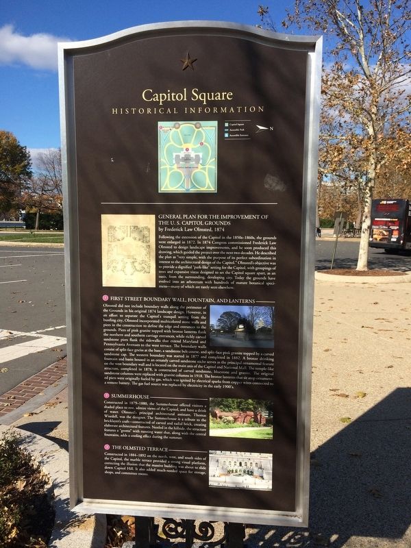
Capitol Square
Historical Information
General Plan for the Improvement of the U.S. Capitol Grounds
by Frederick Law Olmsted, 1874
Following the extension of the Capitol in the 1850s-1860s, the grounds were enlarged in 1872. In 1874 Congress commissioned Frederick Law Olmsted to design landscape improvements, and he soon produced this drawing, which guided the project over the next two decades. He described the plan as "very simple, with the purpose of its perfect subordination in interest to the architectural design of the Capitol." Olmsted's objective was to provide a dignified "park-like" setting for the Capitol, with groupings of trees and expansive vistas designed to set the Capitol square apart, as an oasis, from the surrounding, developing city. Today the grounds have evolved into an arboretum with hundreds of mature botanical specimens--many of which are rarely seen elsewhere.
1. First Street Boundary Wall, Fountain, and Lanterns
Olmsted did not include boundary walls along the perimeter of the Grounds in his original 1874 landscape design. However, in an effort to separate the Capitol's tranquil setting from the bustling city, Olmsted incorporated multicolored stone walls and piers in the construction to define the edge and entrances to the grounds. Piers of pink granite topped with bronze lanterns flank the northern and southern carriage entrances, while richly carved sandstone piers flank the sidewalks that extend Maryland and Pennsylvania Avenues to the west terrace. The boundary walls consist of split-face gneiss at the base, a sandstone belt course, and split-face pink granite topped by a carved sandstone cap. The western boundary was started in 1877 and completed in 1882. A bronze drinking fountain and basin house in an ornately carved sandstone niche serves as the principal ornamental feature on the west boundary wall and is located on the main axis of the Capitol and National Mall. The temple-like structure, completed in 1878, is constructed of carved sandstone, bluestone and granite. The original sandstone columns were replaced with granite columns in 1918. The bronze lanterns that sit atop the ornamented piers were originally fueled by gas, which was ignited by electrical sparks from copper wires connected to a remote battery. The gas fuel source was replaced by electricity in the early 1900's.
2. Summerhouse
Constructed in 1879-1880, the Summerhouse offered visitors a shaded place to rest, admire views of the Capitol, and have a drink of water. Olmsted's principal architectural assistant, Thomas Wisedell, was the designer. The Summerhouse is a tribute to the bricklayer's craft--constructed of carved and radial brick, creating elaborate architectural features. Nestled
3. The Olmsted Terrace
Constructed in 1884-1892 on the north, west, and south sides of the Capitol, the marble terrace provided a strong visual platform, correcting the illusion that the massive building was about to slide down Capitol Hill. It also added much-needed space for storage, shops, and committee rooms.
Topics. This historical marker is listed in this topic list: Architecture. A significant historical year for this entry is 1872.
Location. 38° 53.319′ N, 77° 0.717′ W. Marker is in Southwest Washington in Washington, District of Columbia. It is in Capitol Hill. Marker is at the intersection of 1st Street Southwest and Garfield Circle Southwest on 1st Street Southwest. Touch for map. Marker is at or near this postal address: 109 1st Street Southwest, Washington DC 20219, United States of America. Touch for directions.
Other nearby markers. At least 8 other markers are within walking distance of this marker. United States Botanic Garden (within shouting distance of this marker); Capitol Square, SW (within shouting distance of this marker); James A. Garfield (within shouting distance of this marker); Citrus (within shouting distance of this marker); Grains (within shouting distance of this marker); Medicinal Natives (within shouting distance of this marker); a different marker also named Capitol Square, SW (about 300 feet away, measured in a direct line); Onion Farm (about 500 feet away). Touch for a list and map of all markers in Southwest Washington.
Credits. This page was last revised on January 30, 2023. It was originally submitted on November 22, 2017, by Devry Becker Jones of Washington, District of Columbia. This page has been viewed 231 times since then and 15 times this year. Last updated on November 27, 2021, by Carl Gordon Moore Jr. of North East, Maryland. Photos: 1, 2. submitted on November 22, 2017, by Devry Becker Jones of Washington, District of Columbia.

