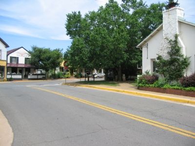
The Plains in Fauquier County, Virginia — The American South (Mid-Atlantic)
The Plains
The Death of a “Jessie Scout”
— Mosby’s Confederacy, First Manassas Campaign, Second Manassas Campaign —
The Plains, situated on the Manassas Gap Railroad between Piedmont Station and Manassas Junction, was frequently traversed by troops from both sides.
Throughout the war, local resident Edward (Ned) Carter Turner kept a detailed diary. Ned’s son, who died while in service, served with Mosby’s Rangers while Ned’s brother was a Rear Admiral in the U.S. Navy. On August 30, 1862, following the Battle of Second Manassas, Turner wrote: “The fighting portion of the army [Confederate Army of Northern Virginia] has passed, but the whole country is swarming with stragglers or deserters who are making themselves extremely troublesome to the people. Our yards are crowded with them all day and the bar and stable lofts at night. They are begging food of people who have none to give and are insolent and revengeful when disappointed.”
Two days before, on August 28, a Federal spy was hanged on an oak tree just east of here (on modern Route 55). Jack Sterry was caught by Confederate Gen. John Hood and judged a “Jessie Scout,” named for Jessie Fremont, wife of Union Gen. John Fremont, who suggested that Federal spies avoid detection by dressing in Confederate uniforms. Sterry was discovered when the soldier from whom he stole the uniform was found nearby, mortally wounded. The dying soldier identified his assailant, and the swift sentence was determined by a drum-head court. Nearly 75 years later, highway workers unearthed the remains of two soldiers, thought to be the spy and his victim, when widening Route 55.
Dr. Edward Clarke, a local physician, was a spy of a different sort. As Union troops passed his porch (now 6494 Main St.), he casually whittled a stick, carving a notch for each piece of artillery. A manservant took the notched stick to waiting Confederate officers.
[picture caption] "Crossing the Manassas Gap Railroad, and the Alexandria and Warrington (sic) Turnpike, at White Plains;" so reads the incorrect caption to an engraving in the September 28, 1861, edition of Harper’s Weekly. The mistake originated in the 1859 edition of the Nine-sheet Map of Virginia which misidentified The Plains as White Plains.
Erected by Civil War Trails.
Topics and series. This historical marker is listed in this topic list: War, US Civil. In addition, it is included in the Virginia Civil War Trails series list. A significant historical year for this entry is 1862.
Location. 38° 51.722′ N, 77° 46.451′ W. Marker is in The Plains, Virginia, in Fauquier County. Marker is at the intersection of Main Street/John Marshall Highway (Virginia Route 55) and Old Tavern Road/Fauquier
Ave (Virginia Route 245), on the right when traveling east on Main Street/John Marshall Highway. Touch for map. Marker is in this post office area: The Plains VA 20198, United States of America. Touch for directions.
Other nearby markers. At least 8 other markers are within 5 miles of this marker, measured as the crow flies. Campaign of Second Manassas (approx. 0.2 miles away); Number 18 School (approx. 3.1 miles away); Confederate Memorial (approx. 3.4 miles away); Heflin's Store (approx. 3˝ miles away); a different marker also named Campaign of Second Manassas (approx. 4.3 miles away); Thoroughfare Gap (approx. 4.3 miles away); a different marker also named Thoroughfare Gap (approx. 4.3 miles away); McClellan Relieved From Command (approx. 4.3 miles away).
More about this marker. Caption under main Picture: “Crossing the Manassas Gap Railroad, and Alexandria and Warrington (sic) Turnpike, at White Plains;” so reads the incorrect caption to an engraving in the September 28, 1861, edition of Harper’s Weekly. The mistake originated in the 1859 edition of the Nine-sheet Map of Virginia which misidentified The Plains as White Plains.
Presumably, Warrenton was intended where Warrington name was used.
The marker also features a small picture of John S. Mosby.
Regarding The Plains. The exact sites of the hanging of Jack Sterry
and where the bodies were exhumed 75 years later is not reported accurately in any source.
Additional commentary.
1. Place Name Confusion
As mentioned in the caption for the woodcutting on the marker, the name of The Plains was incorrectly marked on maps prior to the Civil War. The Plains should not be confused with White Plains, VA, in the Southern section of the Commonwealth. When reading official dispatches from the Civil War period, accounts use both names depending on the source.
— Submitted June 23, 2007, by Craig Swain of Leesburg, Virginia.
2. The Plains Name Confusion
I found Craig Swain's comments informative. I have been struggling with understanding the Confederate troop movements described in my great grandfather's diary of his time in the 13th Miss Infantry. Apparently he used the term "white plains" to describe a campsite used during the retreat from Leesburg. He also used the spelling "Warrington", I assume from Warrenton which he described as 12.5 miles from "The Plains". Curious that the Harper's print has the same two errors.
— Submitted January 30, 2012, by Robert Thompson of New Orleans, Louisiana.
Credits. This page was last revised on May 1, 2021. It was originally submitted on June 23, 2007. This page has been viewed 2,650 times since then and 94 times this year. Last updated on September 13, 2020. Photos: 1. submitted on May 1, 2021, by Devry Becker Jones of Washington, District of Columbia. 2, 3. submitted on June 23, 2007, by Craig Swain of Leesburg, Virginia. • J. Makali Bruton was the editor who published this page.


