Near Sharpsburg in Washington County, Maryland — The American Northeast (Mid-Atlantic)
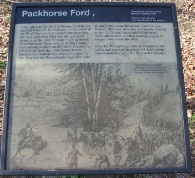
Packhorse Ford
Only 431 Pennsylvania soldiers returned to the safety and cover of Maryland soil. Lee's troops then withdrew, ending the Maryland Campaign.
Erected by Chesapeake and Ohio Canal National Park, National Park Service, U.S. Dept of the Interior.
Topics and series. This historical marker is listed in this topic list: War, US Civil. In addition, it is included in the Chesapeake and Ohio (C&O) Canal series list.
Location. 39° 25.887′ N, 77° 46.889′ W. Marker is near Sharpsburg, Maryland, in Washington County. Marker can be reached from Canal Road, on the right when traveling east. Located on the Chesapeake and Ohio Canal Towpath, to the east of lock number 38, near mile stone 72. Touch for map. Marker is in this post office area: Sharpsburg MD 21782, United States of America. Touch for directions.
Other nearby markers. At least 8 other markers are within walking distance of this marker. 118th Pennsylvania Infantry (approx. 0.2 miles away in West Virginia); Barnes' Brigade (approx. 0.2 miles away in West Virginia); Battle of Shepherdstown (approx. 0.2 miles away in West Virginia); Shepherdstown Battlefield Preservation Association (approx. ¼ mile away in West Virginia); Battle of Boteler's Ford (approx. 0.3 miles away in West Virginia); Boteler’s Ford Tablet B. F. 3 (approx. 0.3 miles away in West Virginia); Boteler’s Ford Tablet B. F. 2 (approx. 0.3 miles away in West Virginia); Boteler’s Ford Tablet B. F. 1 (approx. 0.3 miles away in West Virginia).
More about this marker. The lower half of the marker is a drawing of the 118th Pennsylvania Infantry preparing to cross the Potomac River at Packhorse Ford. From Harper's Weekly, October 11, 1862.
Credits. This page was last revised on August 4, 2020. It was originally submitted on April 9, 2008, by Craig Swain of Leesburg, Virginia. This page has been viewed 2,099 times since then and 62 times this year. Last updated on August 3, 2020, by Bradley Owen of Morgantown, West Virginia. Photos: 1, 2, 3. submitted on April 9, 2008, by Craig Swain of Leesburg, Virginia. • J. Makali Bruton was the editor who published this page.


