Near Charles Town in Jefferson County, West Virginia — The American South (Appalachia)
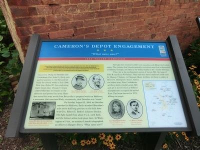
Cameron's Depot Engagement
"What news now?"
— 1864 Valley Campaign —
Inscription.
The Federal offensive in the Shenandoah Valley begun in May 1864 faltered in the summer with Confederate victories and Gen. Jubal A. Early's Washington Raid in July. Union Gen. Philip H. Sheridan took command in August, defeated Early at Winchester in September and Cedar Creek in October, burned mills and barns, and crushed the remnants of Early's force at Waynesboro on March 2, 1865. Sheridan's victories contributed to President Abraham Lincoln's reelection in November 1864 and denied Gen. Robert E. Lee's army much-needed provisions from the "Breadbasket of the Confederacy."
Union Gen. Philip H. Sheridan and Confederate Gen. Jubal A. Early jockeyed for position in the Shenandoah Valley for several weeks in July 1864. With Gen. Robert E. Lee reinforcing Early, Union Gen. Ulysses S. Grant ordered Sheridan to remain on the defensive and protect his army. Sheridan moved his army north from Berryville to prepared works at Halltown, a movement that convinced Early, erroneously, that Sheridan was “timid”.
On Sunday, August 21, 1864, as Sheridan marched to Halltown, Early attacked Sheridan’s mile-and-a half long position on the hills here with Gen Robert E. Rodes’s infantry division. The fight lasted from about 9 A.M. until dusk, and the hottest action took place here. In Washington at 3 P.M., an anxious Lincoln telegraphed an officer in Harpers Ferry "What news now?"
The fight here resulted in 260 Union casualties and 160 for the Confederates. The victories that Lincoln needed for reelection came first in September at Atlanta, Georgia, and then in the Valley, thanks to the “timid” Sheridan.
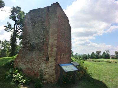
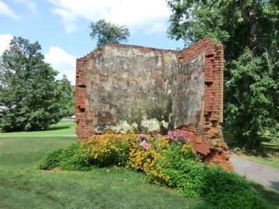
This ruin is the northwestern corner of Locust Hill, the home of John B. and Lucy W. Packett. They and their slaves sheltered inside until Lt. Henry J. Nichols, 1st Vermont Heavy Artillery, led them to safety at Henry B. Davenport’s House. Nine Confederate artillery shells struck Locust Hill and set it on fire twice as Federal sharpshooters occupied the second floor. The house burned in 1973, killing six people.
Erected by West Virginia Civil War Trails.
Topics and series. This historical marker is listed in this topic list: War, US Civil. In addition, it is included in the West Virginia Civil War Trails series list. A significant historical month for this entry is March 1941.
Location. Marker has been reported missing. It was located near 39° 17.436′ N, 77° 54.516′ W. Marker was near Charles Town, West Virginia, in Jefferson County. Marker could be reached from Sheriden Drive. The marker is behind the house on 120 Sheriden Drive. It is on the grounds of the Locust Hill Golf Course. Touch for map. Marker was at or near this postal address: 120 Sheriden Drive, Charles Town WV 25414, United States of America. Touch for directions.
Other nearby markers. At least 8 other markers are within 3 miles of this location, measured as the crow flies. Locust Hill (here, next to this marker); Richwood Hall (approx. 0.6 miles away); a different marker also named "Locust Hill" (approx. 0.8 miles away); Harewood (approx. one mile away); Cameron's Depot (approx. 1.2 miles away); Cedar Lawn (approx. 1.2 miles away); Brownfields to Greenfields (approx. 2.3 miles away); A Brief History of the Old Presbyterian Church in Charles Town (approx. 2.4 miles away). Touch for a list and map of all markers in Charles Town.
More about this marker. The brick structure is no longer standing.
Credits. This page was last revised on January 6, 2024. It was originally submitted on August 16, 2012, by Don Morfe of Baltimore, Maryland. This page has been viewed 1,250 times since then and 74 times this year. Last updated on January 4, 2024, by Carl Gordon Moore Jr. of North East, Maryland. Photos: 1, 2. submitted on August 16, 2012, by Don Morfe of Baltimore, Maryland. 3. submitted on August 26, 2012, by Don Morfe of Baltimore, Maryland. 4. submitted on November 6, 2020, by Bradley Owen of Morgantown, West Virginia. • J. Makali Bruton was the editor who published this page.


