Near Dune Acres in Porter County, Indiana — The American Midwest (Great Lakes)
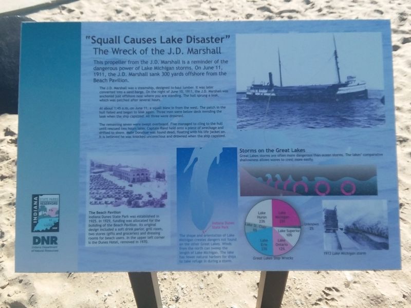
"Squall Causes Lake Disaster"
The Wreck Of The J.D. Marshall
This propeller from the J.D. Marshall is a reminder of the dangerous power of Lake Michigan storms. On June 11, 1911, the J.D. Marshall sank 300 yards offshore from the Beach Pavilion.
The J.D. Marshall was a steamship, designed to haul lumber. It was later converted into a sand barge. On the night of June 10, 1911, the J.D. Marshall was anchored just offshore near where you are standing. The hull sprung a leak, which was patched after several hours.
At about 1:45 a.m. on June 11, a squall blew in from the west. The patch in the hull failed and began to leak again. Three men were below deck mending the teak when the ship capsized, All three were drowned.
The remaining seven were swept overboard. Five managed to cling to the hull until rescued two hours later. Captain Rand held onto a piece of wreckage and drifted to shore. Mate Donahue was found dead, floating with his life jacket on. It is believed he was knocked unconscious and drowned when the ship capsized.
The Beach Pavilion
Indiana Dunes State Park was established in 1925, In 1929, funding was allocated for the building of the Beach Pavilion. Its original design included a soft drink parlor, grill room, two stores (gifts and groceries) and dressing rooms for beach users. In the upper left corner is the Dunes Hotel, removed in 1970.
The shape and orientation of Lake Michigan creates dangers not found on the other Great Lakes. Winds from length of Lake Michigan. The lake has fewer natural harbors for ships to take refuge in during a storm.
Storms on the Great Lakes
Great Lakes storms are often more dangerous than ocean storms. The lakes' comparative shallowness allows waves to crest more easily.
Erected by Indiana Department of Natural Resources.
Topics. This historical marker is listed in these topic lists: Disasters • Waterways & Vessels. A significant historical date for this entry is June 11, 1911.
Location. 41° 39.733′ N, 87° 3.767′ W. Marker is near Dune Acres, Indiana, in Porter County. Marker is on Indiana Route 25E, 0.1 miles north of Indiana Dunes State Park Drive, on the right when traveling north. Touch for map. Marker is in this post office area: Chesterton IN 46304, United States of America. Touch for directions.
Other nearby markers. At least 8 other markers are within 3 miles of this marker, measured as the crow flies. Dune Creek Watershed: What Makes It Special? (within shouting distance of this marker); Le Petit Fort (about 500 feet away, measured in a direct line); The J.D. Marshall (approx. 0.7 miles away); Dunes Hi-Way (approx. 1.3 miles away); Cowles Bog (approx. 1.4 miles away); Indiana State Police Dunes Park Post #1 (approx. 1.9 miles away); Iron Brigade (approx. 1.9 miles away); Edwin Way Teale (approx. 2.7 miles away).
Credits. This page was last revised on December 2, 2020. It was originally submitted on December 2, 2020, by Craig Doda of Napoleon, Ohio. This page has been viewed 166 times since then and 13 times this year. Photo 1. submitted on December 2, 2020, by Craig Doda of Napoleon, Ohio. • Devry Becker Jones was the editor who published this page.
