Henrico in Henrico County, Virginia — The American South (Mid-Atlantic)
Fort Brady
Richmond-Petersburg Campaign
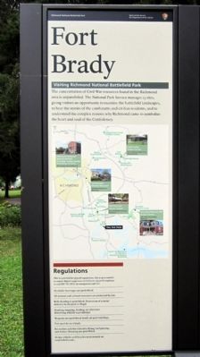
Fort Brady
Visiting Richmond National Battlefield Park
The concentration of Civil War resources found in the Richmond area is unparalleled. The National Park Service manages 13 sites, giving visitors an opportunity to examine the battlefield landscapes, to hear the stories of the combatants and civilian residents, and to understand the complex reasons why Richmond came to symbolize the heart and soul of the Confederacy.
Regulations
This is a partial list of park regulations. Site is open sunrise to sunset. Report suspicious activities to any park employee or call 804-795-5018. In emergencies call 911.
Alcoholic beverages are prohibited.
All natural and cultural resources are protected by law.
Relic hunting is prohibited. Possession of a metal detector in the park is illegal.
Hunting, trapping, feeding, or otherwise disturbing wildlife is prohibited.
Weapons are prohibited inside all park buildings.
Pets must be on a leash.
Recreation activities like kite-flying, ball-playing, and frisbee throwing are prohibited.
Motor vehicles and bicycles must remain on established roads.
(center panel)
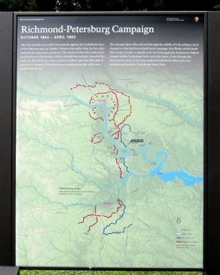
Richmond-Petersburg Campaign
October 1864 - April 1865
After the partially successful Union attacks against the Confederate lines at Fort Harrison and on Chaffin's Farm in September 1864, the two sides settled in for long-term operations. The winter of 1864-1865 witnessed a proliferation of entrenching. Soldiers in both blue and gray shoveled dirt endlessly. They built new forts to protect artillery, and mile after mile of parapets for infantry. When one army extended a line, the other army usually mirrored it.
The dynamic James River flowed through the middle of it all, adding a naval element to what had been a land-based campaign. Fort Brady, which stands intact today, became a valuable asset for Union generals. Its presence helped counter similar Confederate forts across the James. It also became the keystone in a series of riverside earthen fortifications whose presence instilled caution in the Confederate States Navy.
(right panel)
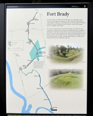
Fort Brady
In October 1864, just days after Fort Harrison was captured by Union troops, Federal engineers designed a 2˝-mile-long line of fortifications connecting Fort Harrison to Fort Brady here on the James River. Their plan called for strategically placed artillery redoubts connected by infantry trenches along the entire length.
For nearly a month the First New York Engineers, assisted by the 127th United States Colored Troops, labored to complete the work. In addition to building earthworks, they cut down trees for several hundred yards in front of the works and strengthened the defenses with sharpened tree limbs know as abatis. By November 1864, the menacing field and siege artillery moved into position, virtually ensuring a Federal presence on this side of the James River for the remainder of the war.
Erected 2011 by Richmond National Battlefield Park.
Topics. This historical marker is listed in these topic lists: Forts and Castles • War, US Civil. A significant historical month for this entry is April 1865.
Location. 37° 23.542′ N, 77° 21.645′ W. Marker is in Henrico, Virginia, in Henrico County. Marker is on Hoke Brady Road, 0.9 miles south of Kingsland Road, on the left when traveling south. Touch for map. Marker is in this post office area: Henrico VA 23231, United States of America. Touch for directions.
Other nearby markers. At least 8 other markers are within one mile of this marker, measured as the crow flies. Fort Brady Trail (a few steps from this marker); Union Defensive Lines (within shouting distance of this marker); Battle of Trent's Reach (about 400 feet away, measured in a direct line); Powder Magazine (about 400 feet away); a different marker also named Powder Magazine (about 400 feet away); Guns of Fort Brady (about 400 feet away); Guarding the James (about 500 feet away); The Tides (approx. 1.1 miles away). Touch for a list and map of all markers in Henrico.
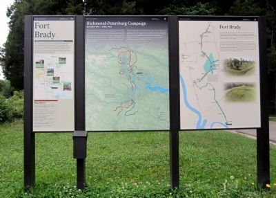
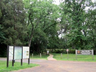
More about this marker. On the left panel is a map of Civil War sites managed by the Richmond National Battlefield Park.
On the center panel is a map of the Union and Confederate fortifications constructed during the Petersburg Siege with the caption, "Both armies extended their lines westward during the winter of 1864-65"
On the right panel is a map of the NPS Fort Harrison unit with the caption, "The national park includes pieces of both Union and Confederate defensive lines. Many of the Confederate entrenchments predate the 1864 battles. The rest were built later. Some of the fortifications no longer survive." Also shown are photos of Forts Harrison and Hoke.
Also see . . .
1. Richmond National Battlefield Park. (Submitted on June 18, 2012, by Bernard Fisher of Richmond, Virginia.)
2. Civil War Richmond. Period photographs of Fort Brady (Submitted on June 18, 2012, by Bernard Fisher of Richmond, Virginia.)
Credits. This page was last revised on September 5, 2021. It was originally submitted on June 18, 2012, by Bernard Fisher of Richmond, Virginia. This page has been viewed 970 times since then and 62 times this year. Last updated on September 3, 2021, by Bradley Owen of Morgantown, West Virginia. Photos: 1, 2, 3, 4, 5. submitted on June 18, 2012, by Bernard Fisher of Richmond, Virginia. 6. submitted on July 11, 2010, by Bernard Fisher of Richmond, Virginia.
