Lower Windsor Township in Long Level in York County, Pennsylvania — The American Northeast (Mid-Atlantic)
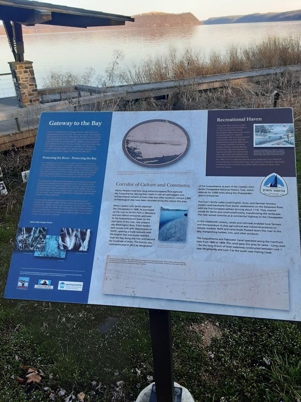
Gateway to the Bay
Protecting the River--Protecting the Bay
The Chesapeake Bay waterfront is a common ecosystem made up of numerous bodies of water including the Susquehanna River. The bay is the largest estuary in the United Staes with interrelated parts forming an environment in which rivers, streams, plants and animals depend on one another, mitigating impact the Chesapeake Bay ecosystem through pollution, land development and resource consumption. By making better choices we can help improve the bay ecosystem's health.
The Susquehenna Gateway Heritage Area incorporated the rain garden between the roadway and the boardwalk into enhancements at the Zimmerman Center to demonstrate ways to improve the ecosystem of the Susquehanna and the Chesapeake Bay. The rain garden replaces a former tall grass lawn and a variety of non-native invasive plants along the river shore, which decrease biodiversity and degrade habitats that support a healthy ecosystem.
The rain garden benefits the environment through flood control, groundwater recharge, wiidlife habitat water cooling and increased groudwater supplies. Storm water runoff from the Zimmerman Center then flows to the rain garden. The plants, soils and microorganisms in the rain garden remove many types of pollutants from the storm water before they reach the river. Creating rain gardens helps improve water quality in local streams and rivers.
Native Rain Garden Plants:
Giant Bur Reed
Fox Sedge
Lurid Shallow Sedge
In this late 19th century view, the roof and chimneys of the Dritt Mansion can be seen in the lower right, with the Susquehanna & Tidewater Canal along the waterfront and Turkey Hill in the distance across the river. The islands in the river were later submerged under Lake Clarke.
Corridor of Culture and Commerce
Native Peoples lived here long before Europeans first explored the Susquehanna, leaving their mark in rock art petroglyphs and archaeological remains at town sites and other locations. Almost 2,900 archaeological sites have been recorded along the river in this area.
When Captain John Smith explored the Chesapeake in 1608, he journeyed up
the river to Smith's Falls in Maryland
and sent Native emissaries upstream
to the Susquehannock town on the
east bank of the river, near present-
day Washington Boro. Tribal leaders
sent canoes with gifts downstream to
Smith, opening a trade network with
the English that eventually reached
from the bay along the river and beyond
for hundreds of miles. This history was
commemorated in 2012 by designation
of the Susquehanna as part of the Captain John
Smith Chesapeake National Historic Trail, which
extends for 3,000 miles along the Chesapeake
and its tributaries.
The river's fertile valley lured English, Swiss, and German farmers, hunters and merchants from earlier settlements on the Delaware River, with the first European settlers arriving about 1710. They cleared woods for farms and constructed towns, transforming the landscape. The river served colonists as a commercial highway to the Chesapeake.
In the nineteenth century, canals and railroads enabled local farmers and entrepreneurs to ship agricultural and industrial products to remote markets. Rafts and canal boats floated down the river to the bay, transporting lumber, iron, and other products.
The Susquehanna and Tidewater Canal operated along the riverfront here from 1840 to 1894. The canal gave this area its name - Long Level - for the long stretch of level waterway constructed between Lock 1 near Wrightsville and Lock 2 to the south near Fishing Creek.
Petroglyphs on Big Indian Road south of Safe Harbor Dam date to about 1000 years ago
A section from an 1870s era "Plan and Profile of the Susquehanna & Tidewater Canals” shows details of the canal's design in front of the Dritt Mansion. The Dritt house and barn, then owned by Jacob Detwiler, are shown in the center of the plan, along with a lime kiln next to what is now Long Level Road.
Recreational Haven
During the 20th century, as both industry and commercial shipping on the river declined, several hydroelectric dams were constructed to provide power to regional communities. The dams have created recreational areas that make the Susquehanna a popular destination for outdoor activities, including boating, fishing, hunting, birding, and hiking. Long Level has been a regional attraction for such activity since Lake Clarke was created with construction of Safe Harbor Dam in the 1930s. From a wilderness area to a rural landscape to an industrial environment to a recreational haven, the river has undergone significant changes over the centuries that reflect similar trends on other rivers across the nation.
[on postcard]
Safe Harbor Dam at Cabin Branch Creek, near York, Pa.
Long Level developed into a regional recreation destination after Safe Harbor Dam was built, as shown by this late 1930s postcard view of Cabin Branch Creek, located just to the south of here.
Captain John Smith
Chesapeake National Historic Trail
This historical display was developed by the Susquehanna Gateway Heritage Area with funding from the Chesapeake Bay Gateways Network and the Pennsylvania Department of Conservation & Natural Resources.
Susquehanna Gateway Pennsylvania
Chesapeake Bay Gateways Network
Pennsylvania Department of Conservation and Natural Resources
Topics. This historical marker is listed in these topic lists: Environment • Exploration • Settlements & Settlers • Waterways & Vessels. A significant historical year for this entry is 1608.
Location. 39° 58.678′ N, 76° 29.761′ W. Marker is in Long Level, Pennsylvania, in York County. It is in Lower Windsor Township. Marker is on Long Level Road (Pennsylvania Route 624), on the right when traveling north. This is on the river side of PA 624, within walking distance to north of 1706 Long Level Road, which is on the inland side of road. "Latrobe's Survey of the Susquehanna" Marker is between the subject marker and the river. Touch for map. Marker is at or near this postal address: 1706 Long Level Road, Wrightsville PA 17368, United States of America. Touch for directions.
Other nearby markers. At least 8 other markers are within walking distance of this marker. Latrobe's Survey of the Susquehanna (a few steps from this marker); Captain Thomas Cresap (within shouting distance of this marker); The Dritt Mansion: A Home at the Center of History (within shouting distance of this marker); Thomas Cresap and the Border War (within shouting distance of this marker); The John & Kathryn Zimmerman Center for Heritage (within shouting distance of this marker); Native Lands Trailhead (within shouting distance of this marker); Cresap's Fort (approx. 0.3 miles away); Susquehanna and Tidewater Canal (approx. 0.9 miles away). Touch for a list and map of all markers in Long Level.
Credits. This page was last revised on June 17, 2023. It was originally submitted on March 24, 2021, by Carl Gordon Moore Jr. of North East, Maryland. This page has been viewed 159 times since then and 9 times this year. Last updated on June 17, 2023, by Annette Fillmore of York, Pennsylvania. Photos: 1. submitted on March 24, 2021, by Carl Gordon Moore Jr. of North East, Maryland. 2. submitted on March 26, 2021, by Carl Gordon Moore Jr. of North East, Maryland. • Bill Pfingsten was the editor who published this page.

