Near Edgemoor in New Castle County, Delaware — The American Northeast (Mid-Atlantic)
Timeline of the Delaware River
1640
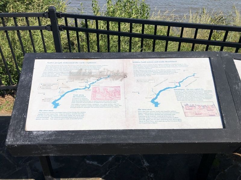
Native people welcomed the early explorers
Before the arrival of the first Europeans, this area was occupied by Lenape Indians, who depended on the forests, river valleys and waterways for their survival. When the early Dutch explorers arrived they traded for beaver skins with the Lenape. Soon after, the first known European settlement, a trading post at Fort Nassau, was established.
Later, English and Swedish settlers established communities along the river. These settlements, however, changed the lives of the Lenape people. They eventually abandoned their lands and moved northward.
Trade along the waterways
A network of streams flowing to the Delaware River permitted the Lenape to easily travel and trade with nearby tribes and with the Europeans at settlements reached by water.
The settlers brought trinkets, weapons, rum, glass bottles, and iron tools to trade with the Lenape for pelts to export to Europe. They also brought epidemic diseases that quickly killed thousands of Indians.
The river story
The streams and river provided many of the things the Lenape needed for their daily lives. Clay for pottery vessels was dug from the river banks; beach rocks were made into stone axes and arrowheads. The marshes provided food such as ducks, geese, and otter. Fish were caught in nets of braided grass.
1700
Settlers built towns and trade flourished
The English, next to arrive in the region, established landholdings in the midst of wars and political chaos. To serve this growth, the transportation and commerce routes, which had previously followed rivers and streams, were expanded overland.
As the capital and main port of the Dutch colony, New Castle became a thriving trading town. Other growing towns were Dover and Lewes. Philadelphia, however, emerged to become the largest center of commercial activity in the Delaware basin.
Philadelphia - The new capital city
Founded in 1682, Philadelphia became the legal capital of the western side of the Delaware River. Because the land office and customs office were located in Philadelphia, the commercial focus shifted away from New Castle, which had been the seat of administration and port of entry for the Delaware River settlements. As the old trading patterns changed, Philadelphia dominated the bay and its tributaries.
The river story
Soon after their arrival, Dutch and Swedish settlers began building dikes along the Delaware and Christiana Rivers. These dikes allowed the freshwater tidal marshes to be drained, creating fertile land for farming. Today, a nearly continuous series of dikes and tide gates
1776
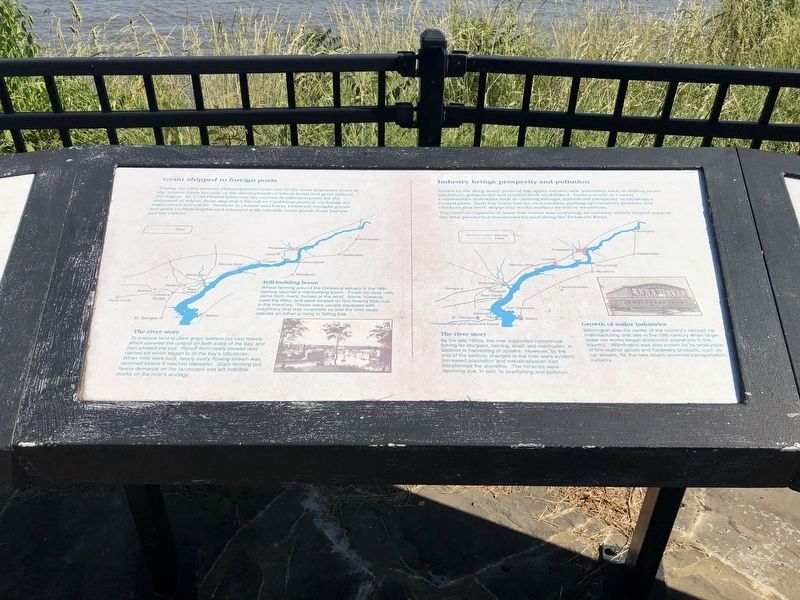
Grain shipped to foreign ports
During the 18th century, Philadelphia became one of the most important ports in the Atlantic basin because of the development of wheat farms and grain mills in the region. By 1730 Philadelphia was the central distribution point for the shipment of wheat, flour, and ship's biscuit to Caribbean ports in exchange for sugar, slaves and credit. Farmers in central and lower Delaware brought goods and grain to Philadelphia and returned with valuable trade goods from Europe and the Orient.
Mill-building boom
Wheat farming around the Delaware estuary in the 18th century spurred a mill-building boom. Power for most mills came from rivers, horses or the wind. Some, however, used the tides, and were located on fast-flowing tidal cuts in the marshes. These were usually equipped with machinery that was reversible so that the mills could operate on either a rising or falling tide.
The river story
To prepare land to plant grain, settlers cut vast forests which covered the upland on both sides of the bay, and then plowed the soil. Runoff from newly plowed land carried silt which began to fill the bay's tributaries. When mills were built, nearly every flowing stream was dammed
1850
Industry brings prosperity and pollution
Drawn to the deep water ports of the upper estuary, new industries, such as milling, heavy machinery, gunpowder and textiles were established. Farther south, in coastal communities, industries such as canning brought agricultural prosperity to Delaware's coastal plain. Each bay town had its own cannery, putting up tomatoes, peaches and chickens that were shipped to world markets by rail or steamboat.
The chief occupation of many bay towns was oystering, an industry which helped support the boat production businesses located along the Delaware River.
Growth of major industries
Wilmington was the center of the country's railroad car manufacturing until late in the 19th century when large-scale car works began production elsewhere in the country. Wilmington was also known for its production of fine leather goods and hardware products, such as car wheels, for the new steam-powered transportation industry.
The river story
By the late 1800s, the river supported commercial fishing for sturgeon, herring, shad, and menhaden, in addition to harvesting of oysters. However, by the end of the century, changes in the river were evident. Increased
1920
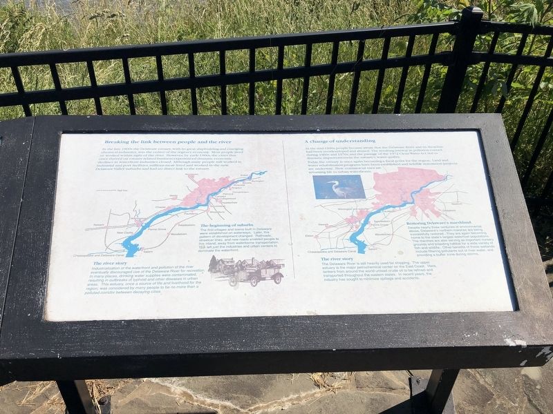
Breaking the link between people and the river
In the late 1800s the Delaware estuary, with its great shipbuilding and emerging chemical industries, was the center of the region's economy. Most people lived or worked within sight of the river. However, by early-1900s, the cities that once thrived on estuary-related business experienced dramatic economic declines as waterfront industries closed. Although many people still worked in in industrial and port facilities, millions more lived and worked in the new Delaware Valley suburbs and had no direct link to the estuary.
The beginning of the suburbs
The first villages and towns built in Delaware were established on waterways. Later, this pattern of development changed. Railroads, streetcar lines, and new roads enabled people to live inland, away from waterborne transportation. This left just the industries and urban centers dominate the waterfront.
The river story
Industrialization of the waterfront and pollution of the river eventually discouraged use of the Delaware River for recreation. In many places, drinking water supplies were contaminated, resulting in outbreaks of typhoid and other diseases in urban areas. This estuary, once a source of life and livelihood for the region, was considered by many people to be no more than a polluted corridor between decaying cities.
2000
A change of understanding
In the mid-1900s, people became aware that the Delaware River and its shoreline had been overdeveloped and abused. The resulting interest in pollution control during 1960s and 1970s, and the passage of the 1972 Clean Water Act, led to dramatic improvements in the estuary's water quality.
Today, the estuary is once again becoming a focal point for the region. Land and water rehabilitation programs have been established and wildlife restoration projects are underway. New commercial uses are returning life to urban waterfronts.
Restoring Delaware's marshland
Despite nearly three centuries of environmental abuse, Delaware's northern marshes are being successfully restored. They are again becoming home to the state's largest waterfowl populations. The marshes are also serving as important nursery grounds and breeding habitat for a wide variety of fish and wildlife. Other benefits of these wetlands including filtering pollutants out of river water, and providing a buffer zone during storms.
The river story
The Delaware River is still heavily used for shipping. The upper estuary is the major petrochemical center on the East Coast. Here, tankers from around the world unload crude oil to be refined and transported throughout the eastern states. In recent years, the industry has sought to minimize spillage and accidents.
Topics and series. This historical marker is listed in these topic lists: Industry & Commerce • Native Americans • Settlements & Settlers • Waterways & Vessels. In addition, it is included in the Delaware State Parks series list. A significant historical year for this entry is 1640.
Location. 39° 45.315′ N, 75° 29.431′ W. Marker is near Edgemoor, Delaware, in New Castle County. Marker is on Lighthouse Road, 0.7 miles north of Edgemoor Road. The marker is on the grounds of Fox Point State Park. Touch for map. Marker is at or near this postal address: 1148 Lighthouse Rd, Wilmington DE 19809, United States of America. Touch for directions.
Other nearby markers. At least 8 other markers are within 2 miles of this marker, measured as the crow flies. Natural history of the Delaware Estuary (about 500 feet away, measured in a direct line); Welcome to Fox Point State Park (approx. 0.2 miles away); Delaware: Trading with the world (approx. ¼ mile away); Memories of Fox Point (approx. ¼ mile away); Blue Rock Community Club (approx. 0.9 miles away); World War I Memorial (approx. 0.9 miles away); Mount Pleasant School (approx. 1.4 miles away); Cauffiel House and Estate (approx. 1.4 miles away).
Additional keywords. human trafficking
Credits. This page was last revised on April 11, 2023. It was originally submitted on May 31, 2021, by Devry Becker Jones of Washington, District of Columbia. This page has been viewed 434 times since then and 115 times this year. Last updated on February 7, 2022, by Carl Gordon Moore Jr. of North East, Maryland. Photos: 1, 2, 3, 4. submitted on May 31, 2021, by Devry Becker Jones of Washington, District of Columbia. • J. Makali Bruton was the editor who published this page.


