Chatsworth near Washington in Burlington County, New Jersey — The American Northeast (Mid-Atlantic)
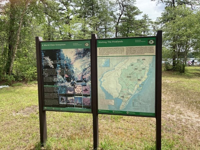
A World Class Ecosystem
— Pinelands National Preserve —
"In every season, water is the life blood of the Pinelands, sending forth nourishment to all forms of life."
From the film, My Pine Barrens Land - May 1988
At first glance, it is no wonder the early settlers called it the "Pine Barrens." Its dry sandy soil and frequent fires seem inhospitable for most plants and animals. However, the dark green forests of pitch pine, oak, Atlantic white cedar, and the abundant streams and rivers prove that it is anything but barren.
The New Jersey Pinelands is a region filled with varied bounties of nature. Over 850 species of plants and over 350 species of birds, insects, mammals, reptiles, and amphibians can be found here. Its aesthetic and scientific values are deemed priceless.
From the solemn stillness found in a cedar bog to the whispering winds blowing through forgotten company towns, the beauty of the Pinelands endures. "No other area has the same pattern of natural habitats, distribution of plant and animal populations, and unusual variety of plant and animal species." (Pinelands Comprehensive Management Plan)
National Reserve
In recognition of its unique resources, Congress, in 1978, established the Pinelands as the first National Reserve. In 1979, the State of New Jersey created the New Jersey Pinelands Commission to manage the region's development and to preserve and protect its resources. The state and federal boundaries differ slightly, but the overall goals are the same.
Because it represents one of the world's major ecosystem types, the Pinelands was designated a Biosphere Reserve by the United Nations Educational, Scientific, and Cultural Organization (UNESCO) in 1983. The Pinelands is also part of the U.S. Man and the Biosphere Program. These designations help conserve important biological areas by promoting scientific research, environmental monitoring, education, and training.
Today, the National Park Service, the State of New Jersey Division of Parks and Forestry, and the New Jersey Pinelands Commission are working to create a program to "enhance public understanding, awareness, and appreciation" of the Pinelands. The partners, with other organizations in the community, want to build on the successes of existing programs and facilities to expand interpretive and educational opportunities.
Erected by National Park Service, U.S. Department of the Interior; State of New Jersey Division of Parks & Forestry; State of New Jersey Pinelands Commission.
Topics. This historical marker is listed in this topic list: Environment. A significant historical year for this entry is 1978.
Location. 39° 44.098′ N, 74° 29.428′ W. Marker is near Washington, New Jersey, in Burlington County. It is in Chatsworth. Marker is at the intersection of Lake Oswego Road and Sooy Road, on the right when traveling east on Lake Oswego Road. Touch for map. Marker is in this post office area: Chatsworth NJ 08019, United States of America. Touch for directions.
Other nearby markers. At least 8 other markers are within 8 miles of this marker, measured as the crow flies. Speedwell (approx. 3˝ miles away); Cemetery (approx. 4.6 miles away); Chatsworth Honor Roll (approx. 6 miles away); The White Horse Inn (approx. 6.3 miles away); Central Railroad of New Jersey (approx. 6.3 miles away); Historical Horticulture (approx. 7.6 miles away); Affair at Cedar Bridge (approx. 7.7 miles away); Last Stand of the Revolution (approx. 7.7 miles away).
Credits. This page was last revised on April 7, 2024. It was originally submitted on June 22, 2021, by Thomas Anderson of Haddon Township, New Jersey. This page has been viewed 116 times since then and 22 times this year. Last updated on April 6, 2024, by Carl Gordon Moore Jr. of North East, Maryland. Photos: 1, 2. submitted on June 22, 2021, by Thomas Anderson of Haddon Township, New Jersey. • Devry Becker Jones was the editor who published this page.

