Bethesda in Montgomery County, Maryland — The American Northeast (Mid-Atlantic)
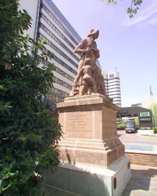
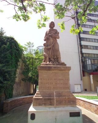
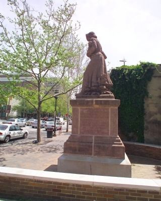
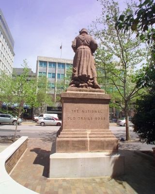
Madonna of the Trail
(East Face)
N.S.D.A.R. Memorial to the Pioneer Mothers of the Covered Wagon Days.
(North Face)
This the first military road in America beginning at Rock Creek and Potomac River, Georgetown, Maryland, leading our pioneers across this continent to the Pacific.
(South Face)
Over this highway marched the army of Major General Edward Braddock, April 14, 1755, on its way to Fort Duquesne.
(West Face)
The National Old Trails Road.
Erected 1929 by National Society Daughters of the American Revolution. (Marker Number 12.)
Topics and series. This historical marker is listed in these topic lists: Colonial Era • Roads & Vehicles • War, French and Indian. In addition, it is included in the Braddock’s Road and Maj. Gen. Edward Braddock, the Daughters of the American Revolution, and the Madonnas of the Trail series lists. A significant historical date for this entry is April 14, 1808.
Location. 38° 59.033′ N, 77° 5.652′ W. Marker is in Bethesda, Maryland, in Montgomery County. Marker is at the intersection of Wisconsin Avenue (Maryland Route 355) and Montgomery Lane, on the right when traveling south on Wisconsin Avenue. Touch for map. Marker is in this post office area: Bethesda MD 20814, United States of America. Touch for directions.
Other nearby markers. At least 8 other markers are within walking distance of this marker. In Loving Memory of Robert W. Lebling (about 300 feet away, measured in a direct line); Robert W. Lebling (about 300 feet away); Five Points, historic crossroads (about 300 feet away); Looking North up Wisconsin Avenue at Old Georgetown Road in 1940 (approx. ¼ mile away); We Drivers! (approx. ¼ mile away); Old Georgetown Road (approx. ¼ mile away); Meleney Park (approx. ¼ mile away); This Complex of Buildings and Gardens (approx. ¼ mile away). Touch for a list and map of all markers in Bethesda.
More about this marker. There are 12 identical statues, one in each state on the route of the National Road—mostly the then U.S Routes 40 and 240 when the monuments were erected—and then along the Santa Fe Trail—roughly parallelled by former U.S. Route 66—to the Pacific Ocean in California. This is the last one erected, on April 19, 1929.
This entry is dedicated to my father, Herb Fuchs. Dad was a long time resident of Bethesda. Born August 28, 1916. Died April 24, 2009. —TAF
Regarding Madonna of the Trail. North face's inscription includes "the first military road in America beginning at Rock Creek and Potomac River, Georgetown, Maryland". That Georgetown is now part of Washington DC; do not confuse with Georgetown elsewhere

Photographed By Tom Fuchs, April 28, 2009
2. Madonna of the Trail Marker (South Face)
"The Autograph of a Nation Written Across the Face of a Continent"
National Society of the Daughters of the American Revolution website entry:
Click for more information.
National Society of the Daughters of the American Revolution website entry:
Click for more information.
Related markers. Click here for a list of markers that are related to this marker. This is the next marker on the route west, in Pennsylvania.
Additional commentary.
1. Memories of Bethesda's Madonna of the Trail
As some of us recall, this memorial stood in front of the old Post Office and near the Bethesda Theatre. Madonna has been a long time landmark for Bethesda. My wife grew up a couple blocks from its location in the 1950s-70s
— Submitted July 19, 2009, by Mike Stroud of Bluffton, South Carolina.
Credits. This page was last revised on August 30, 2023. It was originally submitted on April 29, 2009, by Tom Fuchs of Greenbelt, Maryland. This page has been viewed 1,847 times since then and 42 times this year. Last updated on August 23, 2023, by Eric Marshall of The Colony, Texas. Photos: 1, 2, 3, 4. submitted on April 29, 2009, by Tom Fuchs of Greenbelt, Maryland. • Bill Pfingsten was the editor who published this page.


