Near Maumee in Lucas County, Ohio — The American Midwest (Great Lakes)
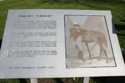
Fallen Timbers
Resentment by the Indians against white encroachment reached a peck in the 1790’s. Encouraged by the British, they began to raid settlements. Two poorly organized American military campaigns, led by General Josiah Harmar in 1790 and Governor Arthur St. Clair in 1791, were soundly defeated by the Indians. President Washington turned to Anthony Wayne to crush Indian resistance.
Wayne assembled troops at Cincinnati, then moved to Fort Greene Ville where he spent many months creating a disciplined, well-trained army. By summer 1794, he was ready to move.
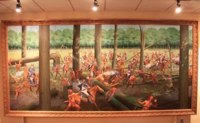
On the march to the Maumee Valley, Wayne met nearly 2,000 Indians here at a grove of trees felled by a tornado. After hard fighting, Wayne drove the Indians to the gates of nearby Fort Miamis, where he defeated them.
In the Treaty of Greene Ville, signed in 1795, the Indians surrendered their claims to most of Ohio. The treaty pacified the frontier for fifteen years and opened Ohio to peaceful settlement.
Erected 1978 by The Ohio Historical Society.
Topics and series. This historical marker is listed in these topic lists: Military • Native Americans • Notable Events • Wars, US Indian. In addition, it is included in the Former U.S. Presidents: #01 George Washington, the Indian Wars Battlefield Trails, and the National Historic Landmarks series lists. A significant historical year for this entry is 1790.
Location. 41° 32.64′ N, 83° 41.849′ W. Marker is near Maumee, Ohio, in Lucas County. Marker is on Fallen Timbers Lane, half a mile north of U.S. 24, on the left when traveling west. This marker is located about a mile southwest of the intersection of US 23 and US 24, just off of US 24 at the Fallen Timbers Lane exit, almost midway between the villages of Maumee and Waterville, Ohio. Touch for map. Marker is in this post office area: Maumee OH 43537, United States of America. Touch for directions.
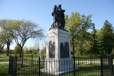
Other nearby markers. At least 8 other markers are within walking distance of this marker. Battle of Fallen Timbers (a few steps from this marker); American Indians at the Battle of Fallen Timbers (about 300 feet away, measured in a direct line); Fallen Timbers Battle Memorial (about 300 feet away); Turkey Foot Rock (about 300 feet away); Fallen Timbers Battle Monument (about 300 feet away); Maumee River Rapids (approx. 0.3 miles away); Fighting Forces (approx. 0.4 miles away); A Long March (approx. 0.4 miles away). Touch for a list and map of all markers in Maumee.
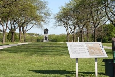
More about this marker. This monument is located in Fallen Timbers State Park, between US 24 and the Maumee River.
Regarding Fallen Timbers. The Battle of Fallen Timbers State Memorial has long been assumed to be the site of one of the most important battles in American history. Yet recently, in 1995, Dr. G. Michael Pratt, an anthropologist and faculty member at Heidelberg College, conducted an archaeological survey (using metal detectors) in a farm field about a mile to the north, north, west of the state memorial and discovered a significant number of metal battlefield artifacts, dating back to the late 1700s, and changed everyone's mind. It is now believed that the focal point of the Battle of Fallen Timbers, took place in a farm field, that is located just down the road, at the northwest corner of the intersection of US 24 and US 23/I-475 in Maumee, Ohio.
Related markers. Click here for a list of markers that are related to this marker. To better understand the relationship, study each marker in the order shown.
Also see . . .
1. The Battle of Fallen Timbers. Metroparks of the Toledo Area website entry (Submitted on June 2, 2009, by Dale K. Benington of Toledo, Ohio.)
2. Battle of Fallen Timbers. Ohio History Central website entry (Submitted on June 2, 2009, by Dale K. Benington of Toledo, Ohio.)
Credits. This page was last revised on July 10, 2022. It was originally submitted on June 2, 2009, by Dale K. Benington of Toledo, Ohio. This page has been viewed 1,980 times since then and 19 times this year. Last updated on January 29, 2021, by Craig Doda of Napoleon, Ohio. Photos: 1, 2, 3. submitted on June 2, 2009, by Dale K. Benington of Toledo, Ohio. 4. submitted on May 2, 2011, by Dale K. Benington of Toledo, Ohio. • Bill Pfingsten was the editor who published this page.


